Canals · Northern Ireland
Shannon–Erne Waterway
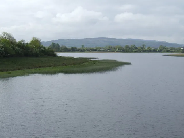
Shannon–Erne Waterway is a canal in the United Kingdom.

Wikimedia Commons contributors — see linked file page for photographer and licence licence
Plan your visit
- Typical visit
- 1 h–2 h
- Free entry
- Dog-friendly
About
Shannon–Erne Waterway is a canal in the United Kingdom. Coordinates: 54.0521°, -7.8097°. This entry is part of The Great Britain Guide, a free, ad-free, open-data tourist directory.
Photo gallery
From the Wikipedia article
The Shannon–Erne Waterway (Irish: Uiscebhealach na Sionainne is na hÉirne) is a canal linking the River Shannon in the Republic of Ireland with the River Erne in Northern Ireland. Managed by Waterways Ireland, the canal is 63 km (39 mi) in length, has sixteen locks and runs from Leitrim village in County Leitrim to Upper Lough Erne in County Fermanagh. The official opening of the Shannon–Erne Waterway took place at Corraquill Lock, just south of Teemore in the south of County Fermanagh, on 23 May 1994.
Excerpt from Wikipedia under CC BY-SA 4.0. See the source article linked in Sources below.
Background
History
The earliest known name of the Shannon–Erne Waterway was the River Gráinne (Sruth Gráinne in Irish, meaning 'the Gravelly River' or 'the Gravelly Stream'). The earliest surviving mention of the river name is in a poem composed about 1291 which gives the name as Sruth Gráinne: The Annals of Loch Cé for the year 1457 state: The Annals of Ulster for the year 1457 state: The 1609 Plantation of Ulster baronial map for the Barony of Loughtee, County Cavan, depicts the river as Graine Flumen (Latin for 'Graine River'). After the Cromwellian settlement of Ireland in the 1650s, the river was renamed as the Woodford River, after the Woodford Demesne in County Leitrim, through which the river flowed.…
Sourced from Wikipedia under CC BY-SA 4.0.
- Coordinates
- 54.0521, -7.8097
- Established
- 1870
Sources
- wikidata: Q844577 (CC0)
- wikipedia: Shannon–Erne Waterway (CC BY-SA 4.0)
- commons: Castlefore Lock on the Shannon-Erne Waterway - geograph.org.uk - 1306846.jpg (CC BY-SA 4.0)
Other places nearby
Loading nearby places…
Nearby
 📷 3
📷 3Natural landmarks · Northern Ireland
Slieve Rushen
Slieve Rushen is a natural landmark in the United Kingdom.
 📷 4
📷 4Natural landmarks · Northern Ireland
Tomregan
Tomregan in Northern Ireland, United Kingdom.
 📷 5
📷 5Natural landmarks · Northern Ireland
Cuilcagh
Cuilcagh — mountain in the United Kingdom.
 📷 5
📷 5Mountains & hills · Northern Ireland
Cuilcagh
Cuilcagh — Named summit at 666 m.
 📷 5
📷 5Mountains & hills · Northern Ireland
Cuilcagh
Cuilcagh — Named summit at 666 m.
Mountains & hills · Northern Ireland
Knockateggal
Knockateggal — mountain in northern ireland. Elevation: 333 m.
More places in this region
 📷 3
📷 3Canals · Northern Ireland
Broharris Canal
Broharris Canal is a canal in the United Kingdom.
_-_geograph.org.uk_-_5423599.jpg?width=1200) 📷 2
📷 2Canals · Northern Ireland
Coalisland Canal
Coalisland Canal — canal in County Tyrone.

Canals · Northern Ireland
Dukart's Canal
Dukart's Canal — failed coal transport system in Ireland.
 📷 5
📷 5Canals · Northern Ireland
Lagan Canal
Lagan Canal — canal between Belfast and Lough Neagh, Northern Ireland.
Frequently asked questions
- Where is Shannon–Erne Waterway?
- Shannon–Erne Waterway is in Northern Ireland, United Kingdom.
- What is Shannon–Erne Waterway?
- Shannon–Erne Waterway is a canal in the United Kingdom.
- How do I get to Shannon–Erne Waterway?
- Its coordinates are 54.0521°, -7.8097°.
- When was Shannon–Erne Waterway built?
- Built or established in 1870.
- Is Shannon–Erne Waterway free to visit?
- Yes, Shannon–Erne Waterway is free to enter.