Natural landmarks · Northern Ireland
Cuilcagh
Also known as: Binn Chuilceach
Cuilcagh — mountain in the United Kingdom.

Wikimedia Commons contributors — see linked file page for photographer and licence licence
Plan your visit
- Typical visit
- 1 h–2 h
- Free entry
- Dog-friendly
About
Cuilcagh is a named natural landmark in the United Kingdom. Wikidata describes it as: "mountain in the United Kingdom". Coordinates: 54.2000°, -7.8110°.
Photo gallery
From the Wikipedia article
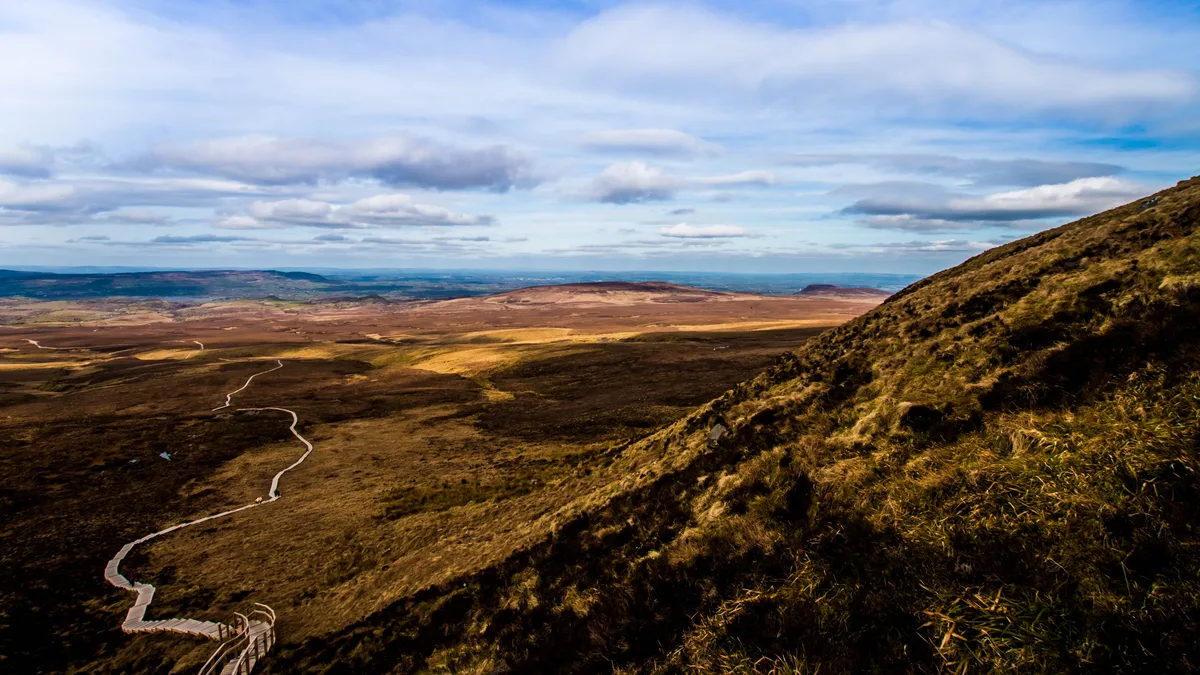
Cuilcagh (from Irish Binn Chuilceach, meaning 'chalky peak') is a mountain on the border between County Fermanagh (in Northern Ireland) and County Cavan (in the Republic of Ireland). With a height of 666 metres (2,185 ft) it is the highest point in both counties. It is also the 170th highest peak on the island of Ireland, and Ireland's only cross-border county top. Water from the southern slope flows underground until it emerges some miles away in the Shannon Pot, the traditional source of the River Shannon. The area is sometimes referred to as the Cuilcagh Mountains.
Excerpt from Wikipedia under CC BY-SA 4.0. See the source article linked in Sources below.
- Coordinates
- 54.2000, -7.8110
- Address
- County Fermanagh, Northern Ireland and County Cavan, Republic of Ireland
- Official site
- rsis.ramsar.org
Sources
- wikidata: Q3544420 (CC0)
- wikipedia: Cuilcagh (CC BY-SA 4.0)
- commons: Cuilcagh, Fermanagh - 33673331471.jpg (CC BY-SA 4.0)
Other places nearby
Loading nearby places…
Nearby
 📷 5
📷 5Mountains & hills · Northern Ireland
Cuilcagh
Cuilcagh — Named summit at 666 m.
 📷 5
📷 5Mountains & hills · Northern Ireland
Cuilcagh
Cuilcagh — Named summit at 666 m.
 📷 5
📷 5Mountains & hills · Northern Ireland
Aghatirourke
Aghatirourke — mountain in northern ireland. Elevation: 418 m.
 📷 3
📷 3Mountains & hills · Northern Ireland
Aghatirourke
Aghatirourke — mountain in northern ireland. Elevation: 395 m.
Mountains & hills · Northern Ireland
Tullynahunshin
Tullynahunshin — mountain in northern ireland. Elevation: 372 m.
 📷 4
📷 4Mountains & hills · Northern Ireland
Gortmaconnell
Gortmaconnell — mountain in northern ireland. Elevation: 336 m.
Where to eat & stay near Cuilcagh
Places to stay
 📷 5
📷 5Caravan parks · Northern Ireland
Rushin House Caravan Park
Rushin House Caravan Park — a caravan park in northern ireland.
 📷 4
📷 4Caravan parks · Northern Ireland
Riverside Farm, Marina & Caravan Park
Riverside Farm, Marina & Caravan Park — a caravan park in northern ireland.
 📷 3
📷 3Caravan parks · Northern Ireland
Lisnaskea Caravan Park
Lisnaskea Caravan Park — a caravan park in northern ireland.
 📷 5
📷 5Hotels · Northern Ireland
Lough Erne Golf Resort
Lough Erne Golf Resort — a hotel in northern ireland.
 📷 5
📷 5Campsites · Northern Ireland
Crom Campsite
Crom Campsite — a campsite in northern ireland.
More natural landmarks in this region
 Flagship📷 4
Natural landmarks · Northern Ireland
Lough Erne
Lough Erne — lake in County Fermanagh, Northern Ireland, UK.
 Flagship📷 4
Natural landmarks · Northern Ireland
Lough Neagh
Lough Neagh — large lake in Northern Ireland.
 📷 3
📷 3Natural landmarks · Northern Ireland
Ballysaggart Lough
Ballysaggart Lough — lake in the United Kingdom.
 📷 5
📷 5Natural landmarks · Northern Ireland
Belmore Mountain
Belmore Mountain — mountain in the United Kingdom.
Frequently asked questions
- Where is Cuilcagh?
- Cuilcagh is in Northern Ireland, United Kingdom.
- What is Cuilcagh?
- Cuilcagh — mountain in the United Kingdom.
- How do I get to Cuilcagh?
- Its coordinates are 54.2000°, -7.8110°.
- Is Cuilcagh free to visit?
- Yes, Cuilcagh is free to enter.