Mountains & hills · Scottish Highlands
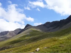
Sgurr na Banachdaich
Sgurr na Banachdaich — a hill or mountain in scotland highlands.

Martyn Ayre — CC BY-SA 2.0 via Wikimedia Commons licence
Plan your visit
- Typical visit
- 3 h–8 h
- Best time of year
- Late spring – early autumn (May–Oct)
About
A British hill or mountain, named on Ordnance Survey maps and walked by hill-baggers. Sgurr na Banachdaich is a named hill or mountain in scotland highlands, recorded in the GeoNames UK gazetteer. British landmarks of this type are typically marked on Ordnance Survey maps and recorded in the national gazetteer for cartographic and navigational reference. Coordinates and feature classification are sourced from the GeoNames open dataset.
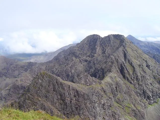
Photo gallery
Place summary
Sgurr na Banachdaich is a mountain located in the Scottish Highlands. It is part of the Black Cuillin range on the Isle of Skye, known for its rugged terrain and dramatic landscapes. The mountain offers challenging climbing routes and stunning views, appealing to experienced walkers and climbers. Visitors can expect varied weather conditions, typical of the region, and should be prepared for a strenuous ascent.
AI-generated from the structured facts on this page (operator, designation, listing, era). Not a substitute for visiting.
- Coordinates
- 57.2210, -6.2416
Sources
- manual: geonames-6696204 (CC BY 4.0)
Other places nearby
Loading nearby places…
Nearby
 📷 3
📷 3Natural landmarks · Scottish Highlands
Sgùrr na Banachdaich
Sgùrr na Banachdaich — 965m high mountain in Highland, Scotland, UK.
 📷 3
📷 3Mountains & hills · Scottish Highlands
Sgùrr na Banachdaich
Sgùrr na Banachdaich — Named summit at 965 m.
📷 5Mountains & hills · Scottish Highlands
Sgùrr na Banachdaich Central Top
Sgùrr na Banachdaich Central Top — mountain in scotland highlands. Elevation: 942 m.
 📷 5
📷 5Mountains & hills · Scottish Highlands
An Diallaid
An Diallaid — mountain in scotland highlands. Elevation: 710 m.
 📷 3
📷 3Mountains & hills · Scottish Highlands
Sgùrr a' Ghreadaidh
Sgùrr a' Ghreadaidh — Named summit at 973 m.
 📷 3
📷 3Natural landmarks · Scottish Highlands
Sgùrr a' Ghreadaidh
Sgùrr a' Ghreadaidh — 973m high mountain in Highland, Scotland, UK.
Where to eat & stay near Sgurr na Banachdaich
Places to stay
 📷 5
📷 5Hostels · Scottish Highlands
Glenbrittle Youth Hostel
Glenbrittle Youth Hostel — a hostel in scotland highlands. Brand: Hostelling Scotland.
 📷 5
📷 5Campsites · Scottish Highlands
Glenbrittle Campsite
Glenbrittle Campsite — a campsite in scotland highlands.
 📷 5
📷 5Hostels · Scottish Highlands
Sligachan Bunkhouse
Sligachan Bunkhouse — a hostel in scotland highlands.
 📷 5
📷 5Campsites · Scottish Highlands
Sligachan Campsite
Sligachan Campsite — a campsite in scotland highlands.
 📷 5
📷 5Hostels · Scottish Highlands
Skyewalker Hostel
Skyewalker Hostel — a hostel in scotland highlands.
 📷 5
📷 5Hostels · Scottish Highlands
Croft Bunkhouse
Croft Bunkhouse — a hostel in scotland highlands.
More mountains in this region
 📷 3
📷 3Mountains & hills · Scottish Highlands
A' Bhuidheanach Bheag
A' Bhuidheanach Bheag — Named summit at 936 m.
 📷 3
📷 3Mountains & hills · Scottish Highlands
A' Chailleach
A' Chailleach — Named summit at 997 m.
 📷 3
📷 3Mountains & hills · Scottish Highlands
A' Chailleach
A' Chailleach — Named summit at 930 m.
 📷 3
📷 3Mountains & hills · Scottish Highlands
A' Chaoirnich
A' Chaoirnich — Named summit at 875 m.
Frequently asked questions
- Where is Sgurr na Banachdaich?
- Sgurr na Banachdaich is in the Scottish Highlands, United Kingdom.
- What is Sgurr na Banachdaich?
- Sgurr na Banachdaich — a hill or mountain in scotland highlands.
- How do I get to Sgurr na Banachdaich?
- Its coordinates are 57.2210°, -6.2416°.