Mountains & hills · Scottish Highlands
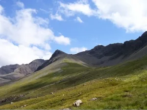
An Diallaid
An Diallaid — mountain in scotland highlands. Elevation: 710 m.

David Medcalf — CC BY-SA 2.0 via Wikimedia Commons licence
Plan your visit
- Typical visit
- 3 h–8 h
- Best time of year
- Late spring – early autumn (May–Oct)
About
An Diallaid is a mountain located in scotland highlands. Elevation: 710 m. A named British peak recorded in OpenStreetMap. Peaks are typically named on Ordnance Survey 1:50k mapping.
Photo gallery
Place summary
An Diallaid is a mountain located in the Scottish Highlands. Known for its rugged terrain and scenic views, it offers a challenging environment for hikers and outdoor enthusiasts. The area is characterised by its natural beauty, typical of the Highlands, with diverse wildlife and vegetation. Visitors can expect a range of walking trails that cater to various skill levels, providing an opportunity to experience the dramatic landscape of this remote region.
AI-generated from the structured facts on this page (operator, designation, listing, era). Not a substitute for visiting.
- Coordinates
- 57.2245, -6.2518
Sources
- osm: n2636043689 (ODbL)
Other places nearby
Loading nearby places…
Nearby
 📷 3
📷 3Mountains & hills · Scottish Highlands
Sgùrr na Banachdaich
Sgùrr na Banachdaich — Named summit at 965 m.
 📷 5
📷 5Mountains & hills · Scottish Highlands
Sgurr na Banachdaich
Sgurr na Banachdaich — a hill or mountain in scotland highlands.
 📷 3
📷 3Natural landmarks · Scottish Highlands
Sgùrr na Banachdaich
Sgùrr na Banachdaich — 965m high mountain in Highland, Scotland, UK.
📷 5Mountains & hills · Scottish Highlands
Sgùrr na Banachdaich Central Top
Sgùrr na Banachdaich Central Top — mountain in scotland highlands. Elevation: 942 m.
 📷 5
📷 5Mountains & hills · Scottish Highlands
Sgurr nan Gobhar
Sgurr nan Gobhar — a hill or mountain in scotland highlands.
📷 5Mountains & hills · Scottish Highlands
Sgùrr nan Gobhar
Sgùrr nan Gobhar — mountain in scotland highlands. Elevation: 624 m.
Where to eat & stay near An Diallaid
Places to stay
 📷 5
📷 5Hostels · Scottish Highlands
Glenbrittle Youth Hostel
Glenbrittle Youth Hostel — a hostel in scotland highlands. Brand: Hostelling Scotland.
 📷 5
📷 5Campsites · Scottish Highlands
Glenbrittle Campsite
Glenbrittle Campsite — a campsite in scotland highlands.
 📷 5
📷 5Hostels · Scottish Highlands
Sligachan Bunkhouse
Sligachan Bunkhouse — a hostel in scotland highlands.
 📷 5
📷 5Campsites · Scottish Highlands
Sligachan Campsite
Sligachan Campsite — a campsite in scotland highlands.
 📷 5
📷 5Hostels · Scottish Highlands
Skyewalker Hostel
Skyewalker Hostel — a hostel in scotland highlands.
 📷 5
📷 5Hostels · Scottish Highlands
Croft Bunkhouse
Croft Bunkhouse — a hostel in scotland highlands.
More mountains in this region
 📷 3
📷 3Mountains & hills · Scottish Highlands
A' Bhuidheanach Bheag
A' Bhuidheanach Bheag — Named summit at 936 m.
 📷 3
📷 3Mountains & hills · Scottish Highlands
A' Chailleach
A' Chailleach — Named summit at 997 m.
 📷 3
📷 3Mountains & hills · Scottish Highlands
A' Chailleach
A' Chailleach — Named summit at 930 m.
 📷 3
📷 3Mountains & hills · Scottish Highlands
A' Chaoirnich
A' Chaoirnich — Named summit at 875 m.
Frequently asked questions
- Where is An Diallaid?
- An Diallaid is in the Scottish Highlands, United Kingdom.
- What is An Diallaid?
- An Diallaid — mountain in scotland highlands. Elevation: 710 m.
- How do I get to An Diallaid?
- Its coordinates are 57.2245°, -6.2518°.