Mountains & hills · Scottish Highlands
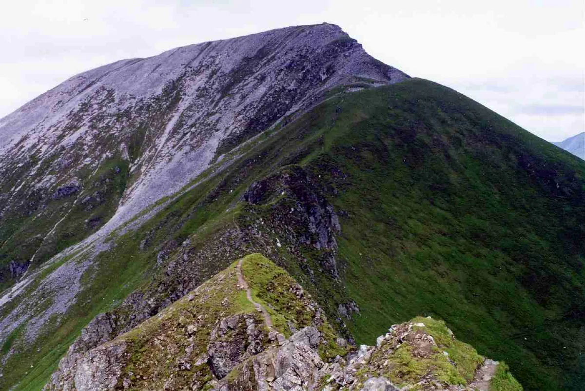
Sgurr a' Mhaim
Sgurr a' Mhaim — a hill or mountain in scotland highlands.

Doug Lee — CC BY-SA 2.0 via Wikimedia Commons licence
Plan your visit
- Typical visit
- 3 h–8 h
- Best time of year
- Late spring – early autumn (May–Oct)
About
A British hill or mountain, named on Ordnance Survey maps and walked by hill-baggers. Sgurr a' Mhaim is a named hill or mountain in scotland highlands, recorded in the GeoNames UK gazetteer. British landmarks of this type are typically marked on Ordnance Survey maps and recorded in the national gazetteer for cartographic and navigational reference. Coordinates and feature classification are sourced from the GeoNames open dataset.
Photo gallery
Place summary
Sgurr a' Mhaim is a mountain located in the Scottish Highlands. It is part of the Mamore range and is known for its rugged terrain and dramatic views. The peak is popular among hikers and climbers, offering a challenging ascent for outdoor enthusiasts. The surrounding landscape features a mix of glens and ridges, characteristic of the Highlands.
AI-generated from the structured facts on this page (operator, designation, listing, era). Not a substitute for visiting.
- Coordinates
- 56.7559, -5.0038
Sources
- manual: geonames-8593889 (CC BY 4.0)
Other places nearby
Loading nearby places…
Nearby
 📷 3
📷 3Natural landmarks · Scottish Highlands
Sgùrr a' Mhàim
Sgùrr a' Mhàim — 1099m high mountain in Highland, Scotland, UK.
 📷 3
📷 3Mountains & hills · Scottish Highlands
Sgùrr a' Mhàim
Sgùrr a' Mhàim — Named summit at 1099 m.
 📷 5
📷 5Mountains & hills · Scottish Highlands
Stob Choire a' Mhail
Stob Choire a' Mhail — a hill or mountain in scotland highlands.
 📷 3
📷 3Mountains & hills · Scottish Highlands
Sgurr a' Mhaim - Stob Choire a' Mhail
Sgurr a' Mhaim - Stob Choire a' Mhail — a mountain in scotland-highlands, United Kingdom.
 📷 5
📷 5Mountains & hills · Scottish Highlands
Sgor an Iubhair
Sgor an Iubhair — a hill or mountain in scotland highlands.
 📷 3
📷 3Mountains & hills · Scottish Highlands
Sgùrr an Iubhair
Sgùrr an Iubhair — a mountain in scotland-highlands, United Kingdom.
Where to eat & stay near Sgurr a' Mhaim
Places to stay
 📷 5
📷 5Campsites · Scottish Highlands
Wild Camp
Wild Camp — a campsite in scotland highlands.
 📷 5
📷 5Campsites · Scottish Highlands
really small camp site
really small camp site — a campsite in scotland highlands.
📷 5Campsites · Scottish Highlands
not great but fits 2 person tent and has access to small river
not great but fits 2 person tent and has access to small river — a campsite in scotland highlands.
 📷 5
📷 5Campsites · Scottish Highlands
Kinlochleven Wild Camping Area
Kinlochleven Wild Camping Area — a campsite in scotland highlands.
 📷 5
📷 5Hotels · Scottish Highlands
MacDonald Hotel
MacDonald Hotel — a hotel in scotland highlands.
📷 5Campsites · Scottish Highlands
MacDonald Hotel Campsite
MacDonald Hotel Campsite — a campsite in scotland highlands.

More mountains in this region
 📷 3
📷 3Mountains & hills · Scottish Highlands
A' Bhuidheanach Bheag
A' Bhuidheanach Bheag — Named summit at 936 m.
 📷 3
📷 3Mountains & hills · Scottish Highlands
A' Chailleach
A' Chailleach — Named summit at 997 m.
 📷 3
📷 3Mountains & hills · Scottish Highlands
A' Chailleach
A' Chailleach — Named summit at 930 m.
 📷 3
📷 3Mountains & hills · Scottish Highlands
A' Chaoirnich
A' Chaoirnich — Named summit at 875 m.
Frequently asked questions
- Where is Sgurr a' Mhaim?
- Sgurr a' Mhaim is in the Scottish Highlands, United Kingdom.
- What is Sgurr a' Mhaim?
- Sgurr a' Mhaim — a hill or mountain in scotland highlands.
- How do I get to Sgurr a' Mhaim?
- Its coordinates are 56.7559°, -5.0038°.