Mountains & hills · Scottish Lowlands
Rushy Rig
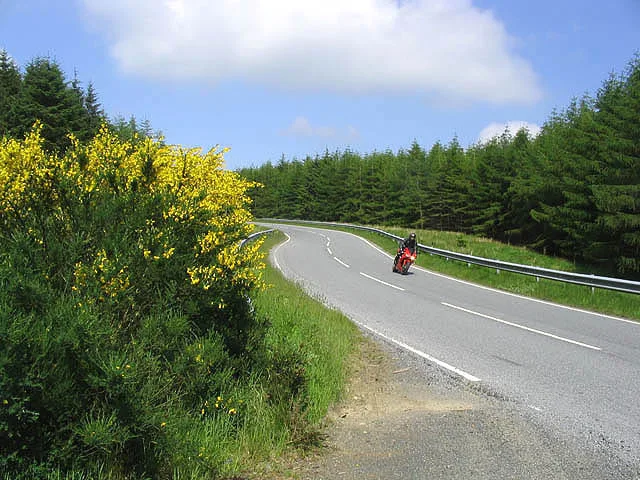
Rushy Rig — mountain in scotland lowlands. Elevation: 416 m.

David Purchase — CC BY-SA 2.0 via Wikimedia Commons licence
Plan your visit
- Typical visit
- 3 h–8 h
- Best time of year
- Late spring – early autumn (May–Oct)
About
Rushy Rig is a mountain located in scotland lowlands. Elevation: 416 m. A named British peak recorded in OpenStreetMap. Peaks are typically named on Ordnance Survey 1:50k mapping.
Photo gallery
Place summary
Rushy Rig is a mountain located in the Scottish Lowlands. It features typical terrain of the region, characterised by rolling hills and scenic views. Visitors can expect a variety of walking trails that cater to different skill levels, making it suitable for both casual walkers and more experienced hikers. The area is known for its natural beauty and wildlife.
AI-generated from the structured facts on this page (operator, designation, listing, era). Not a substitute for visiting.
- Coordinates
- 55.3179, -2.6417
Sources
- osm: n2209300884 (ODbL)
Other places nearby
Loading nearby places…
Nearby
 📷 3
📷 3Archaeological sites · Scottish Lowlands
Wauchope Forest
Wauchope Forest — forest in Scottish Borders, Scotland, UK.
 📷 5
📷 5Mountains & hills · Scottish Lowlands
Needs Law
Needs Law — mountain in scotland lowlands. Elevation: 444 m.
 📷 5
📷 5Mountains & hills · Scottish Lowlands
Coomb Edge
Coomb Edge — mountain in scotland lowlands. Elevation: 442 m.
 📷 5
📷 5Mountains & hills · Scottish Lowlands
Wigg Knowe
Wigg Knowe — mountain in scotland lowlands. Elevation: 490 m.
 📷 3
📷 3Natural landmarks · Scottish Lowlands
Piet's Nest Picnic Site
Piet's Nest Picnic Site — a other in scotland-lowlands, United Kingdom.
 📷 5
📷 5Mountains & hills · Scottish Lowlands
Dod Fell
Dod Fell — mountain in scotland lowlands. Elevation: 432 m.
Where to eat & stay near Rushy Rig
Places to stay
 📷 5
📷 5Caravan parks · Scottish Lowlands
Ravenshill Forest Park
Ravenshill Forest Park — a caravan park in scotland lowlands.
 📷 5
📷 5Campsites · Scottish Lowlands
Kielder Campsite
Kielder Campsite — a campsite in scotland lowlands.
 📷 5
📷 5Hotels · Scottish Lowlands
Mansfield House Hotel
Mansfield House Hotel — a hotel in scotland lowlands.
 📷 5
📷 5Caravan parks · Scottish Lowlands
Jedwater Caravan Park
Jedwater Caravan Park — a caravan park in scotland lowlands.
 📷 5
📷 5Campsites · Scottish Lowlands
Ruberslaw Wild Woods Camping
Ruberslaw Wild Woods Camping — a campsite in scotland lowlands.
 📷 5
📷 5Caravan parks · Scottish Lowlands
Haugh Caravan Park
Haugh Caravan Park — a caravan park in scotland lowlands.
More mountains in this region
 📷 3
📷 3Mountains & hills · Scottish Lowlands
Andrewhinney Hill
Andrewhinney Hill — Named summit at 677 m.
 📷 3
📷 3Mountains & hills · Scottish Lowlands
Arbory Hill
Arbory Hill — Named summit at 429 m.
 📷 3
📷 3Mountains & hills · Scottish Lowlands
Auchenton Hill ( East Mount Lowther)
Auchenton Hill ( East Mount Lowther) — Named summit at 631 m.
 📷 3
📷 3Mountains & hills · Scottish Lowlands
Bakestall
Bakestall — Named summit at 673.5 m.
Frequently asked questions
- Where is Rushy Rig?
- Rushy Rig is in the Scottish Lowlands, United Kingdom.
- What is Rushy Rig?
- Rushy Rig — mountain in scotland lowlands. Elevation: 416 m.
- How do I get to Rushy Rig?
- Its coordinates are 55.3179°, -2.6417°.