Mountains & hills · North East England
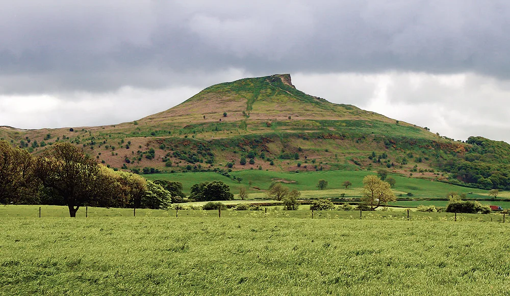
Roseberry Topping
Roseberry Topping — Named summit at 322 m.

Wikimedia Commons contributors — see linked file page for photographer and licence licence
Plan your visit
- Typical visit
- 3 h–8 h
- Best time of year
- Late spring – early autumn (May–Oct)
- Nearest railway station
- Great Ayton · 1.8 km
- Free entry
- Dog-friendly
About
Roseberry Topping is a named summit in the United Kingdom. Wikidata describes it as: "Named summit at 322 m.". Coordinates: 54.5054°, -1.1072°.
Photo gallery
Protected designations
- Site of Special Scientific Interest: Roseberry Topping SSSI
- Site of Special Scientific Interest: North York Moors SSSI
Designations sourced from Natural England open data under OGL v3.
From the Wikipedia article
Roseberry Topping is a distinctive hill in North Yorkshire, England. It is situated near Great Ayton and Newton under Roseberry. Its summit has a distinctive half-cone shape with a jagged cliff, which has led to many comparisons with the much higher Matterhorn in the Swiss-Italian Alps. It is a symbol of the area and features in the logo of the nearby Teesside International Airport. At 1,049 feet (320 m), Roseberry Topping was traditionally thought to be the highest hill on the North York Moors but there are 15 higher peaks, with the nearby Urra Moor being the highest, at 1,490 feet (450 m). Roseberry Topping offers views of Captain Cook's Monument on Easby Moor and the monument on Eston Nab, previously a beacon.
Excerpt from Wikipedia under CC BY-SA 4.0. See the source article linked in Sources below.
Background
History
The Roseberry area has been inhabited for thousands of years and the hill has long attracted attention for its distinctive shape. A Bronze Age hoard was discovered on the slopes of the hill and is now in the Sheffield City Museum. It was occupied during the Iron Age: walled enclosures and the remains of huts dating from the period are still visible in the vicinity of the hill. During this period Jet may have been mined in the area. The hill may have been held in special regard by the Vikings who settled in Cleveland during the early medieval period and gave the area many of its place names. They gave Roseberry Topping its present name: first attested in 1119 as Othenesberg, its second…
Visiting
In Joseph Reed's 1761 farce The Register-Office, the character Margery Moorpout, who hails from 'Yatton', sings the praises of 'Roseberry', which she claims to be a mile and a half high: <blockquote> Certainly God! ye knaw Roseberry? I thought ony Fule had knawn Roseberry!—It's t' biggest Hill in oll Yorkshire—It's aboun a Mile an a hofe high, an as coad as Ice at' top on't i't hettest Summer's Day—that it's. </blockquote> In 1783, Thomas Pierson, a blacksmith, watchmaker and schoolmaster from the nearby town of Stokesley, wrote an eponymous poem about the hill. Pierson's work was much admired locally and it was republished in 1847.
Sourced from Wikipedia under CC BY-SA 4.0.
- Coordinates
- 54.5054, -1.1072
- District
- Redcar and Cleveland
- Parish
- Guisborough
- Postcode
- TS9 6QS
- Parliamentary constituency
- Middlesbrough South and East Cleveland
- Nearest railway station
- Great Ayton — 1.8 km
Sources
- osm: n9886824443 (ODbL)
- wikipedia: Roseberry Topping (CC BY-SA 4.0)
- commons: Roseberry topping north side.jpg (CC BY-SA 4.0)
Other places nearby
Loading nearby places…
Nearby
 📷 5
📷 5Mountains & hills · North East England
Roseberry Topping
Roseberry Topping — Named summit at 322 m.
 📷 4
📷 4Mines & mining heritage · North East England
Roseberry Mine
Roseberry Mine in England North East, United Kingdom.
 📷 4
📷 4National parks · North East England
Newton under Roseberry
Newton under Roseberry in England North East, United Kingdom.
Mountain bike trails · North East England
Forest Enterprise Cycle Trail
Forest Enterprise Cycle Trail — a mtb trail in england north east.
Vineyards · North East England
Medieval settlement remains, post mill and field system 240m north of Pinchinthorpe Hall
human settlement in Guisborough, Redcar and Cleveland, North Yorkshire, England, UK
 📷 3
📷 3Archaeological sites · North East England
Two round cairns on Newton Moor, 850m north east of Summer Hill Farm
Two round cairns on Newton Moor, 850m north east of Summer Hill Farm — archaeological site in Guisborough, Redcar and Cleveland, England, UK.
More mountains in this region
 📷 3
📷 3Mountains & hills · North East England
Angletarn Pikes
Angletarn Pikes — Named summit at 566 m.
 📷 3
📷 3Mountains & hills · North East England
Angletarn Pikes South Top
Angletarn Pikes South Top — Named summit at 563.6 m.
 📷 3
📷 3Mountains & hills · North East England
Ard Crags
Ard Crags — Named summit at 581 m.
 📷 3
📷 3Mountains & hills · North East England
Arnison Crag
Arnison Crag — Named summit at 433 m.
Frequently asked questions
- Where is Roseberry Topping?
- Roseberry Topping is in North-East England, United Kingdom (postcode TS9 6QS), in the parish of Guisborough.
- Is Roseberry Topping a protected site?
- Yes — Roseberry Topping is part of the Roseberry Topping SSSI Site of Special Scientific Interest and the North York Moors SSSI Site of Special Scientific Interest.
- Is Roseberry Topping free to visit?
- Yes, Roseberry Topping is free to enter.
- How do I get to Roseberry Topping?
- The nearest railway station is Great Ayton, about 1.8 km away. Drivers can navigate to postcode TS9 6QS.