
Forests & woodlands · East of England
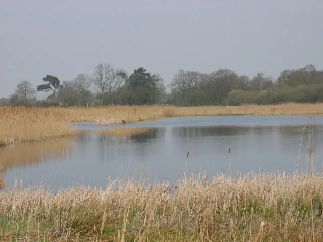
Redgrave and Lopham Fen
In or near North Lopham.
Redgrave and Lopham Fen is a forest or woodland in the United Kingdom.

Wikimedia Commons contributors — see linked file page for photographer and licence licence

Plan your visit
- Typical visit
- 1 h–3 h
- Nearest railway station
- Diss · 7.6 km
- Paid entry
- Family-friendly
- Dog-friendly
Getting there & planning your visit
To visit Redgrave and Lopham Fen, the nearest railway station is Diss, located 7.6 km away. The postcode for sat-nav is IP22 2HX, and entry to the site is free.
About
Redgrave and Lopham Fen is a named forest, woodland or nature reserve in the United Kingdom. Coordinates: 52.3769°, 1.0122°. This entry is part of The Great Britain Guide, a free, ad-free, open-data tourist directory.
Photo gallery
Official information
Redgrave and Lopham Fen is the largest valley fen in England, featuring a rich diversity of plant life across 432 acres of wetlands, grassland, and woodland. Visitors can explore various habitats and enjoy wildlife watching, including birds and unique species like the fen raft spider.
Protected designations
- Site of Special Scientific Interest: Redgrave and Lopham Fens SSSI
- National Nature Reserve: REDGRAVE & LOPHAM FEN
- Ramsar wetland: Redgrave & South Lopham Fens
Designations sourced from Natural England open data under OGL v3.
From the Wikipedia article
Redgrave and Lopham Fens is a 127 hectare biological Site of Special Scientific Interest between Thelnetham in Suffolk and Diss in Norfolk. England. It is a national nature reserve, a Ramsar internationally important wetland site, a Nature Conservation Review site, Grade I, and part of the Waveney and Little Ouse Valley Fens Special Area of Conservation. It is managed by the Suffolk Wildlife Trust. It is the largest remaining area of river valley fen in England and consists of a number of different fen types, including saw-sedge beds, as well as having areas of open water, heathland, scrub and woodland. It is also one of only three sites in the UK where the fen raft spider (Dolomedes plantarius) is known to be found.
Excerpt from Wikipedia under CC BY-SA 4.0. See the source article linked in Sources below.
Background
Visiting
The reserve is open to the public all year round. It has an Education Centre which it uses to host family activity days, school trips and adult education courses. There is a picnic area and toilet facilities. It has three dedicated nature trails of 2, 3 and 4.5 km lengths, some of which are accessible by wheelchair. . .
Sourced from Wikipedia under CC BY-SA 4.0.
- Coordinates
- 52.3769, 1.0122
- County
- Norfolk
- District
- Breckland
- Parish
- South Lopham
- Postcode
- IP22 2HX
- Parliamentary constituency
- South West Norfolk
- Phone
- 01379 687618
- Nearest railway station
- Diss — 7.6 km
- Opening
- Open all year round
- Official site
- www.suffolkwildlifetrust.org
Sources
- osm: w29406310 (ODbL)
- wikipedia: Redgrave and Lopham Fens (CC BY-SA 4.0)
- commons: Redgrave and South Lopham Fen.jpg (CC BY-SA 4.0)
Other places nearby
Redgrave and Lopham Fen
Wildlife reserves · 0.5 km
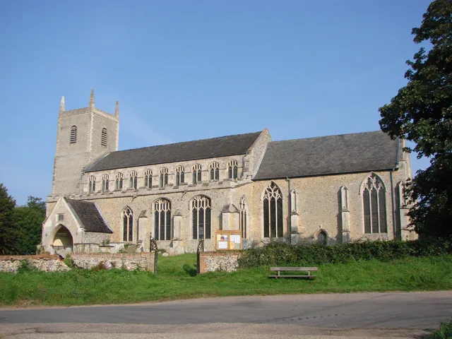
St Mary's Church, Redgrave
Historic churches · 1.6 km

Redgrave Village Sign
Public art & sculpture · 1.9 km

Redgrave
Villages · 1.9 km

South Lopham
Villages · 2.0 km

South Lopham War Memorial
Memorials & monuments · 2.0 km
War Memorial
Memorials & monuments · 2.0 km

South Lopham Village Sign#
Public art & sculpture · 2.3 km

Church of St Andrew
Historic churches · 2.4 km

Church of St John the Baptist
Historic churches · 2.7 km

Bressingham
Museums · 2.7 km

Hinderclay Fen
Forests & woodlands · 2.8 km
Nearby
📷 3Wildlife reserves · East of England
Redgrave and Lopham Fen
Redgrave and Lopham Fen — Suffolk Wildlife Trust nature reserve.
📷 3Historic churches · East of England
St Mary's Church, Redgrave
St Mary's Church, Redgrave — Grade I listed church building in Mid Suffolk, England, UK.
📷 3Public art & sculpture · East of England
Redgrave Village Sign
Redgrave Village Sign — a public art in East of England, United Kingdom.
📷 5📷 5📷 3Memorials & monuments · East of England
South Lopham War Memorial
South Lopham War Memorial — Grade II listed building-listed memorial in england-east, United Kingdom.
Where to eat & stay near Redgrave and Lopham Fen
Places to stay
 📷 5
📷 5Campsites · East of England
Hillside Farm Camping
Hillside Farm Camping — a campsite in england east.
 📷 5
📷 5B&Bs · East of England
The Red Lion
The Red Lion — a bed-and-breakfast in england east.
 📷 5
📷 5Caravan parks · East of England
Westbrook Green Farm
Westbrook Green Farm — a caravan park in england east.
 📷 5
📷 5Caravan parks · East of England
Applewood Caravan & Camping Park
Applewood Caravan & Camping Park — a caravan park in england east.
 📷 5
📷 5Caravan parks · East of England
Barn Owl Meadow
Barn Owl Meadow — a caravan park in england east.
 📷 5
📷 5Campsites · East of England
Swattesfield Campsite
Swattesfield Campsite — a campsite in england east.
Places to eat & drink
 📷 5
📷 5Restaurants · East of England
Hong Xin
Hong Xin — a restaurant in england east.
 📷 5
📷 5 📷 5
📷 5Historic pubs · East of England
Saracens Head Inn
Saracens Head Inn in England East, United Kingdom.
 📷 7
📷 7Historic pubs · East of England
The Fighting Cocks Public House
The Fighting Cocks Public House in England East, United Kingdom.
 📷 5
📷 5 📷 5
📷 5More forests in this region
 📷 5
📷 5Forests & woodlands · East of England
Adams Road Bird Sanctuary
Adams Road Bird Sanctuary is a forest or woodland in the United Kingdom.
 📷 5
📷 5Forests & woodlands · East of England
Arthur's Meadow NR
Arthur's Meadow NR is a forest or woodland in the United Kingdom.
 📷 5
📷 5Forests & woodlands · East of England
Ashwell Quarry & Quarry Springs
Ashwell Quarry & Quarry Springs is a forest or woodland in the United Kingdom.
 📷 5
📷 5Forests & woodlands · East of England
Ashwell Springs
Ashwell Springs is a forest or woodland in the United Kingdom.
Frequently asked questions
- Where is Redgrave and Lopham Fen?
- Redgrave and Lopham Fen is in Norfolk, East of England, United Kingdom (postcode IP22 2HX), in the parish of South Lopham.
- What is Redgrave and Lopham Fen?
- Redgrave and Lopham Fen is a forest or woodland in the United Kingdom.
- How do I get to Redgrave and Lopham Fen?
- The nearest railway station is Diss, about 7.6 km away. The nearest town is North Lopham. Drivers can use postcode IP22 2HX.
- Is Redgrave and Lopham Fen a protected site?
- Yes — Redgrave and Lopham Fen is part of the Redgrave and Lopham Fens SSSI Site of Special Scientific Interest and the REDGRAVE & LOPHAM FEN National Nature Reserve.
- How do I get to Redgrave and Lopham Fen?
- The nearest railway station is Diss, about 7.6 km away. Drivers can navigate to postcode IP22 2HX.