
Historic churches · South West England
Rame, Maker-with-Rame
In or near St Germans.
Rame (Cornish: Rama) is a village and former civil parish, now in the parish of Maker-with-Rame, in the Cornwall district, in the ceremonial county of Cornwall, England. It is situated on the Rame Pen

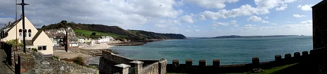
Lewis Clarke — CC BY-SA 2.0 via Wikimedia Commons licence

Plan your visit
- Typical visit
- 30 min–1 h
- Nearest railway station
- Devonport · 6.7 km
- Free entry
Getting there & planning your visit
To visit Rame, Maker-with-Rame, the nearest railway station is Devonport, located 6.7 km away. The postcode for your sat-nav is PL10 1LJ, and entry to the church is free.
About
Rame (Cornish: Rama) is a village and former civil parish, now in the parish of Maker-with-Rame, in the Cornwall district, in the ceremonial county of Cornwall, England. It is situated on the Rame Peninsula, between Rame Head and the village of Cawsand, in South East Cornwall. In 1931 the parish had a population of 501. On 1 April 1950 the parish was abolished and merged with Maker to form "Maker with Rame". Rame means the high protruding cliff, or possibly, the ram's head. Cawsand was previously in the parish of Rame but now has its own church. The parish of 'Maker-with-Rame' is formed of the hamlets Maker, which also has a church and Rame. Rame was recorded in the Domesday Book of 1086, when it was held by Ermenhald from Tavistock Abbey. There were 27 households, land for 6 ploughs, 10 acres of pasture and 30 acres of underwood. An electoral division bearing the same name also existed, but was succeeded by the Rame Peninsula division. The population as of the 2011 census was 4,763. There is another Rame near Falmouth in west Cornwall. It is believed that the west Cornwall Rame was named after the one on the Rame Peninsula. During his time in command of the Channel Fleet between 1805 and 1807 John Jervis, 1st Earl of St Vincent rented a house in Rame.
Photo gallery
See it from the streetimagery from 2022
Imagery © Mapillary contributors, CC BY-SA 4.0
Protected designations
- Site of Special Scientific Interest: Rame Head & Whitsand Bay SSSI
- Area of Outstanding Natural Beauty: Cornwall
Designations sourced from Natural England open data under OGL v3.
From the Wikipedia article
Rame (Cornish: Rama) is a village and former civil parish, now in the parish of Maker-with-Rame, in the Cornwall district, in the ceremonial county of Cornwall, England. It is situated on the Rame Peninsula, between Rame Head and the village of Cawsand, in South East Cornwall. In 1931 the parish had a population of 501. On 1 April 1950 the parish was abolished and merged with Maker to form "Maker with Rame". Rame means the high protruding cliff, or possibly, the ram's head. Cawsand was previously in the parish of Rame but now has its own church. The parish of 'Maker-with-Rame' is formed of the hamlets Maker, which also has a church and Rame. Rame was recorded in the Domesday Book of 1086, when it was held by Ermenhald from Tavistock Abbey. There were 27 households, land for 6 ploughs, 10 acres of pasture and 30 acres of underwood. An electoral division bearing the same name also existed, but was succeeded by the Rame Peninsula division. The population as of the 2011 census was 4,763. There is another Rame near Falmouth in west Cornwall. It is believed that the west Cornwall Rame was named after the one on the Rame Peninsula. During his time in command of the Channel Fleet between 1805 and 1807 John Jervis, 1st Earl of St Vincent rented a house in Rame.
Excerpt from Wikipedia under CC BY-SA 4.0. See the source article linked in Sources below.
- Coordinates
- 50.3246, -4.2133
- District
- Cornwall
- Parish
- Maker-with-Rame
- Postcode
- PL10 1LJ
- Parliamentary constituency
- South East Cornwall
- Nearest railway station
- Devonport — 6.7 km
Sources
- wikipedia: Rame, Maker-with-Rame (CC BY-SA 4.0)
Other places nearby

Church of St Germanus
Historic churches · 0.4 km

Polhawn Fort
Memorials & monuments · 0.6 km

St Andrew's Church, Cawsand
Historic churches · 1.0 km

Cawsand
Historic churches · 1.1 km
Cawsand Bay
Mountains & hills · 1.1 km

Cawsand and Rame War Memorial
Memorials & monuments · 1.2 km

Coronation of King George V
Memorials & monuments · 1.3 km

Kingsand
Historic churches · 1.3 km

The Devonport Inn
Historic pubs · 1.4 km

WW2 Chain Home Low Radar Station (remains of)
Historic houses · 1.4 km

Chapel Of St Michael
Chapels · 1.4 km

St Paul's Church, Kingsand
Historic churches · 1.4 km
Nearby
📷 4Historic churches · South West England
Church of St Germanus
Church of St Germanus — Grade I listed building-listed church in england-south-west, United Kingdom.
📷 5Memorials & monuments · South West England
Polhawn Fort
Polhawn Fort is a memorial in the United Kingdom.
📷 5Historic churches · South West England
St Andrew's Church, Cawsand
St Andrew's Church, Cawsand — a church in england-south-west, United Kingdom.
📷 5Historic churches · South West England
Cawsand
Cawsand — a church in england-south-west, United Kingdom.
📷 5Mountains & hills · South West England
Cawsand Bay
Cawsand Bay — bay on the coast of Cornwall, England.
📷 3Memorials & monuments · South West England
Cawsand and Rame War Memorial
Cawsand and Rame War Memorial — Grade II listed building-listed memorial in england-south-west, United Kingdom.
Where to eat & stay near Rame, Maker-with-Rame
Places to stay
 📷 5
📷 5 📷 5
📷 5Campsites · South West England
Whitsand Bay Holiday Park
Whitsand Bay Holiday Park — a campsite in england south west.
 📷 5
📷 5 📷 5
📷 5Hotels · South West England
Moxy Hotel
Moxy Hotel — a hotel in england south west.
 📷 5
📷 5Hostels · South West England
Plymouth Backpackers
Plymouth Backpackers — a hostel in england south west.
 📷 7
📷 7Places to eat & drink
📷 3Historic pubs · South West England
The Devonport Inn
The Devonport Inn — Historic pub — listed building or notable heritage status.
 📷 5
📷 5Cafés · South West England
The Orangery
The Orangery — a café in england south west.
 📷 7
📷 7Historic pubs · South West England
The Lugger Public House
The Lugger Public House in England South West, United Kingdom.
 📷 5
📷 5Historic pubs · South West England
The Western Public House
The Western Public House in England South West, United Kingdom.
 📷 7
📷 7 📷 7
📷 7More places in this region
 📷 5
📷 5Historic churches · South West England
Abbey Church of St Gregory the Great, Downside Abbey
Abbey Church of St Gregory the Great, Downside Abbey — church in Stratton-on-the-Fosse, Somerset, England, UK.
 📷 5
📷 5Historic churches · South West England
All Saints Church
All Saints Church — Grade I listed church in Woolley, Somerset, England, UK.
 📷 5
📷 5Historic churches · South West England
All Saints Church, Hampreston
All Saints Church, Hampreston — church in Hampreston, Dorset, England, UK.
 📷 5
📷 5Historic churches · South West England
All Saints Church, Nether Cerne
All Saints Church, Nether Cerne — church in Nether Cerne, Dorset, England, UK.
Frequently asked questions
- Where is Rame, Maker-with-Rame?
- Rame, Maker-with-Rame is in South-West England, United Kingdom (postcode PL10 1LJ), in the parish of Maker-with-Rame.
- What is Rame, Maker-with-Rame?
- Rame (Cornish: Rama) is a village and former civil parish, now in the parish of Maker-with-Rame, in the Cornwall district, in the ceremonial county of Cornwall, England. It is situated on the Rame Pen
- How do I get to Rame, Maker-with-Rame?
- The nearest railway station is Devonport, about 6.7 km away. Drivers can use postcode PL10 1LJ.
- Is Rame, Maker-with-Rame a protected site?
- Yes — Rame, Maker-with-Rame is part of the Rame Head & Whitsand Bay SSSI Site of Special Scientific Interest and the Cornwall National Landscape (AONB).
- Is Rame, Maker-with-Rame free to visit?
- Yes, Rame, Maker-with-Rame is free to enter.
- How do I get to Rame, Maker-with-Rame?
- The nearest railway station is Devonport, about 6.7 km away. Drivers can navigate to postcode PL10 1LJ.