
Archaeological sites · Mid Wales
Pumsaint
In or near Lampeter.
Pumsaint in Wales Mid, United Kingdom.

Adrian Dust — CC BY-SA 2.0 via Wikimedia Commons licence

Plan your visit
- Typical visit
- 45 min–1.5 h
- Free entry
- Dog-friendly
About
Pumsaint is a place of interest in Wales Mid, United Kingdom — drawn from open-data sources for visitor reference. See the linked Wikipedia article for the full description.
Photo gallery
See it from the streetimagery from 2019
Imagery © Mapillary contributors, CC BY-SA 4.0
From the Wikipedia article
Pumsaint is a village in Carmarthenshire, Wales, halfway between Llanwrda and Lampeter on the A482 in the valley of Afon Cothi. It forms part of the extensive estate of Dolaucothi, which is owned by the National Trust. The name is Welsh for "five saints" (pump being the word for "five"). The name is derived from the stone block at the nearby gold mines, opposite Ogofau Lodge, which has four sides, each of which has hollows probably caused by pestle impacts. It was used as an anvil for crushing gold ore in the Roman period. Excavations in the 1990s of the area adjacent to the stone showed that the stone was originally horizontal and used as an anvil for a water-powered crushing mill. There are many parallels from Spanish mines of the Roman period with similar stone anvils.
Excerpt from Wikipedia under CC BY-SA 4.0. See the source article linked in Sources below.
- Coordinates
- 52.0470, -3.9610
- District
- Carmarthenshire
- Parish
- Cynwyl Gaeo
- Postcode
- SA19 8UW
- Parliamentary constituency
- Caerfyrddin
Sources
Other places nearby
War Memorial Gates and Railings to The Village Hall, Pumpsaint
Memorials & monuments · 0.0 km

Pumpsaint
Villages · 0.1 km
Afon Twrch
Mines & mining heritage · 0.2 km

Luentinum
Archaeological sites · 0.2 km

Carreg Pumsant
Castles · 0.7 km
Carreg Pumsaint
Windmills · 0.7 km

Roman Gold Mines
Archaeological sites · 0.7 km

Careg Pumsaint
Archaeological sites · 0.7 km

Allt Ogofau
Literary houses · 0.8 km
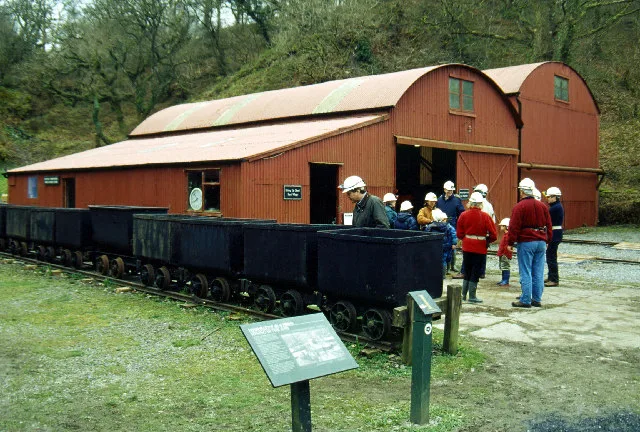
Dolaucothi Gold Mines
Hill forts · 0.8 km

Dolaucothi Estate
Historic houses · 0.9 km

Cynwyl Gaeo
Mines & mining heritage · 0.9 km
Nearby
📷 5Memorials & monuments · Mid Wales
War Memorial Gates and Railings to The Village Hall, Pumpsaint
War Memorial Gates and Railings to The Village Hall, Pumpsaint — Grade II listed building-listed memorial in wales-mid, United Kingdom.
📷 5📷 4📷 4📷 5📷 5Windmills · Mid Wales
Carreg Pumsaint
Carreg Pumsaint — a post mill in wales-mid, United Kingdom.
Where to eat & stay near Pumsaint
Places to stay
 📷 5
📷 5Caravan parks · Mid Wales
Springwater Lakes Touring Site
Springwater Lakes Touring Site — a caravan park in wales mid.
 📷 4
📷 4 📷 5
📷 5
 📷 5
📷 5Caravan parks · Mid Wales
Abermarlais Camping and Caravan
Abermarlais Camping and Caravan — a caravan park in wales south.
 📷 2
📷 2Places to eat & drink
 📷 5
📷 5 📷 3
📷 3 📷 3
📷 3 📷 4
📷 4 📷 4
📷 4 📷 3
📷 3Historic pubs · Mid Wales
The Commercial Inn
The Commercial Inn — Historic pub — listed building or notable heritage status.
More archaeological sites in this region
 📷 5
📷 5 📷 3
📷 3Archaeological sites · Mid Wales
Quaker settlement Dolgellau
Quaker settlement Dolgellau — a archaeological in wales-north, United Kingdom.
 📷 3
📷 3Archaeological sites · Mid Wales
Centenary Viewpoint
Centenary Viewpoint — a archaeological in wales-north, United Kingdom.
 📷 3
📷 3Archaeological sites · Mid Wales
Gwanas-Fawr Roman Marching Camp
Gwanas-Fawr Roman Marching Camp — a archaeological in wales-north, United Kingdom.
Frequently asked questions
- Where is Pumsaint?
- Pumsaint is in Mid Wales, United Kingdom (postcode SA19 8UW), in the parish of Cynwyl Gaeo.
- What is Pumsaint?
- Pumsaint in Wales Mid, United Kingdom.
- How do I get to Pumsaint?
- Drivers can use postcode SA19 8UW.
- Is Pumsaint free to visit?
- Yes, Pumsaint is free to enter.
- How do I get to Pumsaint?
- Drivers can navigate to postcode SA19 8UW. It sits within the Caerfyrddin parliamentary constituency.