Archaeological sites · Mid Wales
Luentinum
Also known as: Caer Rufeinig Pumsaint
In or near Lampeter.
Luentinum in Wales Mid, United Kingdom.

Dylan Moore — CC BY-SA 2.0 via Wikimedia Commons licence
Plan your visit
- Typical visit
- 45 min–1.5 h
- Free entry
- Dog-friendly
About
Luentinum is a place of interest in Wales Mid, United Kingdom — drawn from open-data sources for visitor reference. See the linked Wikipedia article for the full description.
Photo gallery
From the Wikipedia article
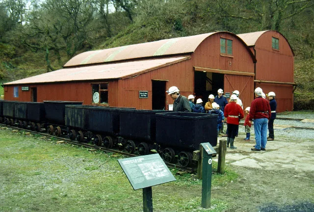
Luentinum or Loventium refers to the Roman fort at Pumsaint, Carmarthenshire. The 1.9 hectares (4.7 acres) site lies either side of the A482 in Pumsaint and was in use from the mid 70s AD to around 120 AD. It may have had particular functions associated with the adjacent Dolaucothi Gold Mines. It formed part of a network of at least 30 forts across Wales, such as Llandovery, Bremia/Llanio near Llanddewi Brefi, and the fort at Llandeilo. The Roman road Sarn Helen, which runs past the Llanio and Llandovery forts was nearby. The name Luentinum is mentioned in Ptolemy's, 2nd century AD 'Geography', and is thought to relate to washing in reference to the Pumsaint gold mines. The fort appears to have been founded as a square 5½ acre (2.25 hectare) Roman auxiliary fort controlling the adjoining gold mines, around AD 75 when Frontinus was governor of Roman Britain and active in subduing the Silures of Roman Wales. The fort had an earthen rampart and double ditch. The date of first construction was determined from a Samian ware inkwell with stamp found in the early 1970s where the river bank had cut into the fort. On the east bank of the River Cothi, a few hundred yards south of Pumsaint village, was discovered a small double-roomed building with hypocaust and plain tessellated floors. It was probably the military bath-house. The internal buildings of the fort underwent a number of rebuildings until the fort was abandoned around 140. The surrounding civilian vicus then took over the area and, no doubt, also the mines. The fort is situated about halfway between similar forts at Llandovery to the east and Bremia or Llanio to the west, with Llandeilo to the south. The fort was at the meeting point of several Roman roads in mid Wales. These were the Ffordd Fleming which ran from Loventium to Menapia (St David's), the more southerly Via Julia which also came from St David's and met the Sarn Helen near Loventium, and the Hen Fford (old road) which came from Maridunum…
Excerpt from Wikipedia under CC BY-SA 4.0. See the source article linked in Sources below.
- Coordinates
- 52.0452, -3.9616
- District
- Carmarthenshire
- Parish
- Cynwyl Gaeo
- Postcode
- SA19 8UW
- Parliamentary constituency
- Caerfyrddin
Sources
Other places nearby

Afon Twrch
Mines & mining heritage · 0.1 km
Pumsaint
Archaeological sites · 0.2 km
War Memorial Gates and Railings to The Village Hall, Pumpsaint
Memorials & monuments · 0.2 km

Pumpsaint
Villages · 0.3 km

Roman Gold Mines
Archaeological sites · 0.7 km

Carreg Pumsant
Castles · 0.7 km

Allt Ogofau
Literary houses · 0.7 km
Carreg Pumsaint
Windmills · 0.8 km

Careg Pumsaint
Archaeological sites · 0.8 km
Dolaucothi Gold Mines
Hill forts · 0.8 km

Dolaucothi Estate
Historic houses · 1.0 km

Cynwyl Gaeo
Mines & mining heritage · 1.1 km
Nearby
📷 4📷 4📷 5Memorials & monuments · Mid Wales
War Memorial Gates and Railings to The Village Hall, Pumpsaint
War Memorial Gates and Railings to The Village Hall, Pumpsaint — Grade II listed building-listed memorial in wales-mid, United Kingdom.
📷 5📷 3Archaeological sites · Mid Wales
Roman Gold Mines
Roman Gold Mines — a archaeological in wales-mid, United Kingdom.
📷 5Where to eat & stay near Luentinum
Places to stay
 📷 5
📷 5Caravan parks · Mid Wales
Springwater Lakes Touring Site
Springwater Lakes Touring Site — a caravan park in wales mid.
 📷 4
📷 4 📷 5
📷 5
 📷 5
📷 5Caravan parks · Mid Wales
Abermarlais Camping and Caravan
Abermarlais Camping and Caravan — a caravan park in wales south.
 📷 2
📷 2Places to eat & drink
 📷 5
📷 5 📷 3
📷 3 📷 3
📷 3 📷 4
📷 4 📷 4
📷 4 📷 3
📷 3Historic pubs · Mid Wales
The Commercial Inn
The Commercial Inn — Historic pub — listed building or notable heritage status.
More archaeological sites in this region
 📷 5
📷 5 📷 3
📷 3Archaeological sites · Mid Wales
Quaker settlement Dolgellau
Quaker settlement Dolgellau — a archaeological in wales-north, United Kingdom.
 📷 3
📷 3Archaeological sites · Mid Wales
Centenary Viewpoint
Centenary Viewpoint — a archaeological in wales-north, United Kingdom.
 📷 3
📷 3Archaeological sites · Mid Wales
Gwanas-Fawr Roman Marching Camp
Gwanas-Fawr Roman Marching Camp — a archaeological in wales-north, United Kingdom.
Frequently asked questions
- Where is Luentinum?
- Luentinum is in Mid Wales, United Kingdom (postcode SA19 8UW), in the parish of Cynwyl Gaeo.
- What is Luentinum?
- Luentinum in Wales Mid, United Kingdom.
- How do I get to Luentinum?
- Drivers can use postcode SA19 8UW.
- Is Luentinum free to visit?
- Yes, Luentinum is free to enter.
- How do I get to Luentinum?
- Drivers can navigate to postcode SA19 8UW. It sits within the Caerfyrddin parliamentary constituency.