Gardens · South Wales
Powis Almshouses
In or near Aust.
Powis Almshouses — a garden in wales-south, United Kingdom.

Neil Owen — CC BY-SA 2.0 via Wikimedia Commons licence
Plan your visit
- Typical visit
- 1 h–2.5 h
- Best time of year
- Spring & summer (Apr–Sep)
- Nearest railway station
- Chepstow · 0.4 km
- Dog-friendly
Getting there & planning your visit
To visit Powis Almshouses, you can take a train to Chepstow station, which is 0.4 km away. The postcode for navigation is NP16 5EZ. Entry is free.
About
Powis Almshouses is a garden of interest in wales-south, United Kingdom — drawn from open-data sources for visitor reference. See the linked Wikipedia article for the full description.
Photo gallery
See it from the streetimagery from 2024
Imagery © Mapillary contributors, CC BY-SA 4.0
Heritage listing
http://cadwpublic-api.azurewebsites.net/reports/listedbuilding/FullReport?lang=en&id=2524
From Cadw under OGL v3.
Official information
Powis Almshouses are historic almshouses located in Chepstow, offering a glimpse into the architectural and social history of the area. Visitors can explore the unique design and learn about the lives of the residents who once lived there.
Protected designations
- Site of Special Scientific Interest: River Wye SSSI
- Site of Special Scientific Interest: Severn Estuary SSSI
- Area of Outstanding Natural Beauty: Wye Valley
- Ramsar wetland: Severn Estuary
Designations sourced from Natural England open data under OGL v3.
From the Wikipedia article
The Powis Almshouses are a block of almshouses in Chepstow, Monmouthshire, Wales, at the junction of Church Street and Bridge Street (formerly St Anne's Street). The building dates from about 1721, and was constructed as a result of a bequest from Thomas Powis, a vintner who was probably born in the town. The almshouse is a Grade II* listed building.
Excerpt from Wikipedia under CC BY-SA 4.0. See the source article linked in Sources below.
Background
History
Thomas Powis was probably born in Chepstow in or about 1675, the son of Grevill Powis who may have been attached to the garrison at Chepstow Castle. Nothing is known of Thomas Powis' later life other than that, in 1716, he was a vintner in Enfield, Middlesex, and in his will gave £1,800 to establish an almshouse in Chepstow for twelve poor men and women. He died in 1716, but because of legal ambiguities over the interpretation of the will it was not settled until 1718. The land for building the almshouses was acquired by its trustees in 1721 from the Duke of Montagu, and included the remains of a mediaeval hospital and cellar. The almshouses were built soon after then; although a plaque…
Description
The building is described by architectural historian John Newman as "a delightfully artless and unspoilt ensemble... built of roughly squared local limestone." It forms an L shape, with one arm of eight bays and the other of five bays. Three doorways give access to the accommodation. Information about the bequest is set out on a plaque positioned above the doorway in the shorter range, beneath a sundial. The Almshouses were given Grade II* listed building status on 24 March 1975.
Sourced from Wikipedia under CC BY-SA 4.0.
- Coordinates
- 51.6431, -2.6743
- District
- Monmouthshire
- Parish
- Chepstow
- Postcode
- NP16 5EZ
- Parliamentary constituency
- Monmouthshire
- Nearest railway station
- Chepstow — 0.4 km
- Official site
- cadw.gov.wales
Sources
- wikidata: Q15268345 (CC0)
- wikipedia: Powis Almshouses (CC BY-SA 4.0)
Other places nearby

Castle Terrace, Chepstow
Gardens · 0.1 km

Electric Picture Hall
Theatres · 0.1 km

Mint & Mustard
Restaurants · 0.1 km

Beaufort Hotel
Historic houses · 0.1 km

Beaufort Hotel
Historic pubs · 0.1 km

Raglan Lodge
Gardens · 0.1 km
14 Beaufort Square
Gardens · 0.1 km
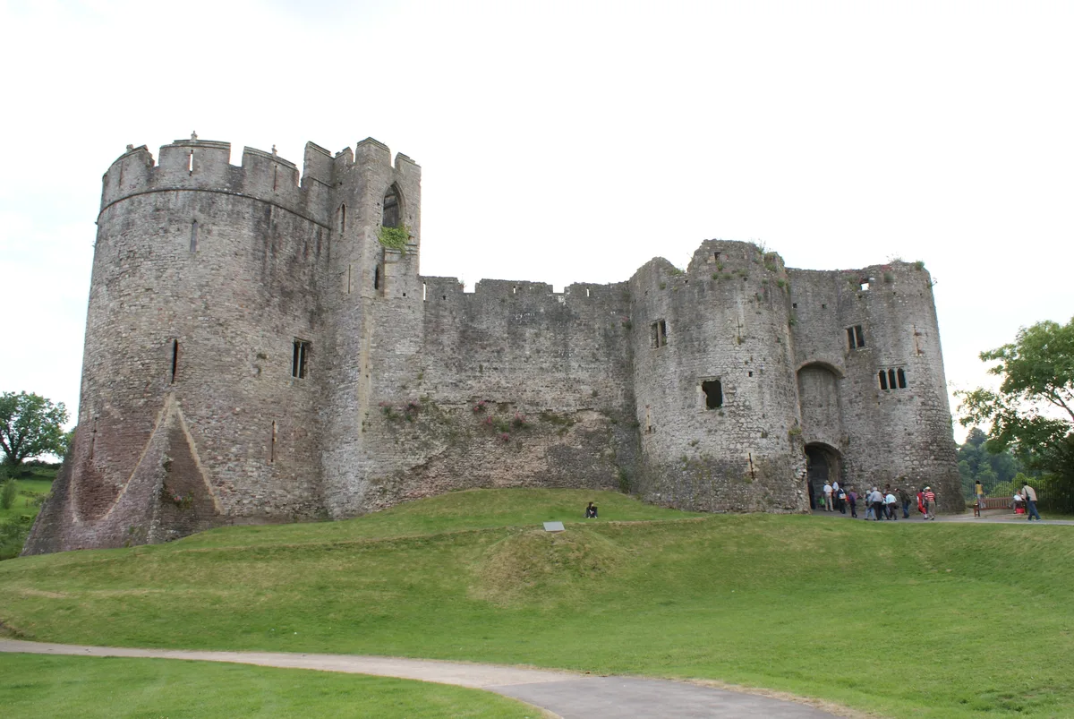
Chepstow Castle
Castles · 0.1 km

Chepstow
Hill forts · 0.1 km

Chepstow War Memorial
Memorials & monuments · 0.1 km
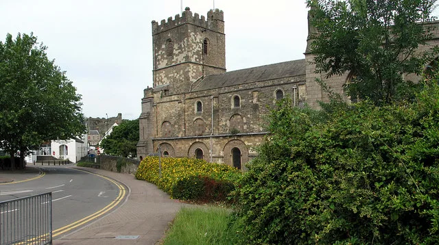
St Mary's Church
Historic churches · 0.2 km

Chepstow Port Wall
Memorials & monuments · 0.2 km
Nearby
📷 4Gardens · South Wales
Castle Terrace, Chepstow
Castle Terrace, Chepstow — a garden in wales-south, United Kingdom.
📷 3Theatres · South Wales
Electric Picture Hall
Electric Picture Hall in Wales South, United Kingdom.
📷 5Restaurants · South Wales
Mint & Mustard
Mint & Mustard — a restaurant in wales south.
📷 4Historic houses · South Wales
Beaufort Hotel
Beaufort Hotel — a Grade II*-listed historic house in wales-south, United Kingdom.
📷 7📷 4Gardens · South Wales
Raglan Lodge
Raglan Lodge — a garden in wales-south, United Kingdom.
Where to eat & stay near Powis Almshouses
Places to stay
 📷 5
📷 5 📷 5
📷 5Hotels · South Wales
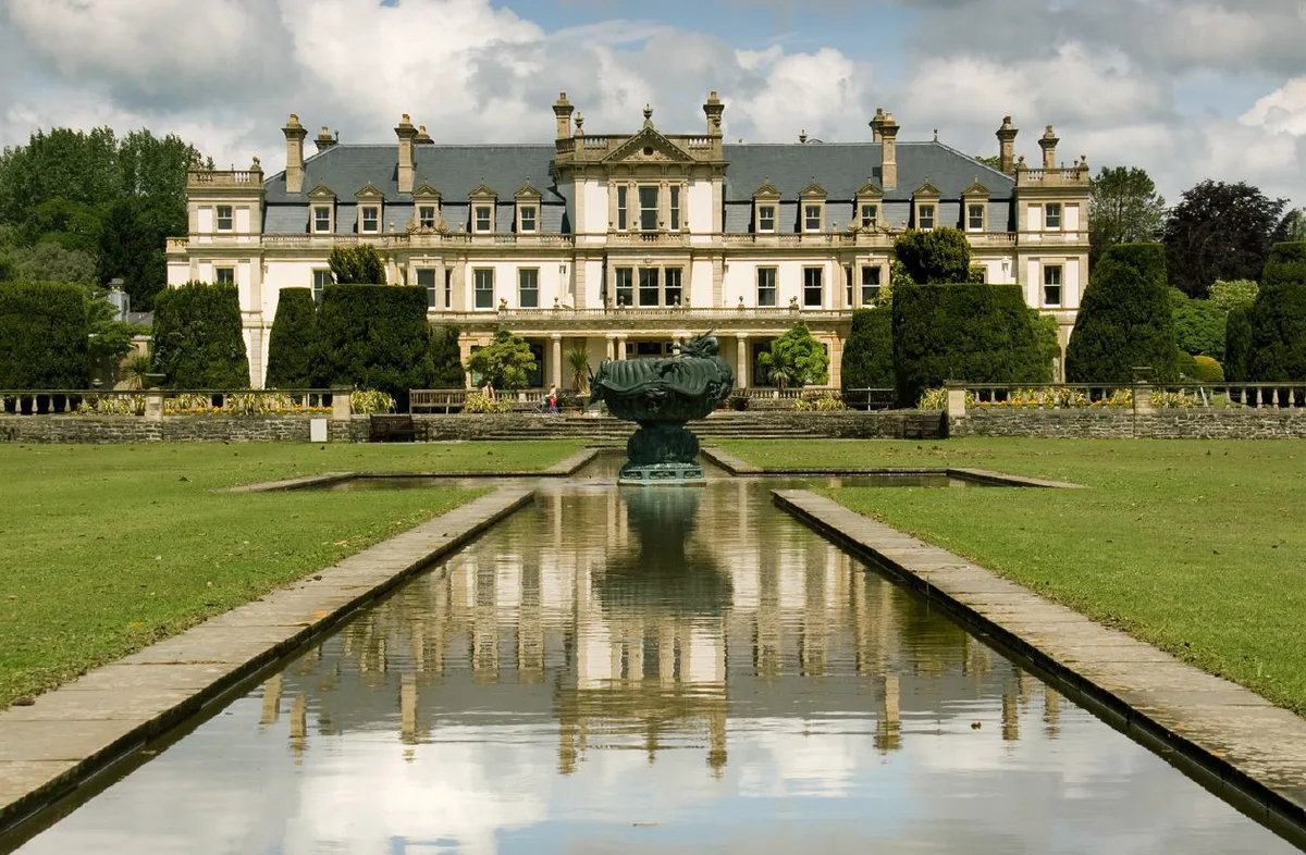
St Pierre Country Club
St Pierre Country Club — a hotel in wales south.
 📷 5
📷 5 📷 7
📷 7 📷 5
📷 5Campsites · South Wales
Beeches Farm Campsite
Beeches Farm Campsite — a campsite in wales south.
 📷 7
📷 7B&Bs · South Wales
Tintern Old Rectory B&B
Tintern Old Rectory B&B — a bed-and-breakfast in wales south.
Places to eat & drink
📷 5Restaurants · South Wales
Mint & Mustard
Mint & Mustard — a restaurant in wales south.
📷 7 📷 6
📷 6 📷 7
📷 7Historic pubs · South West England
The Boar's Head
The Boar's Head in Wales South, United Kingdom.
 📷 5
📷 5Cafés · South West England
Swan House
Swan House — a café in england west midlands.
 📷 5
📷 5Restaurants · South West England
Roobroo
Roobroo — a restaurant in england west midlands.
More gardens in this region
 📷 3
📷 3Gardens · South Wales
Clyne Gardens
Clyne Gardens — botanical garden in Swansea, Wales.
 📷 3
📷 3Gardens · South Wales
Colby Woodland Garden
Colby Woodland Garden — garden in Pembrokeshire, Wales, UK.
 📷 3
📷 3Gardens · South Wales
Cresselly House
Cresselly House — country house in Pembrokeshire, UK.
 📷 3
📷 3Gardens · South Wales
Dyffryn Gardens
Dyffryn Gardens — botanical gardens in Wales.
Frequently asked questions
- Where is Powis Almshouses?
- Powis Almshouses is in South Wales, United Kingdom (postcode NP16 5EZ), in the parish of Chepstow.
- What is Powis Almshouses?
- Powis Almshouses — a garden in wales-south, United Kingdom.
- How do I get to Powis Almshouses?
- The nearest railway station is Chepstow, about 0.4 km away. Drivers can use postcode NP16 5EZ.
- Is Powis Almshouses a listed building?
- Powis Almshouses is officially recognised as II* listed.
- Is Powis Almshouses a protected site?
- Yes — Powis Almshouses is part of the River Wye SSSI Site of Special Scientific Interest and the Severn Estuary SSSI Site of Special Scientific Interest.
- How do I get to Powis Almshouses?
- The nearest railway station is Chepstow, about 0.4 km away. Drivers can navigate to postcode NP16 5EZ.