Historic bridges · North Wales
Pont Cysyllte
In or near Ruabon.
Pont Cysyllte — scheduled monument-listed bridge in wales-north, United Kingdom.

Keith Evans — CC BY-SA 2.0 via Wikimedia Commons licence
Plan your visit
- Typical visit
- 15 min–30 min
- Nearest railway station
- Ruabon · 3.7 km
- Free entry
- Dog-friendly
Getting there & planning your visit
To visit Pont Cysyllte, the nearest railway station is Ruabon, located 3.7 km away. Entry to the bridge is free, and the postcode for navigation is LL20 7YS.
About
Pont Cysyllte is a scheduled monument-listed bridge in wales-north, United Kingdom, registered on the Cadw register of listed buildings (Wales) (entry 1602). Listed status protects buildings and structures of special architectural or historic interest. See the linked Wikipedia article for further details.
Photo gallery
Heritage listing
Pont Cysyllte, also known as Cysylltau Bridge or Bont Bridge, is a 17th-century road bridge crossing the River Dee near the village of Trevor, Wrexham County Borough, Wales. It lies 200 m west of Thomas Telford's Pontcysyllte Aqueduct and, carrying the B5434 road, is the main connection between Trevor and nearby Froncysyllte. The sandstone bridge is dated '1697', though it was substantially rebuilt during the 18th century, and only the south arch and part of the south pier are original. It became a Grade I listed structure in 1963 and is also a scheduled monument. The bridge comprises three arches, with full-height triangular cutwaters at up- and down-stream ends of both piers, each topped by a pedestrian refuge.
From Cadw under OGL v3.
Protected designations
- Site of Special Scientific Interest: River Dee (England) SSSI
Designations sourced from Natural England open data under OGL v3.
From the Wikipedia article
Pont Cysyllte, also known as Cysylltau Bridge or Bont Bridge, is a 17th-century road bridge crossing the River Dee near the village of Trevor, Wrexham County Borough, Wales. It lies 200 m west of Thomas Telford's Pontcysyllte Aqueduct and, carrying the B5434 road, is the main connection between Trevor and nearby Froncysyllte. The sandstone bridge is dated '1697', though it was substantially rebuilt during the 18th century, and only the south arch and part of the south pier are original. It became a Grade I listed structure in 1963 and is also a scheduled monument. The bridge comprises three arches, with full-height triangular cutwaters at up- and down-stream ends of both piers, each topped by a pedestrian refuge. The older, south arch has a span of 10.7 metres (35 ft) and the two newer arches have spans of 14.0 metres (46 ft) and 14.2 metres (47 ft). The bridge is frequently damaged by motor vehicles being, at its narrowest, only 2.0 m (6 ft 6 in) wide. Vehicles are required to give way to any oncoming vehicle already on the bridge.
Excerpt from Wikipedia under CC BY-SA 4.0. See the source article linked in Sources below.
- Coordinates
- 52.9707, -3.0913
- District
- Wrexham
- Parish
- Llangollen Rural
- Postcode
- LL20 7YS
- Parliamentary constituency
- Clwyd East
- Established
- 1697
- Nearest railway station
- Ruabon — 3.7 km
Sources
- wikidata: Q17744064 (CC0)
- wikipedia: Pont Cysyllte (CC BY-SA 4.0)
Other places nearby

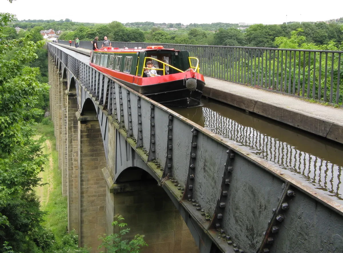
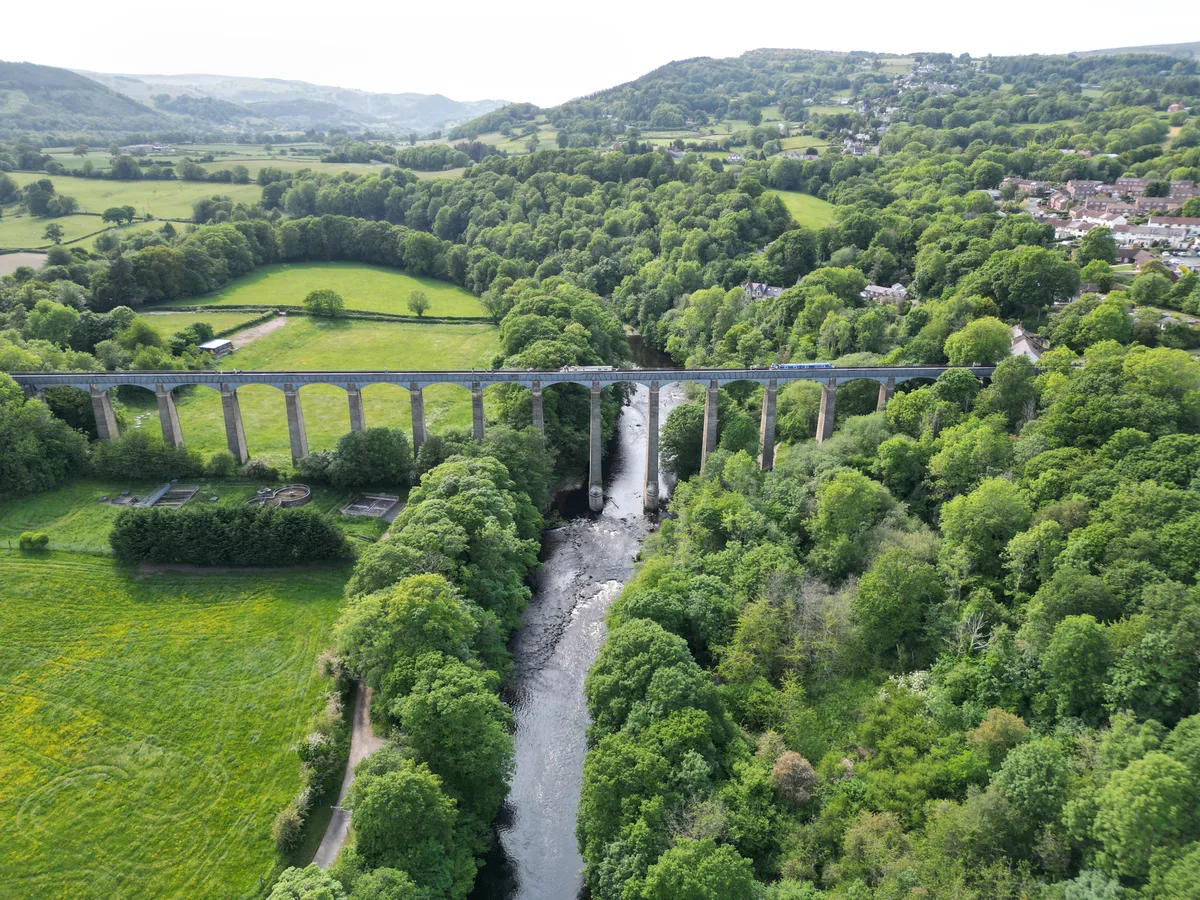
Pontcysyllte Aqueduct
Historic bridges · 0.2 km
Pontcysyllte Aqueduct
UNESCO World Heritage · 0.2 km

Bridge No 31
Historic bridges · 0.3 km
Pontcysyllte Aqueduct and Canal
UNESCO World Heritage · 0.3 km

Chapel Tearoom
Cafés · 0.4 km

Bridge next to Telford Inn
Historic bridges · 0.5 km

Trevor
Villages · 0.5 km

Chirk Castle Limestone Company/Canada Bill
Public art & sculpture · 0.7 km

Bridge No. 34 over Llangollen canal near Plas-yn-pentre
Historic bridges · 0.9 km

Cefn Bank
Viewpoints · 1.0 km

Trevor Church
Historic churches · 1.0 km

Bridge No. 35 over Llangollen canal near Plas-yn-pentre
Historic bridges · 1.2 km
Nearby
📷 5Historic bridges · North Wales
Pontcysyllte Aqueduct
Pontcysyllte Aqueduct is a historic bridge in the United Kingdom.
📷 5UNESCO World Heritage · North Wales
Pontcysyllte Aqueduct
Pontcysyllte Aqueduct — navigable aqueduct in Wales.
📷 5Historic bridges · North Wales
Bridge No 31
Bridge No 31 — Grade II listed building-listed bridge in wales-north, United Kingdom.
📷 3UNESCO World Heritage · North Wales
Pontcysyllte Aqueduct and Canal
Pontcysyllte Aqueduct and Canal — World Heritage site in Weston Rhyn, Shropshire, England, UK.
📷 5Cafés · North Wales
Chapel Tearoom
Chapel Tearoom — a café in wales north.
📷 5Historic bridges · North Wales
Bridge next to Telford Inn
Bridge next to Telford Inn — Grade II listed building-listed bridge in wales-north, United Kingdom.
Where to eat & stay near Pont Cysyllte
Places to stay
 📷 5
📷 5 📷 5
📷 5 📷 5
📷 5 📷 5
📷 5 📷 5
📷 5 📷 5
📷 5Places to eat & drink
📷 5Cafés · North Wales
Chapel Tearoom
Chapel Tearoom — a café in wales north.
 📷 5
📷 5Historic pubs · North Wales
Bridge End Inn
Bridge End Inn in Wales North, United Kingdom.
 📷 7
📷 7 📷 5
📷 5 📷 5
📷 5 📷 5
📷 5More bridges in this region
%3B_June_2023.jpg?width=1200) 📷 5
📷 5Historic bridges · North Wales
Britannia Bridge
Britannia Bridge is a historic bridge in the United Kingdom.
 📷 3
📷 3Historic bridges · North Wales
Cegin Viaduct
Cegin Viaduct is a historic bridge in the United Kingdom.
 📷 3
📷 3Historic bridges · North Wales
Chirk Aqueduct
Chirk Aqueduct is a historic bridge in the United Kingdom.
.jpg?width=1200) 📷 3
📷 3Historic bridges · North Wales
Chirk Viaduct
Chirk Viaduct is a historic bridge in the United Kingdom.
Frequently asked questions
- Where is Pont Cysyllte?
- Pont Cysyllte is in North Wales, United Kingdom (postcode LL20 7YS), in the parish of Llangollen Rural.
- What is Pont Cysyllte?
- Pont Cysyllte — scheduled monument-listed bridge in wales-north, United Kingdom.
- How do I get to Pont Cysyllte?
- The nearest railway station is Ruabon, about 3.7 km away. Drivers can use postcode LL20 7YS.
- When was Pont Cysyllte built?
- Built or established in 1697.
- Is Pont Cysyllte a listed building?
- Pont Cysyllte is officially recognised as scheduled monument listed.
- Is Pont Cysyllte a protected site?
- Yes — Pont Cysyllte is part of the River Dee (England) SSSI Site of Special Scientific Interest.
- Is Pont Cysyllte free to visit?
- Yes, Pont Cysyllte is free to enter.
- How do I get to Pont Cysyllte?
- The nearest railway station is Ruabon, about 3.7 km away. Drivers can navigate to postcode LL20 7YS.