Harbours & ports · Mid Wales
Pentrecwrt
In or near Llandysul.
Pentrecwrt in Wales Mid, United Kingdom.

Adrian Dust — CC BY-SA 2.0 via Wikimedia Commons licence
_-_geograph.org.uk_-_6322564.jpg)
Plan your visit
- Typical visit
- 45 min–1.5 h
- Nearest railway station
- Henllan High Level · 3.8 km
- Family-friendly
- Dog-friendly
About
Pentrecwrt is a place of interest in Wales Mid, United Kingdom — drawn from open-data sources for visitor reference. See the linked Wikipedia article for the full description.
Photo gallery
From the Wikipedia article
Pentrecwrt (or Pentrecourt) is a village in north Carmarthenshire, Wales on the A486 road halfway between Carmarthen and New Quay.
Excerpt from Wikipedia under CC BY-SA 4.0. See the source article linked in Sources below.
Background
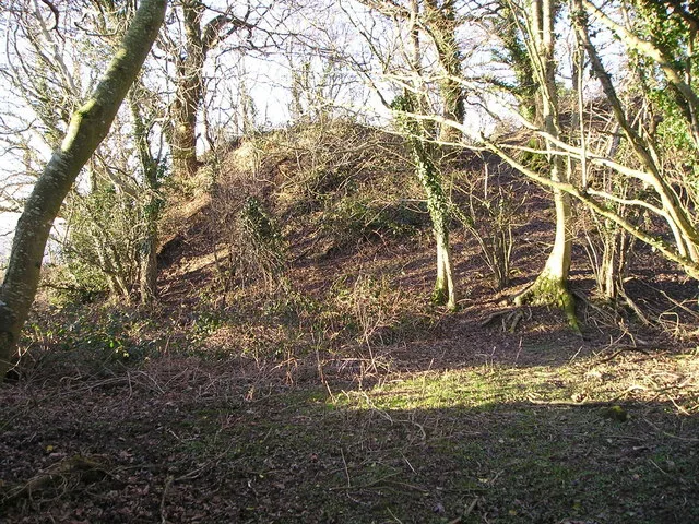
History
Pencastell is a bracken and tree-clad motte that can be seen on the hillside above Pentrecwrt. The village takes its name from the court or farmyard of the Maenor Forion Grange at Whitland. The antiquary Edward Lhuyd, described it as the abbot's summer retreat. It was established during the second half of the 12th century, when the land was granted to the Cistercian Whitland Abbey by the sons of the local Welsh lord Maredudd of Cilrhedyn. A corn mill and a fulling mill were located on the Afon Siedi at Geulan Felen, demonstrating that the abbey may have been an early pioneer of the textile industry in the area. Court Farm now stands on this site. Uphill from the village is the grange…
Sourced from Wikipedia under CC BY-SA 4.0.
- Coordinates
- 52.0208, -4.3500
- District
- Carmarthenshire
- Parish
- Llangeler
- Postcode
- SA44 5DJ
- Parliamentary constituency
- Caerfyrddin
- Nearest railway station
- Henllan High Level — 3.8 km
Sources
- wikidata: Q3400302 (CC0)
- wikipedia: Pentrecwrt (CC BY-SA 4.0)
Other places nearby

Allt-y-Cafan Bridge
Historic bridges · 0.8 km
Pentrecourt Platform railway station
Heritage railway stations · 0.8 km
Pencastell
Castles · 1.5 km

Llangeler
Villages · 1.7 km

Castell Waun-Withan
Literary houses · 1.8 km

Castell Pistog
Literary houses · 2.0 km

Bangor Teifi
Mountains & hills · 2.1 km

Y Gaer Wen
Vineyards · 2.2 km

Llangeler
Other places · 2.3 km

West Wales Museum of Childhood
Museums · 2.7 km

Amguedffa am Blentyndod Gorllewin Cymru
Museums · 2.7 km

Llandyssul railway station
Heritage railway stations · 2.8 km
Nearby
📷 5Historic bridges · Mid Wales
Allt-y-Cafan Bridge
Allt-y-Cafan Bridge — Grade II* listed building-listed bridge in wales-mid, United Kingdom.
📷 3Heritage railway stations · Mid Wales
Pentrecourt Platform railway station
Pentrecourt Platform railway station in Wales Mid, United Kingdom.
📷 3Castles · Mid Wales
Pencastell
Pencastell — possible castle in Llangeler, Carmarthenshire, Wales, UK.
📷 5📷 5Literary houses · Mid Wales
Castell Waun-Withan
Castell Waun-Withan — a literary house museum in wales mid.
📷 4Where to eat & stay near Pentrecwrt
Places to stay
 📷 5
📷 5 📷 3
📷 3Campsites · Mid Wales
Afon Teifi Caravan and Camping Park
Afon Teifi Caravan and Camping Park — a campsite in wales mid.
 📷 5
📷 5Caravan parks · Mid Wales
Moelfryn Caravan and Camping Park
Moelfryn Caravan and Camping Park — a caravan park in wales mid.
 📷 5
📷 5 📷 5
📷 5 📷 5
📷 5Places to eat & drink
 📷 3
📷 3Historic pubs · Mid Wales
The Bunch of Grapes
The Bunch of Grapes — Historic pub — listed building or notable heritage status.
 📷 3
📷 3Historic pubs · Mid Wales
The Three Horseshoes
The Three Horseshoes — Historic pub — listed building or notable heritage status.
 📷 5
📷 5Historic pubs · Mid Wales
White Hart
White Hart — Historic pub — listed building or notable heritage status.
 📷 5
📷 5 📷 3
📷 3 📷 5
📷 5More places in this region
 📷 3
📷 3Harbours & ports · Mid Wales
Aberystwyth Harbour
Aberystwyth Harbour — harbour at Aberystwyth, Ceredigion, Wales, UK.
.jpg?width=1200) 📷 3
📷 3Harbours & ports · Mid Wales
Fishguard Harbour
Fishguard Harbour is a harbour in the United Kingdom.
 📷 5
📷 5Harbours & ports · Mid Wales
New Quay Lifeboat Station
New Quay Lifeboat Station in Wales Mid, United Kingdom.
 📷 4
📷 4Frequently asked questions
- Where is Pentrecwrt?
- Pentrecwrt is in Mid Wales, United Kingdom (postcode SA44 5DJ), in the parish of Llangeler.
- What is Pentrecwrt?
- Pentrecwrt in Wales Mid, United Kingdom.
- How do I get to Pentrecwrt?
- The nearest railway station is Henllan High Level, about 3.8 km away. Drivers can use postcode SA44 5DJ.
- How do I get to Pentrecwrt?
- The nearest railway station is Henllan High Level, about 3.8 km away. Drivers can navigate to postcode SA44 5DJ.