
Historic bridges · East Midlands
Pair Of Bridges Over River Welland
In or near Marholm.
Pair Of Bridges Over River Welland — Grade II listed building-listed bridge in england-london, United Kingdom.

Alex McGregor — CC BY-SA 2.0 via Wikimedia Commons licence

Plan your visit
- Typical visit
- 15 min–30 min
- Nearest railway station
- Stamford · 8.3 km
- Free entry
- Dog-friendly
Getting there & planning your visit
To visit the Pair of Bridges Over River Welland, the nearest railway station is Stamford, located 8.3 km away. The postcode for navigation is PE6 9GP, and entry to the site is free.
About
Pair Of Bridges Over River Welland is a Grade II listed building-listed bridge in england-london, United Kingdom, registered on the National Heritage List for England (NHLE entry 1317148). Listed status protects buildings and structures of special architectural or historic interest. See the linked Wikipedia article for further details.
Photo gallery
Heritage listing
Details TF 10 NW 10/273 21.1.80 WEST DEEPING KING STREET Pair of bridges over River Welland II Pair of road bridges. Early C19. Coursed limestone rubble, with ashlar dressings. Elliptical ashlar single spans one with vermiculatred quoins and springers. Above are single narrow bands and plain parapet with square copings, terminating in splayed segmental ends. Listing NGR: TF1105608538 Legacy The contents of this record have been generated from a legacy data system. Legacy System number: 194659 Legacy System: LBS
From the Historic England List Entry under OGL v3.
Place summary
The Pair of Bridges over the River Welland is a Grade II listed building located in London. These bridges are notable for their architectural significance and historical value within the area. Their designation reflects their importance in the context of London's infrastructure.
AI-generated from the structured facts on this page (operator, designation, listing, era). Not a substitute for visiting.
- Coordinates
- 52.6633, -0.3593
- County
- Lincolnshire
- District
- South Kesteven
- Parish
- West Deeping
- Postcode
- PE6 9GP
- Parliamentary constituency
- South Holland and The Deepings
- Nearest railway station
- Stamford — 8.3 km
Sources
- wikidata: Q26603393 (CC0)
Other places nearby

Bridge Over Mill Stream About 135 Yards East North East Of Lolham Mill
Historic bridges · 0.4 km
Bridge Over Ditch About 135 Yards East South East Of Lolham Mill
Historic bridges · 0.5 km

Tallington
Historic churches · 1.6 km

Bridge Over South Drain
Historic bridges · 1.9 km

Maxey Castle
Castles · 2.0 km

Brian's Tree
Memorials & monuments · 2.1 km

Mill Race Bridge To Market Deeping Mill
Historic bridges · 2.7 km

Barholm and Stowe
Historic churches · 2.8 km

Bainton Buttercross
Memorials & monuments · 3.0 km

Settlement site E of Uffington and Barnack Station
Vineyards · 3.0 km

Torpel's Manor
Manor houses · 3.1 km
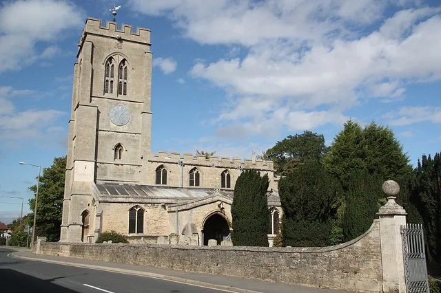
St Guthlac's Church, Market Deeping
Historic churches · 3.2 km
Nearby
📷 5Historic bridges · East Midlands
Bridge Over Mill Stream About 135 Yards East North East Of Lolham Mill
Bridge Over Mill Stream About 135 Yards East North East Of Lolham Mill — Grade II listed building-listed bridge in england-london, United Kingdom.
📷 5Historic bridges · East Midlands
Bridge Over Ditch About 135 Yards East South East Of Lolham Mill
Bridge Over Ditch About 135 Yards East South East Of Lolham Mill — Grade II listed building-listed bridge in england-london, United Kingdom.
📷 5Historic churches · East Midlands
Tallington
Tallington — a church in england-london, United Kingdom.
📷 5Historic bridges · East Midlands
Bridge Over South Drain
Bridge Over South Drain — Grade II listed building-listed bridge in england-london, United Kingdom.
📷 4Castles · East Midlands
Maxey Castle
Maxey Castle — castle, now ruinous, in Maxey, Cambridgeshire, England, UK.
📷 5Memorials & monuments · East Midlands
Brian's Tree
Brian's Tree — a memorial in england-london, United Kingdom.
Where to eat & stay near Pair Of Bridges Over River Welland
Places to stay
 📷 5
📷 5Caravan parks · East Midlands
Cresslands
Cresslands — a caravan park in england east midlands.
 📷 5
📷 5Hotels · East Midlands
George Hotel, Stamford
The George Hotel is a hotel and former coaching inn on the route of the Great North Road in St Martin's, Stamford, Lincolnshire, England. The hotel itself and numbers 68 and 69 St Martin's, which has
 📷 6
📷 6 📷 5
📷 5 📷 4
📷 4Caravan parks · East Midlands
Home Farm Camping and Caravaning
Home Farm Camping and Caravaning — a caravan park in england east midlands.
 📷 5
📷 5Campsites · East of England
Sacrewell Farm
Sacrewell Farm — a campsite in england london.
Places to eat & drink
 📷 5
📷 5Historic pubs · East of England
Blue Bell Public House
Blue Bell Public House in England East, United Kingdom.
 📷 5
📷 5Historic pubs · East of England
Ye Olde White Hart
Ye Olde White Hart in England East, United Kingdom.
 📷 5
📷 5Historic pubs · East of England
The Blue Bell Public House
The Blue Bell Public House in England East, United Kingdom.
 📷 5
📷 5Historic pubs · East Midlands
The O'Briens Arms Public House
The O'Briens Arms Public House in England East, United Kingdom.
 📷 5
📷 5Historic pubs · East Midlands
The Beehive Public House
The Beehive Public House in England East, United Kingdom.
 📷 7
📷 7More bridges in this region
📷 5Historic bridges · East Midlands
Mill Race Bridge To Market Deeping Mill
Mill Race Bridge To Market Deeping Mill — Grade II listed building-listed bridge in england-london, United Kingdom.
 📷 5
📷 5Historic bridges · East Midlands
Bridge Over West Glen River
Bridge Over West Glen River — Grade II listed building-listed bridge in england-london, United Kingdom.
 📷 5
📷 5Historic bridges · East Midlands
Bridge And Sluices
Bridge And Sluices — Grade II listed building-listed bridge in england-london, United Kingdom.
 📷 5
📷 5Historic bridges · East Midlands
Bridge Over River Gwash
Bridge Over River Gwash — Grade II listed building-listed bridge in england-london, United Kingdom.
Frequently asked questions
- Where is Pair Of Bridges Over River Welland?
- Pair Of Bridges Over River Welland is in Lincolnshire, London, United Kingdom (postcode PE6 9GP), in the parish of West Deeping.
- What is Pair Of Bridges Over River Welland?
- Pair Of Bridges Over River Welland — Grade II listed building-listed bridge in england-london, United Kingdom.
- How do I get to Pair Of Bridges Over River Welland?
- The nearest railway station is Stamford, about 8.3 km away. Drivers can use postcode PE6 9GP.
- Is Pair Of Bridges Over River Welland a listed building?
- Pair Of Bridges Over River Welland is officially recognised as Grade II listed building listed.
- Is Pair Of Bridges Over River Welland free to visit?
- Yes, Pair Of Bridges Over River Welland is free to enter.
- How do I get to Pair Of Bridges Over River Welland?
- Drivers can navigate to postcode PE6 9GP. It sits within the South Holland and The Deepings parliamentary constituency.