
National parks · North East England
Otterburn Mires
In or near Rochester.
Otterburn Mires in England North East, United Kingdom.

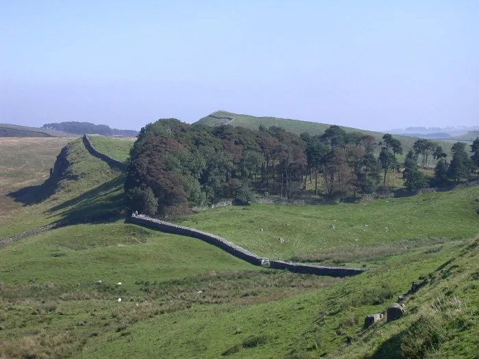
Rude Health — CC BY-SA 2.0 via Wikimedia Commons licence

Plan your visit
- Typical visit
- 4 h–8 h
- Best time of year
- Spring – autumn (Apr–Oct)
- Free entry
- Family-friendly
- Dog-friendly
About
Otterburn Mires is a place of interest in England North East, United Kingdom — drawn from open-data sources for visitor reference. See the linked Wikipedia article for the full description.
Photo gallery
Protected designations
- Site of Special Scientific Interest: Otterburn Mires SSSI
- Site of Special Scientific Interest: River Coquet and Coquet Valley Woodlands SSSI
Designations sourced from Natural England open data under OGL v3.
From the Wikipedia article
Otterburn Mires is a Site of Special Scientific Interest made up of eight separate patches of land. It is located within Northumberland National Park, in Northumberland, England, 3km east of Byrness, (east of Cottonshope burn, above Cottonshopeburnfoot). Otterburn Mires was designated as a protected area because it represents examples of several types of mire (blanket bog), still existing in Northumberland. These protected habitat patches include watershed mire (located on plateaus, and thus gains its water supply from rain) as well as spur mire and saddle mire that gain their water supply from ground water flow. Moss species in these mires include Sphagnum papillosum, Sphagnum cuspidatum, Sphagnum recurvum and Sphagnum capillifolium. Bird species recorded in this protected area include golden plover and black grouse. All of the land designated as Otterburn Mires SSSI is owned by the Ministry of Defence and is located within Otterburn Training Area (access is closed when red flags are flying).
Excerpt from Wikipedia under CC BY-SA 4.0. See the source article linked in Sources below.
- Coordinates
- 55.3379, -2.2380
Sources
- wikidata: Q131127011 (CC0)
- wikipedia: Otterburn Mires (CC BY-SA 4.0)
Other places nearby

Long Hill
Mountains & hills · 2.7 km
Northumberland National Park
National parks · 2.7 km

Roman Camp
Archaeological sites · 3.1 km

Ramsey's Burn Wood
Wildlife reserves · 3.3 km

Featherwood Roman Camps
Memorials & monuments · 3.4 km

Roman Camp
Archaeological sites · 3.8 km

Usway Burn
National parks · 4.6 km

old Linbrig Village
Archaeological sites · 4.8 km

Cottonshope Head Quarry
National parks · 4.8 km

Harbottle Moors
Wildlife reserves · 5.1 km

Bell Hill
Mountains & hills · 5.2 km

Calf Lee
Mountains & hills · 5.3 km
Nearby
📷 5Mountains & hills · North East England
Long Hill
Long Hill — a hill or mountain in scotland lowlands.
Flagship📷 4National parks · North East England
Northumberland National Park
Northumberland National Park is a National park in Northumberland, England.
📷 5Archaeological sites · North East England
Roman Camp
Roman Camp — archaeological in scotland lowlands.
📷 5Wildlife reserves · North East England
Ramsey's Burn Wood
Ramsey's Burn Wood in England North East, United Kingdom.
📷 3Memorials & monuments · North East England
Featherwood Roman Camps
Featherwood Roman Camps in England North East, United Kingdom.
📷 5Archaeological sites · North East England
Roman Camp
Roman Camp — archaeological in scotland lowlands.
Where to eat & stay near Otterburn Mires
Places to stay
 📷 5
📷 5Caravan parks · North East England
Border Forest Caravan Park
Border Forest Caravan Park — a caravan park in scotland lowlands.
 📷 5
📷 5Campsites · North East England
Firing Point - Farm
Firing Point - Farm — a campsite in scotland lowlands.
 📷 5
📷 5 📷 5
📷 5Hotels · North East England
William de Percy
William de Percy — a hotel in scotland lowlands.
 📷 5
📷 5 📷 5
📷 5Hostels · North East England
Mounthooly Bunk House
Mounthooly Bunk House — a hostel in scotland lowlands.
Places to eat & drink
 📷 5
📷 5Historic pubs · North East England
The Redesdale Arms
The Redesdale Arms in Scotland Lowlands, United Kingdom.
 📷 7
📷 7 📷 7
📷 7Historic pubs · North East England
Plough Inn With Outbuilding To North
Plough Inn With Outbuilding To North in Scotland Lowlands, United Kingdom.
 📷 7
📷 7Historic pubs · North East England
Bridge Of Aln Hotel
Bridge Of Aln Hotel in Scotland Lowlands, United Kingdom.
More national parks in this region
 📷 4
📷 4 📷 4
📷 4National parks · North East England
Mallerstang
Mallerstang in England North East, United Kingdom.
 📷 4
📷 4National parks · North East England
Kisdon Force
Kisdon Force in England North East, United Kingdom.
 📷 4
📷 4Frequently asked questions
- Where is Otterburn Mires?
- Otterburn Mires is in North-East England, United Kingdom.
- What is Otterburn Mires?
- Otterburn Mires in England North East, United Kingdom.
- How do I get to Otterburn Mires?
- The nearest town is Rochester. Its coordinates are 55.3379°, -2.2380°.
- Is Otterburn Mires a protected site?
- Yes — Otterburn Mires is part of the Otterburn Mires SSSI Site of Special Scientific Interest and the River Coquet and Coquet Valley Woodlands SSSI Site of Special Scientific Interest.
- Is Otterburn Mires free to visit?
- Yes, Otterburn Mires is free to enter.