
Towns & cities · East Midlands
Osgodby
Osgodby — village and civil parish in West Lindsey, Lincolnshire, England, UK.

Wikimedia Commons contributors — see linked file page for photographer and licence licence

Plan your visit
- Typical visit
- 3 h–6 h
- Nearest railway station
- Market Rasen · 5.3 km
- Free entry
- Family-friendly
- Dog-friendly
Getting there & planning your visit
To visit Osgodby, the nearest railway station is Market Rasen, located 5.3 km away. Entry to the town is free.
About
Osgodby is a town, city, village or settlement in the United Kingdom. Recent population estimates put it at around 579 people. Address: LN8. Wikidata describes it as: "village and civil parish in West Lindsey, Lincolnshire, England, UK". Coordinates: 53.4202°, -0.3883°.
Photo gallery
Protected designations
- Site of Special Scientific Interest: Humber Estuary - 2000480 SSSI
- Ramsar wetland: Humber Estuary
Designations sourced from Natural England open data under OGL v3.
From the Wikipedia article
Osgodby is a village and civil parish in the West Lindsey district of Lincolnshire, England. The population of the civil parish, including Kingerby, Kirkby and Usselby, as well as West Rasen in its own civil parish, was 660 at the 2011 census. Osgodby is close to the A1103 and A46 roads, and 3 miles (5 km) north-west from the market town of Market Rasen. The parish contains the small villages of Kingerby, Kirkby cum Osgodby, Osgodby itself, Usselby and the hamlet of Bishopbridge. To the north is North Owersby. Nearby to the west is the north–south River Ancholme. The population of the parish is 646.
Excerpt from Wikipedia under CC BY-SA 4.0. See the source article linked in Sources below.
Background
History
At the time of Domesday Book the village consisted of 41 households. There are medieval settlement remains, including a moat, visible as earthworks and thought to be part of Tournay Manor which was established during the 14th century. In 1424 John Tournay was given as a gift land on the south side of Osgodby, but the principal residence of the family was at Caenby. During the Second World War there was an army camp at Osgodby, and 60 accommodation huts were dispersed within nearby woodland. One building remains at the junction of the A46 – A1103, function unknown, and where the woods border the A1103, Westwards from the A46, many of the foundations are still visible.
Sourced from Wikipedia under CC BY-SA 4.0.
- Coordinates
- 53.4202, -0.3883
- County
- Lincolnshire
- District
- West Lindsey
- Parish
- Osgodby
- Postcode
- LN8
- Parliamentary constituency
- Gainsborough
- Population
- 579
- Nearest railway station
- Market Rasen — 5.3 km
Sources
- wikidata: Q608688 (CC0)
- wikipedia: Osgodby, Lincolnshire (CC BY-SA 4.0)
- commons: Bishopbridge - geograph.org.uk - 124140.jpg (CC BY-SA 4.0)
Other places nearby

Blessed Lady And St Joseph Chapel And House
Chapels · 0.4 km
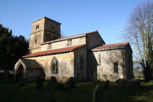
St Peter's Church, Kingerby
Historic churches · 1.5 km

Medieval castle and ecclesiastical complex, Kingerby
Castles · 1.5 km
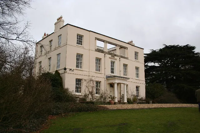
Kingerby Castle
Stately homes · 1.6 km
Kingerby Hall
Manor houses · 1.6 km

North Owersby
Villages · 2.1 km

Owersby
Historic churches · 2.1 km

Usselby
Villages · 2.7 km

West Rasen
Villages · 3.6 km

Thornton le Moor
Villages · 3.8 km

Middle Rasen
Historic churches · 4.1 km

Brockenback
Archaeological sites · 4.1 km
Osgodby is a town in Lincolnshire, located in the East Midlands. Visitors can explore Kingerby Castle, a stately home, and St Peter's Church in Kingerby. The area also features Holy Rood Church in Market Rasen and Market Rasen Racecourse, which serves as a museum.
At a glance
- Population
- 579
- Administrative county
- Lincolnshire
- Constituency
- Gainsborough
- Top categories near here
Things to see in Osgodby
41 attractions within 12 km — showing the 24 most editorially-significant. Full guide: things to do in Osgodby →
📷 3Chapels · East Midlands
Blessed Lady And St Joseph Chapel And House
Blessed Lady And St Joseph Chapel And House — chapel in Osgodby, West Lindsey, Lincolnshire, England, UK.
📷 3Stately homes · East Midlands
Kingerby Castle
Kingerby Castle — manor house in Osgodby, West Lindsey, Lincolnshire, England, UK.
 📷 3
📷 3Chapels · East Midlands
Methodist Centenary Chapel
Methodist Centenary Chapel — chapel in Market Rasen, Lincolnshire, England, UK.
📷 3Historic churches · East Midlands
St Peter's Church, Kingerby
St Peter's Church, Kingerby — church in West Lindsey, UK.
📷 3Archaeological sites · East Midlands
Brockenback
Brockenback — an archaeological site in East Midlands, United Kingdom.
📷 3📷 3Castles · East Midlands
Medieval castle and ecclesiastical complex, Kingerby
Medieval castle and ecclesiastical complex, Kingerby — scheduled monument-listed castle in england-east-midlands, United Kingdom.
 📷 3
📷 3Historic bridges · East Midlands
Old Tollgate Bridge
Old Tollgate Bridge — Grade II listed building-listed bridge in england-east-midlands, United Kingdom.
 📷 3
📷 3Historic bridges · East Midlands
Ancholme Tow Path Bridge At Tf 010990, Caistor Canal
Ancholme Tow Path Bridge At Tf 010990, Caistor Canal — Grade II listed building-listed bridge in england-east-midlands, United Kingdom.
 📷 3
📷 3Memorials & monuments · East Midlands
Market Rasen War Memorial
Market Rasen War Memorial — Grade II listed building-listed memorial in england-east-midlands, United Kingdom.
 📷 3
📷 3Memorials & monuments · East Midlands
Tower At South Kelsey Hall
Tower At South Kelsey Hall — Grade II listed building-listed memorial in england-east-midlands, United Kingdom.
 📷 5
📷 5Museums · East Midlands
Market Rasen
Market Rasen — a museum in england-east-midlands, United Kingdom.
 📷 5
📷 5Museums · East Midlands
Market Rasen Racecourse
Market Rasen Racecourse — a museum in england-east-midlands, United Kingdom.
 📷 5
📷 5Historic churches · East Midlands
2008 Market Rasen earthquake
On 27 February 2008 at 00:56:47.8s GMT an earthquake occurred at Market Rasen, Lincolnshire, England. According to the British Geological Survey the earthquake registered a reading of 5.2 on the Richt
 📷 5
📷 5Historic churches · East Midlands
Glentham
Glentham is a village and civil parish in the West Lindsey district of Lincolnshire, England. It is situated on the A631, 6 miles (9.7 km) west from Market Rasen, and 2 miles (3.2 km) east from Caenby
 📷 5
📷 5Historic churches · East Midlands
Holton le Moor
Holton le Moor — a church in england-east-midlands, United Kingdom.
📷 5Historic churches · East Midlands
Middle Rasen
Middle Rasen — a church in england-east-midlands, United Kingdom.
 📷 5
📷 5Historic churches · East Midlands
Snitterby
Snitterby — a church in england-east-midlands, United Kingdom.
📷 5Historic churches · East Midlands
Owersby
Owersby — a church in england-east-midlands, United Kingdom.
 📷 5
📷 5Historic churches · East Midlands
South Kelsey
South Kelsey is a village and civil parish in the West Lindsey district of Lincolnshire, England. It is situated on the B1205, 5 miles (8.0 km) east from the A15 and 4.5 miles (7 km) south-west from C
 📷 5
📷 5Historic churches · East Midlands
Holy Rood Church, Market Rasen
Holy Rood Catholic Church is a Roman Catholic parish church located on King Street in Market Rasen, Lincolnshire, England. The church dates from the 19th century.
 📷 5
📷 5Historic churches · East Midlands
Church of St Mary and St Peter, Waddingham
The Church of St Mary and St Peter is a church in Waddingham, Lincolnshire. It is a Grade II* listed building.
 📷 5
📷 5Historic churches · East Midlands
Waddingham
Waddingham is a village and civil parish in the West Lindsey district of Lincolnshire, England. It is geographically situated 1.5 miles (2.4 km) to the east of the A15 road, 10 miles (16 km) south-eas
 📷 5
📷 5Historic churches · East Midlands
Toft Newton
Toft Newton is a civil parish in the West Lindsey district of Lincolnshire, England. It consists of the hamlets of Toft next Newton and Newton by Toft, and the small village of Newtoft. It is 4 miles
Nearby
📷 3Chapels · East Midlands
Blessed Lady And St Joseph Chapel And House
Blessed Lady And St Joseph Chapel And House — chapel in Osgodby, West Lindsey, Lincolnshire, England, UK.
📷 3Historic churches · East Midlands
St Peter's Church, Kingerby
St Peter's Church, Kingerby — church in West Lindsey, UK.
📷 3Castles · East Midlands
Medieval castle and ecclesiastical complex, Kingerby
Medieval castle and ecclesiastical complex, Kingerby — scheduled monument-listed castle in england-east-midlands, United Kingdom.
📷 3Stately homes · East Midlands
Kingerby Castle
Kingerby Castle — manor house in Osgodby, West Lindsey, Lincolnshire, England, UK.
📷 3📷 5Where to eat & stay near Osgodby
Places to stay
 📷 5
📷 5Campsites · East Midlands
Walesby Woodlands
Walesby Woodlands — a campsite in england east midlands.
📷 5Caravan parks · East Midlands
Walesby Woodlands Caravan Park
Walesby Woodlands Caravan Park — a caravan park in england east midlands.
 📷 5
📷 5Campsites · East Midlands
Market Rasen Racecourse
Market Rasen Racecourse — a campsite in england east midlands.
 📷 5
📷 5Campsites · East Midlands
The Skipworth Arms Campsite
The Skipworth Arms Campsite — a campsite in england east midlands.
 📷 5
📷 5Campsites · East Midlands
Brandy Wharf Leisure Park
Brandy Wharf Leisure Park — a campsite in england east midlands.
 📷 5
📷 5Caravan parks · East Midlands
Nettleton Park
Nettleton Park — a caravan park in england east midlands.
Places to eat & drink
 📷 5
📷 5 📷 7
📷 7 📷 5
📷 5 📷 5
📷 5Restaurants · East Midlands
Cafe Zoot
Cafe Zoot — a restaurant in england east midlands.
 📷 5
📷 5Historic pubs · East Midlands
268, High Street
268, High Street in England East Midlands, United Kingdom.
 📷 5
📷 5Cafés · East Midlands
Madame Waffle
Madame Waffle — a café in england east midlands.
More towns in this region
 📷 5
📷 5 📷 5
📷 5Towns & cities · East Midlands
Marholm
Marholm — village and civil parish in Cambridgeshire, UK.
 📷 5
📷 5Towns & cities · East Midlands
Thornhaugh
Thornhaugh — village and civil parish in Cambridgeshire, UK.
 Flagship📷 4
Towns & cities · East Midlands
Austerfield
Austerfield — village and civil parish in South Yorkshire, England, UK.
Frequently asked questions
- Where is Osgodby?
- Osgodby is in Lincolnshire, the East Midlands, United Kingdom (postcode LN8), in the parish of Osgodby.
- What is Osgodby?
- Osgodby — village and civil parish in West Lindsey, Lincolnshire, England, UK.
- How do I get to Osgodby?
- The nearest railway station is Market Rasen, about 5.3 km away. Drivers can use postcode LN8.
- Is Osgodby a protected site?
- Yes — Osgodby is part of the Humber Estuary - 2000480 SSSI Site of Special Scientific Interest and the Humber Estuary Ramsar wetland.
- Is Osgodby free to visit?
- Yes, Osgodby is free to enter.
- How do I get to Osgodby?
- The nearest railway station is Market Rasen, about 5.3 km away. Drivers can navigate to postcode LN8.