
Historic bridges · London
North Circular Road
Also known as: An Cuarbhóthar Thuaidh, Londain (A406)
In or near Lambourne.
North Circular Road is a historic bridge in the United Kingdom.

Martin Addison — CC BY-SA 2.0 via Wikimedia Commons licence

Plan your visit
- Typical visit
- 15 min–30 min
- Nearest railway station
- Ilford · 0.5 km
- Free entry
- Dog-friendly
Getting there & planning your visit
To visit North Circular Road, the nearest railway station is Ilford, located 0.5 km away. Entry is free, and the postcode for navigation is E12 5LP.
About
North Circular Road is a named historic bridge in the United Kingdom. Coordinates: 51.5554°, 0.0657°. This entry is part of The Great Britain Guide, a free, ad-free, open-data tourist directory.
Photo gallery
See it from the streetimagery from 2025
Imagery © Mapillary contributors, CC BY-SA 4.0
From the Wikipedia article
The North Circular Road (officially the A406 and sometimes known as simply the North Circular) is a 25.7-mile-long (41.4 km) ring road around the northern half of inner London. It runs from Chiswick in the west to North Woolwich in the east via suburban north London, connecting various suburbs and other trunk roads in the region. Together with its counterpart, the South Circular Road, it mostly forms a ring road around inner London, except for crossing of the River Thames to the east, which is done by the Woolwich Ferry. The road was constructed in the Interwar period to connect local industrial communities and by pass London. It was upgraded after World War II, and was at one point planned to become a motorway as part of the controversial and ultimately cancelled London Ringways scheme. In the early 1990s, the road was extended to bypass Barking and meet the A13 north of Woolwich, though without a direct link to the ferry. The road's design varies from six-lane dual carriageway to urban streets; the latter, although short, cause traffic congestion in London and are regularly featured on local traffic reports, particularly at Bounds Green. The uncertainty of development has caused urban decay and property blight along its route, and led to criticism over its poor pollution record. Several London Borough Councils have set up regeneration projects to improve the environment for communities close to the road.
Excerpt from Wikipedia under CC BY-SA 4.0. See the source article linked in Sources below.
Background
History
Proposals for a route avoiding Central London arose during the early 20th century due to increasing levels of traffic. By 1910, the London Traffic Division of the Board of Trade had developed schemes for several new roads. This included what became the North Circular Road, which was designed to skirt the extent of urban development along suburbs. Actual construction of The North Circular Road was mostly started as an unemployment relief scheme following the First World War. Various manufacturing industries, including furniture production, had moved away from the East End in the early 20th century and started to be based in areas on the fringes of outer London development. As well as a…
Sourced from Wikipedia under CC BY-SA 4.0.
- Coordinates
- 51.5554, 0.0657
- District
- Newham
- Parish
- Newham, unparished area
- Postcode
- E12 5LP
- Parliamentary constituency
- East Ham
- Nearest railway station
- Ilford — 0.5 km
- Official site
- www.google.co.uk
Sources
- osm: w15136113 (ODbL)
- wikipedia: North Circular Road (CC BY-SA 4.0)
Other places nearby

Biograph Theatre
Theatres · 0.4 km

Ilford Hippodrome Theatre
Theatres · 0.4 km

Cinema DeLuxe
Theatres · 0.6 km

Cineworld
Cinemas · 0.6 km

Heroes of Palestine
Public art & sculpture · 0.6 km

Ilford Hindu Centre
Historic churches · 0.6 km
Mercato Metropolitano Ilford
Farmers’ markets · 0.6 km

Ilford Central Mosque
Historic churches · 0.6 km
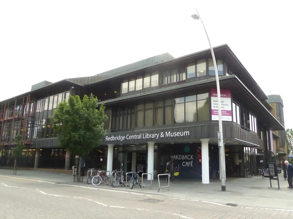
Redbridge Museum
Museums · 0.7 km

Kenneth More Theatre
Open-air theatres · 0.7 km

Kenneth More Theatre
Theatres · 0.7 km

Sri Rajarajeshwari Amman Temple
Historic churches · 0.8 km
Nearby
📷 5Theatres · London
Biograph Theatre
Biograph Theatre in England London, United Kingdom.
📷 5Theatres · London
Ilford Hippodrome Theatre
Ilford Hippodrome Theatre in England London, United Kingdom.
📷 5Theatres · London
Cinema DeLuxe
Cinema DeLuxe in England London, United Kingdom.
📷 5📷 5Public art & sculpture · London
Heroes of Palestine
Heroes of Palestine — a public art in england-london, United Kingdom.
📷 5Historic churches · London
Ilford Hindu Centre
Ilford Hindu Centre — a church in england-london, United Kingdom.
Where to eat & stay near North Circular Road
Places to stay
 📷 7
📷 7 📷 5
📷 5 📷 5
📷 5 📷 5
📷 5Hotels · London
The Westbridge Hotel
The Westbridge Hotel — a hotel in england london.
 📷 7
📷 7Hotels · London
The Stratford Hotel
The Stratford Hotel — a hotel in england london.
 📷 5
📷 5Hotels · London
Hyatt Regency London Stratford
Hyatt Regency London Stratford — a hotel in england london. 5-star. Brand: Hyatt Regency.
Places to eat & drink
 📷 7
📷 7 📷 7
📷 7Historic pubs · London
Denmark Arms
Denmark Arms in England London, United Kingdom.
 📷 7
📷 7 📷 7
📷 7Historic pubs · London
The Boleyn
The Boleyn — Historic pub — listed building or notable heritage status.
 📷 5
📷 5Historic pubs · London
The Nightingale Public House
The Nightingale Public House in England London, United Kingdom.
 📷 7
📷 7Historic pubs · London
King Edward VII, Stratford
King Edward VII, Stratford in England London, United Kingdom.
More bridges in this region
 📷 5
📷 5 📷 5
📷 5Historic bridges · London
Albert Bridge
Albert Bridge is a historic bridge in the United Kingdom.
 📷 5
📷 5Historic bridges · London
Arnos Park Viaduct
Arnos Park Viaduct is a historic bridge in the United Kingdom.
 📷 5
📷 5Historic bridges · London
Barnes Bridge
Barnes Bridge is a historic bridge in the United Kingdom.
Frequently asked questions
- Where is North Circular Road?
- North Circular Road is in London, United Kingdom (postcode E12 5LP), in the parish of Newham, unparished area.
- What is North Circular Road?
- North Circular Road is a historic bridge in the United Kingdom.
- How do I get to North Circular Road?
- The nearest railway station is Ilford, about 0.5 km away. The nearest town is Lambourne. Drivers can use postcode E12 5LP.
- Is North Circular Road free to visit?
- Yes, North Circular Road is free to enter.
- How do I get to North Circular Road?
- The nearest railway station is Ilford, about 0.5 km away. Drivers can navigate to postcode E12 5LP.