Mountains & hills · North Wales
Mynydd y Garn
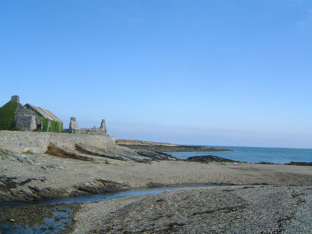
Mynydd y Garn — Named summit at 170 m.

Wikimedia Commons contributors — see linked file page for photographer and licence licence
Plan your visit
- Typical visit
- 3 h–8 h
- Best time of year
- Late spring – early autumn (May–Oct)
- Free entry
- Dog-friendly
About
Mynydd y Garn is a named summit in the United Kingdom. Wikidata describes it as: "Named summit at 170 m.". Coordinates: 53.3860°, -4.5353°.
Photo gallery
From the Wikipedia article
Mynydd y Garn is a hill in the northwest of the Isle of Anglesey in north Wales. Its 170 m (560 ft) high summit is crowned by a trig point and a stone obelisk. Erected in 1897 it commemorates Sir William Thomas, ship-owner and one time High Sheriff of Anglesey.
Excerpt from Wikipedia under CC BY-SA 4.0. See the source article linked in Sources below.
Background
Visiting
The summit area of the hill is owned by the National Trust and thereby open to free public access on foot. A couple of public footpaths run across its western slopes but access to the summit is gained from a minor road to its west by a short permissive path.
Sourced from Wikipedia under CC BY-SA 4.0.
- Coordinates
- 53.3860, -4.5353
- District
- Isle of Anglesey
- Parish
- Cylch-y-Garn
- Postcode
- LL65 4LU
- Parliamentary constituency
- Ynys Môn
Sources
- osm: n3497045993 (ODbL)
- wikipedia: Mynydd y Garn (CC BY-SA 4.0)
- commons: Mynydd y Garn, Anglesey - geograph.org.uk - 49640.jpg (CC BY-SA 4.0)
Other places nearby
Loading nearby places…
Nearby
 📷 3
📷 3Memorials & monuments · North Wales
William Thomas Monument
William Thomas Monument — a memorial in wales-north, United Kingdom.
 📷 5
📷 5Historic churches · North Wales
Cylch-y-Garn
Cylch-y-Garn is a community in Anglesey, Wales, located on the north west coast of the county, 9.0 miles (14.5 km) west of Amlwch, 12.5 miles (20.1 km) north east of Holyhead and 15.0 miles (24.1 km)
 📷 5
📷 5Historic churches · North Wales
St Mary's Church
St Mary's Church — church in Llanfair-yng-Nghornwy, Wales.
 📷 5
📷 5Historic churches · North Wales
Llanfair-yng-Nghornwy
Llanfair-yng-Nghornwy (, also spelt Llanfairynghornwy) is a village in Anglesey, in north-west Wales. A sparsely populated parish, it contains two well known geographical features; Carmel Head and, of
 📷 3
📷 3Castles · North Wales
Castell Rhonyn
Castell Rhonyn — a castle in wales-north, United Kingdom.
 📷 5
📷 5Literary houses · North Wales
Castell Crwn
Castell Crwn — a literary house museum in wales north.
Where to eat & stay near Mynydd y Garn
Places to stay
 📷 5
📷 5Campsites · North Wales
Gadlys Coastal Holiday Cottages
Gadlys Coastal Holiday Cottages — a campsite in wales north.
 📷 5
📷 5Campsites · North Wales
Ty Newydd
Ty Newydd — a campsite in wales north.
 📷 5
📷 5Campsites · North Wales
Penrhyn Bay Caravan Park
Penrhyn Bay Caravan Park — a campsite in wales north.
 📷 5
📷 5Caravan parks · North Wales
Dronwy Caravan Park
Dronwy Caravan Park — a caravan park in wales north.
 📷 5
📷 5Caravan parks · North Wales
The Ring
The Ring — a caravan park in wales north.
 📷 5
📷 5Caravan parks · North Wales
Trearddur Bay Country Park
Trearddur Bay Country Park — a caravan park in wales north.

More mountains in this region
 📷 5
📷 5Mountains & hills · North Wales
Cemlyn Bay and lagoon
Cemlyn Bay and lagoon — Site of Special Scientific Interest in Wales.
 📷 3
📷 3Mountains & hills · North Wales
Aberffraw Bay
Aberffraw Bay — bay on the west coast of Anglesey, in Wales, UK.
 📷 3
📷 3Mountains & hills · North Wales
Allt-fawr
Allt-fawr — Named summit at 698 m.
 📷 3
📷 3Mountains & hills · North Wales
Aran Benllyn
Aran Benllyn — Named summit at 884 m.
Frequently asked questions
- Where is Mynydd y Garn?
- Mynydd y Garn is in North Wales, United Kingdom (postcode LL65 4LU), in the parish of Cylch-y-Garn.
- What is Mynydd y Garn?
- Mynydd y Garn — Named summit at 170 m.
- How do I get to Mynydd y Garn?
- Drivers can use postcode LL65 4LU.
- Is Mynydd y Garn free to visit?
- Yes, Mynydd y Garn is free to enter.
- How do I get to Mynydd y Garn?
- Drivers can navigate to postcode LL65 4LU. It sits within the Ynys Môn parliamentary constituency.