Harbours & ports · South West England
Mullion Harbour
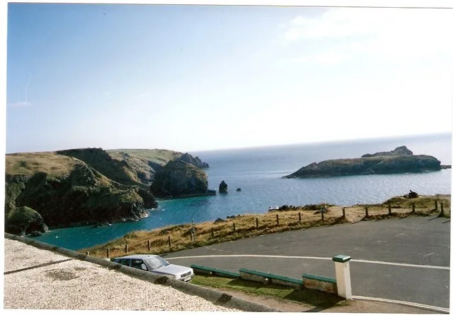
Mullion Harbour — a harbour in england south west.

David Medcalf — CC BY-SA 2.0 via Wikimedia Commons licence
Plan your visit
- Typical visit
- 45 min–1.5 h
About
Mullion Harbour is a named harbour in england south west, recorded in the GeoNames UK gazetteer. British landmarks of this type are typically marked on Ordnance Survey maps and recorded in the national gazetteer for cartographic and navigational reference. Coordinates and feature classification are sourced from the GeoNames open dataset.
Photo gallery
Place summary
Mullion Harbour is a small harbour located in South-West England. It serves as a picturesque inlet, primarily used by local fishing boats. The harbour is known for its rugged coastal scenery and provides access to the surrounding area’s natural beauty. Visitors can expect a tranquil setting, ideal for walking and observing marine activities.
AI-generated from the structured facts on this page (operator, designation, listing, era). Not a substitute for visiting.
- Coordinates
- 50.0150, -5.2586
Sources
- manual: geonames-11103032 (CC BY 4.0)
Other places nearby
Loading nearby places…
Nearby
 📷 5
📷 5Hotels · South West England
Mullion Cove Hotel
Mullion Cove Hotel — a hotel in england south west.
 📷 5
📷 5Mountains & hills · South West England
The Vro
The Vro — a hill or mountain in england south west.
 📷 5
📷 5Islands · South West England
Mullion Island
Mullion Island — island in Cornwall, United Kingdom.
 📷 5
📷 5Beaches · South West England
Pedn-y-ke
Pedn-y-ke is a beach in the United Kingdom.
 📷 5
📷 5Campsites · South West England
Teneriffe Farm Campsite
Teneriffe Farm Campsite — a campsite in england south west.
 📷 5
📷 5Memorials & monuments · South West England
Marconi Monument
Marconi Monument is a memorial in the United Kingdom.
Where to eat & stay near Mullion Harbour
Places to stay
📷 5Hotels · South West England
Mullion Cove Hotel
Mullion Cove Hotel — a hotel in england south west.
📷 5Campsites · South West England
Teneriffe Farm Campsite
Teneriffe Farm Campsite — a campsite in england south west.
 📷 5
📷 5Caravan parks · South West England
Lizard Point Holiday Park
Lizard Point Holiday Park — a caravan park in england south west. 4-star. Brand: Parkdean Resorts.
 📷 5
📷 5Campsites · South West England
Higher Bochym Campsite
Higher Bochym Campsite — a campsite in england south west.
📷 5Campsites · South West England
Bochym Pasture
Bochym Pasture — a campsite in england south west.
 📷 5
📷 5Campsites · South West England
Franchis Holiday Park
Franchis Holiday Park — a campsite in england south west.
Places to eat & drink
 📷 5
📷 5Cafés · South West England
The Stables
The Stables — a café in england south west.
 📷 5
📷 5Historic pubs · South West England
Fitzsimmons Arms Public House
Fitzsimmons Arms Public House in England South West, United Kingdom.
 📷 5
📷 5Historic pubs · South West England
The Pendarves Arms
The Pendarves Arms in England South West, United Kingdom.
 📷 5
📷 5Historic pubs · South West England
The Famous Barrel Public House
The Famous Barrel Public House in England South West, United Kingdom.
 📷 3
📷 3Historic pubs · South West England
Seven Stars
Seven Stars — Historic pub — listed building or notable heritage status.
 📷 5
📷 5Historic pubs · South West England
Kings Arms
Kings Arms — Historic pub — listed building or notable heritage status.
More places in this region
 📷 5
📷 5Harbours & ports · South West England
Axmouth harbour
Axmouth harbour — harbour at Axmouth, Devon, England, UK.
 📷 5
📷 5Harbours & ports · South West England
Brixham Harbour
Brixham Harbour — harbour and fishing port in Devon, England.
 📷 5
📷 5Harbours & ports · South West England
Carrick Roads
Carrick Roads — estuary in Cornwall, England, UK.
.jpg?width=1200) 📷 5
📷 5Harbours & ports · South West England
Clovelly harbour
Clovelly harbour — harbour in Devon, UK.
Frequently asked questions
- Where is Mullion Harbour?
- Mullion Harbour is in South-West England, United Kingdom.
- What is Mullion Harbour?
- Mullion Harbour — a harbour in england south west.
- How do I get to Mullion Harbour?
- Its coordinates are 50.0150°, -5.2586°.