
Mountains & hills · Scottish Islands
Muckle Ward
In or near Scalloway.
Muckle Ward — mountain in scotland islands. Elevation: 102 m.

Ruth Sharville — CC BY-SA 2.0 via Wikimedia Commons licence

Plan your visit
- Typical visit
- 3 h–8 h
- Best time of year
- Late spring – early autumn (May–Oct)
- Dog-friendly
About
Muckle Ward is a mountain located in scotland islands. Elevation: 102 m. A named British peak recorded in OpenStreetMap. Peaks are typically named on Ordnance Survey 1:50k mapping.
Photo gallery
Place summary
Muckle Ward is a mountain located in the Scottish Islands. It is known for its distinctive topography and natural beauty. Visitors can expect rugged landscapes typical of the region, offering opportunities for hiking and exploration. The mountain's remote setting provides a tranquil environment, ideal for those seeking solitude in nature.
AI-generated from the structured facts on this page (operator, designation, listing, era). Not a substitute for visiting.
- Coordinates
- 60.2047, -1.4106
- District
- Shetland Islands
- Postcode
- ZE2 9NH
- Parliamentary constituency
- Orkney and Shetland
Sources
- osm: n13382172837 (ODbL)
Other places nearby

Mouldy Hill
Mountains & hills · 0.7 km
Seli Voe
Natural landmarks · 0.8 km

Foglatougs
Mountains & hills · 1.2 km

Garderhouse Hill
Mountains & hills · 1.4 km
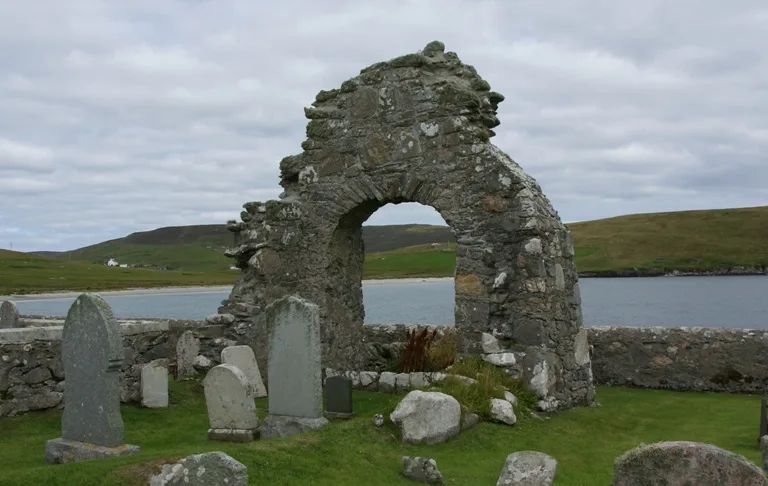
St Mary's Chapel (Sand)
Historic churches · 1.9 km

Sand
Villages · 2.1 km

Ward of Reawick
Mountains & hills · 2.1 km
Ward of Reawick
Mountains & hills · 2.2 km
Sand Field
Mountains & hills · 2.2 km

Reawick beach
Beaches · 2.2 km
Sand Field
Mountains & hills · 2.2 km

Reawick Congregational Church
Historic churches · 2.3 km
Nearby
📷 5Mountains & hills · Scottish Islands
Mouldy Hill
Mouldy Hill — mountain in scotland islands. Elevation: 89 m.
📷 5📷 5📷 5Mountains & hills · Scottish Islands
Garderhouse Hill
Garderhouse Hill — mountain in scotland islands. Elevation: 120 m.
📷 3Historic churches · Scottish Islands
St Mary's Chapel (Sand)
St Mary's Chapel (Sand) — church in Shetland Islands, Scotland, UK.
📷 5Where to eat & stay near Muckle Ward
Places to stay
 📷 5
📷 5Campsites · Scottish Islands
Skeld Caravan Park and Campsite
Skeld Caravan Park and Campsite — a campsite in scotland islands.
 📷 5
📷 5Caravan parks · Scottish Islands
Scalloway Caravan Park
Scalloway Caravan Park — a caravan park in scotland islands.
 📷 5
📷 5Campsites · Scottish Islands
South Nesting
South Nesting — a campsite in scotland islands.
 📷 5
📷 5Hostels · Scottish Islands
Islesburgh House Hostel
Islesburgh House Hostel — a hostel in scotland islands.
Caravan parks · Scottish Islands
Bressay Marina & Caravan Park
Bressay Marina & Caravan Park — a caravan park in scotland islands.
 📷 5
📷 5Places to eat & drink
 📷 7
📷 7Historic pubs · Scottish Islands
86 Commercial Street, Lerwick
86 Commercial Street, Lerwick in England South East, United Kingdom.
 📷 5
📷 5Historic pubs · Scottish Islands
Busta House Hotel, Brae
Busta House Hotel, Brae in England South East, United Kingdom.
More mountains in this region
 📷 3
📷 3Mountains & hills · Scottish Islands
Acairseid Mhor
Acairseid Mhor — bay in Outer Hebrides, Scotland, UK.
 📷 3
📷 3Mountains & hills · Scottish Islands
Ainshval
Ainshval — Named summit at 781 m.
 📷 3
📷 3 📷 5
📷 5Mountains & hills · Scottish Islands
An Cliseam
An Cliseam — Named summit at 799 m.
Frequently asked questions
- Where is Muckle Ward?
- Muckle Ward is in the Scottish Islands, United Kingdom (postcode ZE2 9NH).
- What is Muckle Ward?
- Muckle Ward — mountain in scotland islands. Elevation: 102 m.
- How do I get to Muckle Ward?
- The nearest town is Scalloway. Drivers can use postcode ZE2 9NH.
- How do I get to Muckle Ward?
- Drivers can navigate to postcode ZE2 9NH. It sits within the Orkney and Shetland parliamentary constituency.