Mountains & hills · North Wales
Moel Cynghorion
In or near Q1638504.
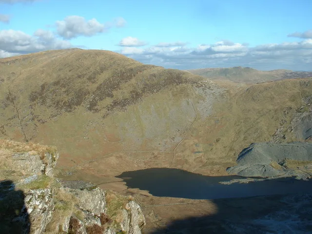
Moel Cynghorion — Named summit at 674 m.

Wikimedia Commons contributors — see linked file page for photographer and licence licence
Plan your visit
- Typical visit
- 3 h–8 h
- Best time of year
- Late spring – early autumn (May–Oct)
- Nearest railway station
- Halfway · 1.6 km
- Free entry
- Dog-friendly
Getting there & planning your visit
To visit Moel Cynghorion, the nearest railway station is Halfway, located 1.6 km away. Entry to the site is free. The postcode for navigation is LL55 4SS.
About
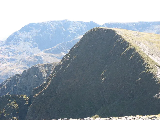
Moel Cynghorion is a named summit in the United Kingdom. Wikidata describes it as: "Named summit at 674 m.". Coordinates: 53.0854°, -4.1133°.
Photo gallery
From the Wikipedia article
Moel Cynghorion (Welsh for 'the Hill of the Councillors') is a mountain in Snowdonia, North Wales. It lies two miles north-west of Snowdon, and forms part of the Moel Eilio Horseshoe walk. The summit is situated on a wide plateau, marked by a pile of stones. The southern slopes are gentle, while the northern aspect is precipitous. The summit has close views of Clogwyn Du'r Arddu and Snowdon (Yr Wyddfa). Views from the summit can extend as far as Holyhead in Anglesey to nearby towns and villages in Gwynedd such as Caernarfon, Llanrug and Llanberis. On a clear day the Wicklow Mountains in Ireland can be seen across the Irish Sea, at a distance of approximately 80 miles.
Excerpt from Wikipedia under CC BY-SA 4.0. See the source article linked in Sources below.
- Coordinates
- 53.0854, -4.1133
- District
- Gwynedd
- Parish
- Llanberis
- Postcode
- LL55 4SS
- Parliamentary constituency
- Dwyfor Meirionnydd
- Nearest railway station
- Halfway — 1.6 km
Sources
- osm: n333563000 (ODbL)
- wikipedia: Moel Cynghorion (CC BY-SA 4.0)
- commons: Cyngortfu.jpg (CC BY-SA 4.0)
Other places nearby

Clogwyn Llechwedd-Llo
Mountains & hills · 0.3 km

Cwm Brwynog Deserted Rural Settlement
Vineyards · 0.9 km

Llyn Ffynnon y Gwas
Reservoirs & lochs · 1.1 km

Helfa Fawr
Hostels · 1.2 km

Clogwyn Du'r Arddu Far West Buttress
Climbing & bouldering crags · 1.2 km

Cefn Drum
Mountains & hills · 1.4 km
Foel Goch
Mountains & hills · 1.5 km

Clogwyn Du'r Arddu West Buttress
Climbing & bouldering crags · 1.6 km

Clogwyn Coch Copper Mines
Archaeological sites · 1.9 km
Tryfan
Mountains & hills · 1.9 km
Llechog
Mountains & hills · 2.1 km

Derlwyn
Mountains & hills · 2.3 km
Nearby
📷 5Mountains & hills · North Wales
Clogwyn Llechwedd-Llo
Clogwyn Llechwedd-Llo — mountain in wales north. Elevation: 600 m.
📷 5Vineyards · North Wales
Cwm Brwynog Deserted Rural Settlement
Cwm Brwynog Deserted Rural Settlement — a UK vineyard in wales north, producing English or Welsh wine from cool-climate grape varieties.
📷 3Reservoirs & lochs · North Wales
Llyn Ffynnon y Gwas
Llyn Ffynnon y Gwas — lake in Gwynedd, Wales.
📷 5📷 5Climbing & bouldering crags · North Wales
Clogwyn Du'r Arddu Far West Buttress
Clogwyn Du'r Arddu Far West Buttress — a climbing crag in wales north.
📷 5Where to eat & stay near Moel Cynghorion
Places to stay
📷 5 📷 5
📷 5 📷 5
📷 5 📷 5
📷 5Campsites · North Wales
Cwellyn Arms Campsite
Cwellyn Arms Campsite — a campsite in wales north.
📷 5📷 5Places to eat & drink
 📷 5
📷 5 📷 7
📷 7Restaurants · North Wales
Tafarn Tryfan
Tafarn Tryfan — a restaurant in wales north.
 📷 5
📷 5 📷 6
📷 6 📷 5
📷 5 📷 5
📷 5More mountains in this region
 📷 5
📷 5Mountains & hills · North Wales
Cemlyn Bay and lagoon
Cemlyn Bay and lagoon — Site of Special Scientific Interest in Wales.
 📷 3
📷 3Mountains & hills · North Wales
Aberffraw Bay
Aberffraw Bay — bay on the west coast of Anglesey, in Wales, UK.
 📷 3
📷 3 📷 3
📷 3Mountains & hills · North Wales
Aran Benllyn
Aran Benllyn — Named summit at 884 m.
Frequently asked questions
- Where is Moel Cynghorion?
- Moel Cynghorion is in North Wales, United Kingdom (postcode LL55 4SS), in the parish of Llanberis.
- What is Moel Cynghorion?
- Moel Cynghorion — Named summit at 674 m.
- How do I get to Moel Cynghorion?
- The nearest railway station is Halfway, about 1.6 km away. Drivers can use postcode LL55 4SS.
- Is Moel Cynghorion free to visit?
- Yes, Moel Cynghorion is free to enter.
- How do I get to Moel Cynghorion?
- The nearest railway station is Halfway, about 1.6 km away. Drivers can navigate to postcode LL55 4SS.