
Castles · North West England
Milnrow
In or near Wardle.
Milnrow is a town within the Metropolitan Borough of Rochdale, in Greater Manchester, England. It lies on the River Beal at the foothills of the South Pennines, and forms a continuous urban area with

Bryan Tenny — CC BY-SA 2.0 via Wikimedia Commons licence

Plan your visit
- Typical visit
- 1.5 h–3 h
- Nearest railway station
- Smithy Bridge · 2.5 km
- Family-friendly
- Limited wheelchair access
Getting there & planning your visit
To visit Milnrow Castle, the nearest railway station is Smithy Bridge, located 2.5 km away. The postcode for sat-nav is OL16 4HG. Please note that accessibility is limited for wheelchair users.
About
Milnrow is a town within the Metropolitan Borough of Rochdale, in Greater Manchester, England. It lies on the River Beal at the foothills of the South Pennines, and forms a continuous urban area with Rochdale. It is 2 miles (3.2 km) east of Rochdale town centre, 10 miles (16.1 km) north-northeast of Manchester, and spans from Windy Hill in the east to the Rochdale Canal in the west. Milnrow is adjacent to junction 21 of the M62 motorway, and includes the village of Newhey, and hamlets at Tunshill and Ogden. Historically in Lancashire, Milnrow during the Middle Ages was one of several hamlets in the township of Butterworth and parish of Rochdale. The settlement was named by the Anglo-Saxons, but the Norman conquest of England resulted in its ownership by minor Norman families, such as the Schofields and Cleggs. In the 15th century, their descendants successfully agitated for a chapel of ease by the banks of the River Beal, triggering its development as the main settlement in Butterworth. Milnrow was primarily used for marginal hill farming during the Middle Ages, and its population did not increase much until the dawn of the woollen trade in the 17th century. With the development of packhorse routes to emerging woollen markets in Yorkshire, the inhabitants of Milnrow adopted the domestic system, supplementing their income by fellmongering and producing flannel in their weavers' cottages. Coal mining and metalworking also flourished in the Early Modern period, and the farmers,
Photo gallery
See it from the streetimagery from 2025
Imagery © Mapillary contributors, CC BY-SA 4.0
Protected designations
- Site of Special Scientific Interest: Rochdale Canal SSSI
- Site of Special Scientific Interest: South Pennine Moors SSSI
Designations sourced from Natural England open data under OGL v3.
From the Wikipedia article
Milnrow is a town within the Metropolitan Borough of Rochdale, in Greater Manchester, England. It lies on the River Beal at the foothills of the South Pennines, and forms a continuous urban area with Rochdale. It is 2 miles (3.2 km) east of Rochdale town centre, 10 miles (16.1 km) north-northeast of Manchester, and spans from Windy Hill in the east to the Rochdale Canal in the west. Milnrow is adjacent to junction 21 of the M62 motorway, and includes the village of Newhey, and hamlets at Tunshill and Ogden. Historically in Lancashire, Milnrow during the Middle Ages was one of several hamlets in the township of Butterworth and parish of Rochdale. The settlement was named by the Anglo-Saxons, but the Norman conquest of England resulted in its ownership by minor Norman families, such as the Schofields and Cleggs. In the 15th century, their descendants successfully agitated for a chapel of ease by the banks of the River Beal, triggering its development as the main settlement in Butterworth. Milnrow was primarily used for marginal hill farming during the Middle Ages, and its population did not increase much until the dawn of the woollen trade in the 17th century. With the development of packhorse routes to emerging woollen markets in Yorkshire, the inhabitants of Milnrow adopted the domestic system, supplementing their income by fellmongering and producing flannel in their weavers' cottages. Coal mining and metalworking also flourished in the Early Modern period, and the farmers, colliers and weavers formed a "close-knit population of independent-minded workers". The hamlets of Butterworth coalesced around the commercial and ecclesiastical centre in Milnrow as demand for the area's flannel grew. In the 19th century, the Industrial Revolution supplanted domestic woollen industries and converted the area into a mill town, with cotton spinning as the principal industry. Mass-produced textile goods from Milnrow's cotton mills were exported globally with the arrival of the r
Excerpt from Wikipedia under CC BY-SA 4.0. See the source article linked in Sources below.
Background
History
The earliest evidence of human activity comes from the Mesolithic peoples, who left thousands of flint tools on the moorland surrounding Milnrow. A hunter-gatherer site was excavated by the Piethorne Brook in 1982, revealing a Mesolithic camp from which deer were hunted. Neolithic activity is evidenced with a flint axe found at Newhey and a black stone axe found by Hollingworth Lake.|group=note}} They imply the presence of Celtic Britons. Remains of a silver statue of the Roman goddess Victoria and Roman coins were discovered at Tunshill Farm in 1793, and it is surmised that Romans traversed this area in communication with the Castleshaw Roman Fort. in the rural Piethorne Valley. Livestock…
Sourced from Wikipedia under CC BY-SA 4.0.
- Coordinates
- 53.6101, -2.1111
- District
- Rochdale
- Parish
- Rochdale, unparished area
- Postcode
- OL16 4HG
- Parliamentary constituency
- Rochdale
- Nearest railway station
- Smithy Bridge — 2.5 km
Sources
- wikipedia: Milnrow (CC BY-SA 4.0)
Other places nearby

Milnrow War Memorial
Memorials & monuments · 0.9 km

Ellenroad Steam Museum
Museums · 1.0 km
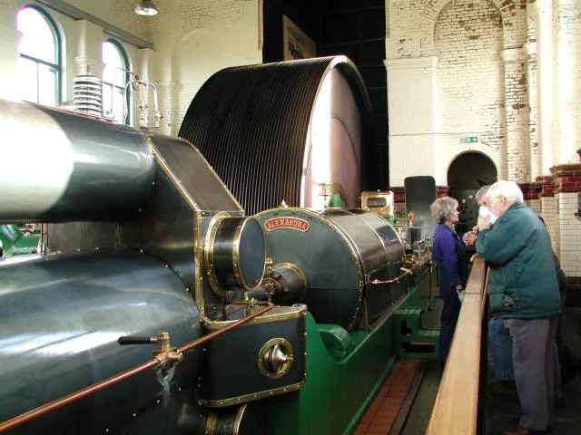
Ellenroad Ring Mill Engine
Museums · 1.0 km

Hollingworth Lake
Lakes · 1.0 km

Rochdale Canal Coppy Bridge
Historic bridges · 1.3 km

Newhey
Historic churches · 1.4 km

Moy Hill
Mountains & hills · 1.5 km

Low House Fold
Mountains & hills · 1.6 km

Belfield Bridge
Historic bridges · 1.7 km

Heights Barn Hill
Mountains & hills · 1.8 km

Moss Gate
Mountains & hills · 2.1 km
Moss Gate
Mountains & hills · 2.1 km
Nearby
📷 3Memorials & monuments · North West England
Milnrow War Memorial
Milnrow War Memorial — Grade II listed building-listed memorial in england-north-west, United Kingdom.
📷 3Museums · North West England
Ellenroad Steam Museum
Ellenroad Steam Museum — a museum in North West England, United Kingdom.
📷 3Museums · North West England
Ellenroad Ring Mill Engine
Ellenroad Ring Mill Engine — stationary steam engine and museum in Milnrow, Rochdale, Greater Manchester, England, UK.
📷 5📷 3Historic bridges · North West England
Rochdale Canal Coppy Bridge
Rochdale Canal Coppy Bridge — Grade II listed building-listed bridge in england-north-west, United Kingdom.
📷 5Historic churches · North West England
Newhey
Newhey (archaically New Hey) is a village in the town of Milnrow in the Metropolitan Borough of Rochdale, in Greater Manchester, England. It lies at the foot of the South Pennines, by Junction 21 of t
Where to eat & stay near Milnrow
Places to stay
 📷 5
📷 5Caravan parks · North West England
Hollingworth Lake Caravan park
Hollingworth Lake Caravan park — a caravan park in england north west.
 📷 5
📷 5Caravan parks · North West England
Roch Vale Caravan Park
Roch Vale Caravan Park — a caravan park in england north west.
 📷 5
📷 5Hotels · North West England
Broadfield Park Hotel
Broadfield Park Hotel — a hotel in england north west.
 📷 5
📷 5Campsites · North West England
Dog Hill Scout Campsite
Dog Hill Scout Campsite — a campsite in england north west.
 📷 5
📷 5Caravan parks · North West England
The Moorlands
The Moorlands — a caravan park in england north west.
 📷 5
📷 5Hotels · North West England
Norton Grange Hotel
Norton Grange Hotel — a hotel in england north west.
Places to eat & drink
 📷 5
📷 5 📷 7
📷 7Historic pubs · North West England
The Baum
The Baum in England North West, United Kingdom.
 📷 7
📷 7 📷 5
📷 5 📷 5
📷 5Historic pubs · North West England
Ye Olde Boars Head Public House
Ye Olde Boars Head Public House in England North West, United Kingdom.
 📷 5
📷 5Historic pubs · North West England
Colliers Arms Public House
Colliers Arms Public House in England North West, United Kingdom.
More castles in this region
 📷 3
📷 3Castles · North West England
Manchester Castle
Manchester Castle — medieval fortified manor house in England.
 📷 5
📷 5Castles · North West England
Mow Cop Castle
Mow Cop Castle — folly on the Cheshire and Staffordshire border, England, UK.
 📷 3
📷 3 📷 3
📷 3Castles · North West England
Ullerwood Castle
Ullerwood Castle — castle in Greater Manchester, England.
Frequently asked questions
- Where is Milnrow?
- Milnrow is in North-West England, United Kingdom (postcode OL16 4HG), in the parish of Rochdale, unparished area.
- What is Milnrow?
- Milnrow is a town within the Metropolitan Borough of Rochdale, in Greater Manchester, England. It lies on the River Beal at the foothills of the South Pennines, and forms a continuous urban area with
- How do I get to Milnrow?
- The nearest railway station is Smithy Bridge, about 2.5 km away. The nearest town is Wardle. Drivers can use postcode OL16 4HG.
- Is Milnrow a protected site?
- Yes — Milnrow is part of the Rochdale Canal SSSI Site of Special Scientific Interest and the South Pennine Moors SSSI Site of Special Scientific Interest.
- Does Milnrow charge admission?
- Milnrow typically charges admission. Check the official site for current ticket prices and opening hours.
- How do I get to Milnrow?
- The nearest railway station is Smithy Bridge, about 2.5 km away. Drivers can navigate to postcode OL16 4HG.