
Museums · South East England
Merstham
In or near Netherne-on-the-Hill.
Merstham is a town in the borough of Reigate and Banstead in Surrey, England. It lies 17 miles south of Charing Cross just beyond the Greater London border. Part of the North Downs Way runs along the

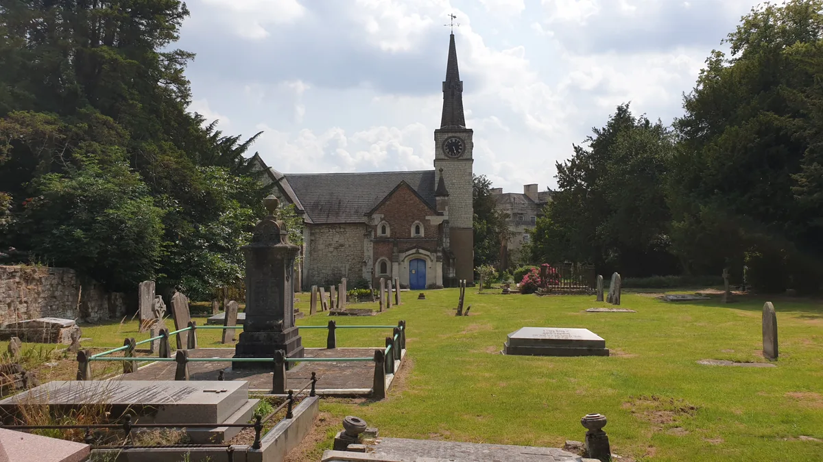
Stephen McKay — CC BY-SA 2.0 via Wikimedia Commons licence

Plan your visit
- Typical visit
- 1.5 h–3 h
- Best time of year
- Year-round
- Nearest railway station
- Merstham · 0.2 km
- Family-friendly
- Limited wheelchair access
About
Merstham is a town in the borough of Reigate and Banstead in Surrey, England. It lies 17 miles south of Charing Cross just beyond the Greater London border. Part of the North Downs Way runs along the northern boundary of the town. Merstham has community associations, an early medieval church and a football club.
Photo gallery
Protected designations
- Area of Outstanding Natural Beauty: Surrey Hills
Designations sourced from Natural England open data under OGL v3.
From the Wikipedia article
Merstham is a town in the borough of Reigate and Banstead in Surrey, England. It lies 17 miles south of Charing Cross just beyond the Greater London border. Part of the North Downs Way runs along the northern boundary of the town. Merstham has community associations, an early medieval church and a football club.
Excerpt from Wikipedia under CC BY-SA 4.0. See the source article linked in Sources below.
Background
History
The area has been settled since pre-Roman times. The village lay within the Reigate hundred, an Anglo-Saxon administrative division. Its name was recorded in 947 as Mearsætham, which seems to be Anglo-Saxon Mearþ-sǣt-hām = "Homestead near a trap set for martens or weasels". The Anglo-Saxon Chronicle for 851 states that a Viking army 'went south over the Thames into Surrey; and King Aethelwulf and his son Aethelbald with the West Saxon army fought against them at Aclea, and there made the greatest slaughter of a heathen raiding-army that we have heard tell of up to the present day, and there took the victory.' According to Stenton, the name Aclea nearly always appears in modern times as…
Description
After World War II the London County Council built the Merstham Estate, originally entirely public housing, to a geometric layout in the eastern fields. This area has its own parade of shops, the Brook recreation ground, three schools, and a youth/community centre along Radstock Way. Oakley, a small country house, is listed and has Victorian gothic architecture features.
Sourced from Wikipedia under CC BY-SA 4.0.
- Coordinates
- 51.2640, -0.1530
- County
- Surrey
- District
- Reigate and Banstead
- Parish
- Reigate and Banstead, unparished area
- Postcode
- RH1 3BA
- Parliamentary constituency
- East Surrey
- Nearest railway station
- Merstham — 0.2 km
- Official site
- web.archive.org
Sources
- wikipedia: Merstham (CC BY-SA 4.0)
Other places nearby

Merstham War Memorial
Memorials & monuments · 0.1 km

Court Cottage The Old Manor
Manor houses · 0.2 km

Merstham
Villages · 0.6 km

Albury Manor
Manor houses · 0.7 km

South Merstham War Memorial
Memorials & monuments · 0.8 km

Gatton
Villages · 1.3 km

East Surrey College
Natural landmarks · 1.4 km

Alderstead Fort
Forts · 1.4 km

War Memorial Lych Gate, Church of St Andrew, Reigate
Memorials & monuments · 1.5 km
St Andrew's Church
Historic churches · 1.5 km

Gatton Town Hall
Memorials & monuments · 1.5 km

Mercers Lake
Lakes · 1.6 km
Nearby
📷 5Memorials & monuments · South East England
Merstham War Memorial
Merstham War Memorial — Grade II listed building-listed memorial in england-london, United Kingdom.
📷 5Manor houses · South East England
Court Cottage The Old Manor
Court Cottage The Old Manor — Grade II listed building-listed manor in england-london, United Kingdom.
📷 5📷 5Manor houses · South East England
Albury Manor
Albury Manor — a manor in england-london, United Kingdom.
📷 5Memorials & monuments · South East England
South Merstham War Memorial
South Merstham War Memorial — Grade II listed building-listed memorial in england-london, United Kingdom.
📷 5Where to eat & stay near Merstham
Places to stay
 📷 5
📷 5 📷 5
📷 5Campsites · South East England
Roverdene
Roverdene — a campsite in england london.
 📷 5
📷 5 📷 5
📷 5Campsites · London
Banstead & District Scout Campsite
Banstead & District Scout Campsite — a campsite in england london.
 📷 5
📷 5Hotels · South East England
Hartsfield Manor
Hartsfield Manor — a hotel in england london.
 📷 7
📷 7Places to eat & drink
 📷 5
📷 5Historic pubs · South East England
The Prince Albert Public House
The Prince Albert Public House in England South East, United Kingdom.
 📷 5
📷 5Restaurants · South East England
Côte Brasserie
Côte Brasserie — a restaurant in england london. Cuisine: french. Brand: Côte Brasserie.
 📷 7
📷 7Historic pubs · South East England
The Bull's Head Inn
The Bull's Head Inn in England South East, United Kingdom.
 📷 7
📷 7Historic pubs · South East England
Blue Anchor Public House
Blue Anchor Public House in England South East, United Kingdom.
 📷 5
📷 5Historic pubs · South East England
The Skimmington Castle Public House
The Skimmington Castle Public House in England South East, United Kingdom.
 📷 5
📷 5Historic pubs · South East England
The White Hart
The White Hart in England South East, United Kingdom.
More museums in this region
 📷 5
📷 5Museums · South East England
Coldrum Long Barrow
Coldrum Long Barrow — neolithic chambered long barrow near Trottiscliffe, Kent, England, UK.
 📷 5
📷 5Museums · South East England
Guildford House
Guildford House — house in Guildford, Surrey, England, UK.
 📷 5
📷 5Museums · South East England
Huguenot Museum
Huguenot Museum — museum in Rochester, England, UK.
 📷 5
📷 5Museums · South East England
Medway megaliths
Medway megaliths — group of long barrows in Kent, England.
Frequently asked questions
- Where is Merstham?
- Merstham is in Surrey, London, United Kingdom (postcode RH1 3BA), in the parish of Reigate and Banstead, unparished area.
- What is Merstham?
- Merstham is a town in the borough of Reigate and Banstead in Surrey, England. It lies 17 miles south of Charing Cross just beyond the Greater London border. Part of the North Downs Way runs along the
- How do I get to Merstham?
- The nearest railway station is Merstham, about 0.2 km away. Drivers can use postcode RH1 3BA.
- Is Merstham a protected site?
- Yes — Merstham is part of the Surrey Hills National Landscape (AONB).
- How do I get to Merstham?
- The nearest railway station is Merstham, about 0.2 km away. Drivers can navigate to postcode RH1 3BA.