Stone circles · Mid Wales
Melindwr
In or near Llanilar.
Melindwr in Wales Mid, United Kingdom.

John Lucas — CC BY-SA 2.0 via Wikimedia Commons licence
Plan your visit
- Typical visit
- 30 min–1 h
- Nearest railway station
- Aberffrwd · 1.4 km
- Free entry
- Dog-friendly
Getting there & planning your visit
To visit Melindwr, the nearest railway station is Aberffrwd, located 1.4 km away. Entry to the stone circle is free. The postcode for navigation is SY23 3NS.
About
Melindwr is a place of interest in Wales Mid, United Kingdom — drawn from open-data sources for visitor reference. See the linked Wikipedia article for the full description.
Photo gallery
From the Wikipedia article
Melindwr is a community in the county of Ceredigion, Wales, to the east of Aberystwyth and is 71.6 miles (115.1 km) from Cardiff and 173.8 miles (279.7 km) from London. In 2011 the population of Melindwr was 1070 with 54.7% of them able to speak Welsh. Villages within this community include: Capel Bangor, Goginan, Pisgah, Cwmbrwyno, Pant-y-crug, Maes-bangor, Dollwen, Dol-y-pandy, Blaen-geuffordd and Pen-llwyn. The Afon Rheidol runs through the community. Buwch a'r Llo Standing Stones (lit. 'Cow and Calf') is a standing stone within the community; 52.4329°N 3.8815°W. Goginan mine, is a pre-Roman (Celtic) lead and zinc mine which is also situated in Melindwr community.
Excerpt from Wikipedia under CC BY-SA 4.0. See the source article linked in Sources below.
- Coordinates
- 52.4011, -3.9438
- District
- Ceredigion
- Parish
- Melindwr
- Postcode
- SY23 3NS
- Parliamentary constituency
- Ceredigion Preseli
- Nearest railway station
- Aberffrwd — 1.4 km
Sources
Other places nearby

Camolwg
Historic houses · 1.0 km

Pant Da Wood, North-East Hillfort
Vineyards · 1.2 km

River Rheidol
Natural landmarks · 1.2 km

Pant Da Wood, South-West Hillfort
Vineyards · 1.3 km

Aberffrwd
Islands · 1.4 km
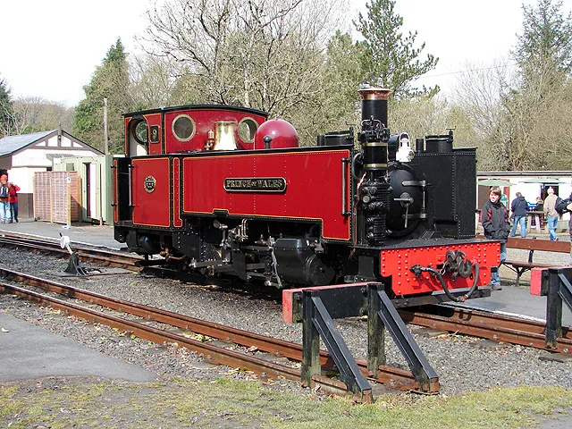
Vale of Rheidol Railway
Heritage railways · 1.4 km

Tan-y-ffordd
Vineyards · 1.4 km
Caer Rufeinig Pen-llwyn
Hill forts · 1.4 km

Aberffrwd Uchaf
Historic houses · 1.5 km

Aberffrwd railway station
Heritage railway stations · 1.5 km

Goginan
Mines & mining heritage · 1.5 km

Capel Bangor
Other places · 1.6 km
Nearby
📷 3📷 5Vineyards · Mid Wales
Pant Da Wood, North-East Hillfort
Pant Da Wood, North-East Hillfort — a UK vineyard in wales mid, producing English or Welsh wine from cool-climate grape varieties.
📷 4📷 5Vineyards · Mid Wales
Pant Da Wood, South-West Hillfort
Pant Da Wood, South-West Hillfort — a UK vineyard in wales mid, producing English or Welsh wine from cool-climate grape varieties.
📷 4📷 5Heritage railways · Mid Wales
Vale of Rheidol Railway
Vale of Rheidol Railway is a heritage railway in the United Kingdom.
Where to eat & stay near Melindwr
Places to stay
 📷 5
📷 5Caravan parks · Mid Wales
Maes Bangor Caravan Park
Maes Bangor Caravan Park — a caravan park in wales mid.
 📷 5
📷 5 📷 7
📷 7Hotels · Mid Wales
George Borrow Hotel
George Borrow Hotel — a hotel in wales mid.
 📷 7
📷 7 📷 5
📷 5Caravan parks · Mid Wales
Erwbarfe Farm Caravan Park
Erwbarfe Farm Caravan Park — a caravan park in wales mid.
 📷 5
📷 5Caravan parks · Mid Wales
Woodlands Caravan Park Devils Bridge
Woodlands Caravan Park Devils Bridge — a caravan park in wales mid.
Places to eat & drink
 📷 5
📷 5Cafés · Mid Wales
Llywernog Silver Lead Mine
Llywernog Silver Lead Mine — a café in wales mid.
 📷 5
📷 5 📷 7
📷 7 📷 4
📷 4 📷 5
📷 5Restaurants · Mid Wales
The White Lion Hotel
The White Lion Hotel — a restaurant in wales mid.
More places in this region
 📷 3
📷 3 📷 3
📷 3Stone circles · Mid Wales
Pen-y-Beacon Stone Circle
Pen-y-Beacon Stone Circle — a stone circle in wales-mid, United Kingdom.
 📷 3
📷 3Stone circles · Mid Wales
Cefn Gwernffrwd Stone Circle
Cefn Gwernffrwd Stone Circle — a stone circle in wales-mid, United Kingdom.
 📷 2
📷 2Stone circles · Mid Wales
Trefaes Ganol Standing Stone
Trefaes Ganol Standing Stone — a stone circle in wales-mid, United Kingdom.
Frequently asked questions
- Where is Melindwr?
- Melindwr is in Mid Wales, United Kingdom (postcode SY23 3NS), in the parish of Melindwr.
- What is Melindwr?
- Melindwr in Wales Mid, United Kingdom.
- How do I get to Melindwr?
- The nearest railway station is Aberffrwd, about 1.4 km away. Drivers can use postcode SY23 3NS.
- Is Melindwr free to visit?
- Yes, Melindwr is free to enter.
- How do I get to Melindwr?
- The nearest railway station is Aberffrwd, about 1.4 km away. Drivers can navigate to postcode SY23 3NS.