
Natural landmarks · Northern Ireland
Meigh
Also known as: An Mhaigh, Contae Ard Mhacha
In or near Killean.
Meigh in Northern Ireland, United Kingdom.

Eric Jones — CC BY-SA 2.0 via Wikimedia Commons licence

Plan your visit
- Typical visit
- 1 h–2 h
- Nearest railway station
- Newry · 8.1 km
- Free entry
- Dog-friendly
About
Meigh is a place of interest in Northern Ireland, United Kingdom — drawn from open-data sources for visitor reference. See the linked Wikipedia article for the full description.
Photo gallery
From the Wikipedia article
Meigh (from Irish Máigh/an Mhaigh, meaning 'the plain') is a small village and townland near Slieve Gullion in County Armagh, Northern Ireland. It had a population of 444 people in the 2001 Census. It lies within the Newry, Mourne and Down District Council area.
Excerpt from Wikipedia under CC BY-SA 4.0. See the source article linked in Sources below.
Background
History
Meigh began as a cluster of buildings around the crossroads formed by Drumintee Road, Newry Road, Chapel Road and Railway Road. Meigh, along with the rest of South Armagh, would have been transferred to the Irish Free State had the recommendations of the Irish Boundary Commission been enacted in 1925. In the 2000s, many new houses and businesses were built.
Sourced from Wikipedia under CC BY-SA 4.0.
- Coordinates
- 54.1167, -6.3833
- District
- Newry, Mourne and Down
- Postcode
- BT35 8SU
- Parliamentary constituency
- Newry and Armagh
- Nearest railway station
- Newry — 8.1 km
Sources
Other places nearby

Slieve Gullion Getaways
Caravan parks · 0.7 km

Adavoyle railway station
Natural landmarks · 1.1 km

Camlough Fault
Natural landmarks · 1.2 km

Clonlum South Cairn
Burial mounds & barrows · 1.4 km

Faughil
Mountains & hills · 1.7 km
Faughill Mountain
Mountains & hills · 1.8 km
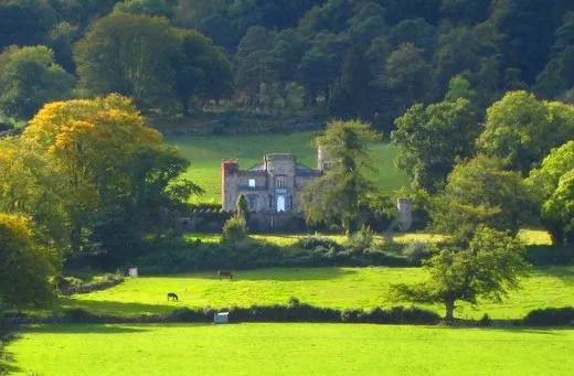
Killevy Castle
Castles · 1.9 km

Killeavy Castle
Castles · 1.9 km

Killeavy Castle
Castles · 1.9 km

Clonlum North Cairn
Burial mounds & barrows · 2.0 km

Lisbanemore Cashel
Archaeological sites · 2.1 km

Newtowncloghoge
Natural landmarks · 2.2 km
Nearby
📷 5Caravan parks · Northern Ireland
Slieve Gullion Getaways
Slieve Gullion Getaways — a caravan park in northern ireland.
📷 4Natural landmarks · Northern Ireland
Adavoyle railway station
Adavoyle railway station in Northern Ireland, United Kingdom.
📷 3Natural landmarks · Northern Ireland
Camlough Fault
Camlough Fault in Northern Ireland, United Kingdom.
📷 3Burial mounds & barrows · Northern Ireland
Clonlum South Cairn
Clonlum South Cairn — a burial mound in northern-ireland, United Kingdom.
📷 5📷 5Mountains & hills · Northern Ireland
Faughill Mountain
Faughill Mountain — mountain in northern ireland. Elevation: 244 m.
Where to eat & stay near Meigh
Places to stay
📷 5Caravan parks · Northern Ireland
Slieve Gullion Getaways
Slieve Gullion Getaways — a caravan park in northern ireland.
 📷 5
📷 5Hostels · Northern Ireland
Kilbroney Youth Centre C.O.I
Kilbroney Youth Centre C.O.I — a hostel in northern ireland.
 📷 5
📷 5Caravan parks · Northern Ireland
Kilbroney Caravan Park
Kilbroney Caravan Park — a caravan park in northern ireland.
 📷 5
📷 5Caravan parks · Northern Ireland
Touring in the Trees - Kilbroney
Touring in the Trees - Kilbroney — a caravan park in northern ireland.
 📷 5
📷 5Caravan parks · Northern Ireland
Loughside Holiday Park
Loughside Holiday Park — a caravan park in northern ireland.
 📷 5
📷 5More natural landmarks in this region
 Flagship📷 4
Natural landmarks · Northern Ireland
Lough Erne
Lough Erne — lake in County Fermanagh, Northern Ireland, UK.
 Flagship📷 4
Natural landmarks · Northern Ireland
Lough Neagh
Lough Neagh — large lake in Northern Ireland.
 📷 3
📷 3Natural landmarks · Northern Ireland
Ballysaggart Lough
Ballysaggart Lough — lake in the United Kingdom.
 📷 5
📷 5Natural landmarks · Northern Ireland
Belmore Mountain
Belmore Mountain — mountain in the United Kingdom.
Frequently asked questions
- Where is Meigh?
- Meigh is in Northern Ireland, United Kingdom (postcode BT35 8SU).
- What is Meigh?
- Meigh in Northern Ireland, United Kingdom.
- How do I get to Meigh?
- The nearest railway station is Newry, about 8.1 km away. Drivers can use postcode BT35 8SU.
- Is Meigh free to visit?
- Yes, Meigh is free to enter.
- How do I get to Meigh?
- Drivers can navigate to postcode BT35 8SU. It sits within the Newry and Armagh parliamentary constituency.