Other places · Mid Wales
Manordeifi
Also known as: Maenordeifi
In or near Aberporth.
Manordeifi in Wales Mid, United Kingdom.

Adrian Dust — CC BY-SA 2.0 via Wikimedia Commons licence
Plan your visit
- Typical visit
- 1 h–2 h
About
Manordeifi is a place of interest in Wales Mid, United Kingdom — drawn from open-data sources for visitor reference. See the linked Wikipedia article for the full description.
Photo gallery
From the Wikipedia article
Manordeifi (Welsh: Maenordeifi) is a parish and community in the hundred of Cilgerran, in the northeast corner of Pembrokeshire, Wales. The population of the community in 2001 was 478. It has an elected community council and is part of the Cilgerran electoral ward for the purposes of elections to Pembrokeshire County Council. In addition to scattered settlement, the parish contains the villages of Abercych and Newchapel (Welsh: Capelnewydd), and many listed buildings and structures.
Excerpt from Wikipedia under CC BY-SA 4.0. See the source article linked in Sources below.
Background
History
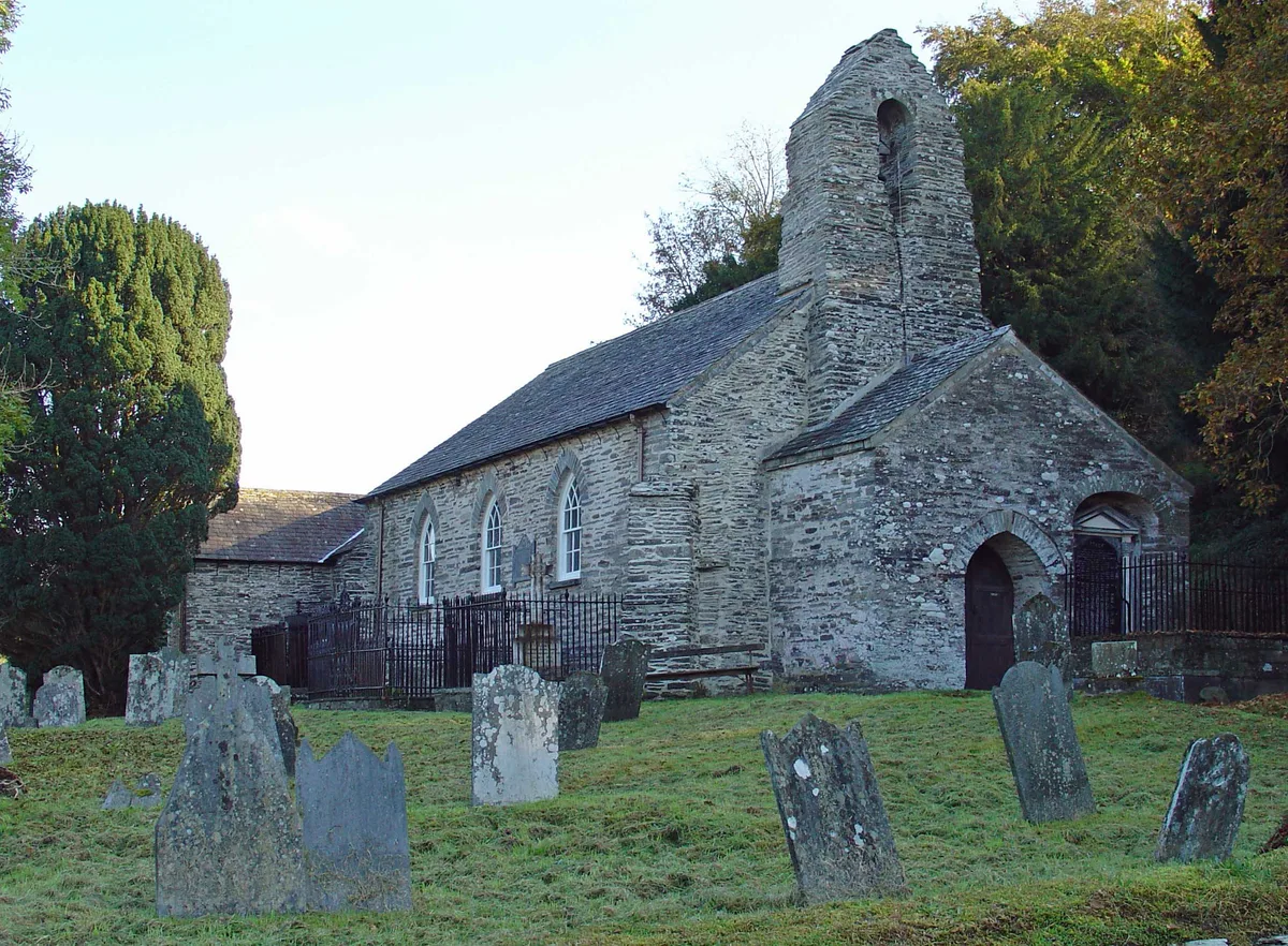
Manordeifi's old parish church, situated in the edge of the River Teifi floodplain at , was abandoned in favour of a new church built on the hill top in the nineteenth century. The old church (mainly 13th-14th century) preserves many old features. A coracle hangs in the porch, providing a means of escape during floods. Manordeifi (as Manerdve) is marked on a 1578 parish map of Pembrokeshire. The population of the parish was: 745 (1801): 956 (1851): 631 (1901): 602 (1951): 402 (1981). The percentage of Welsh speakers was: 87 (1891): 94 (1931): 74 (1971).
Sourced from Wikipedia under CC BY-SA 4.0.
- Coordinates
- 52.0500, -4.5833
- District
- Pembrokeshire
- Parish
- Manordeifi
- Postcode
- SA43 2PJ
- Parliamentary constituency
- Ceredigion Preseli
- Official site
- neighbourhood.statistics.gov.uk
Sources
- wikidata: Q6751430 (CC0)
- wikipedia: Manordeifi (CC BY-SA 4.0)
Other places nearby

Church of Saint David, Carregwen
Historic churches · 0.6 km
Manordeifi Old Church
Historic churches · 0.9 km

Manordeifi
Villages · 1.0 km

Onnen Deg Defended Settlement
Archaeological sites · 1.3 km

Onnen-Deg Defended Settlement
Vineyards · 1.3 km

Llwyndyrus Castle
Literary houses · 1.4 km

Llwynduris Castle Mound
Castles · 1.4 km

Llechryd
Natural landmarks · 1.6 km

Cemaes Rural District
Other places · 1.7 km
Pen-y-lan
Other places · 1.7 km

Castle Malgwyn Bridge
Historic bridges · 1.8 km

Llechryd Bridge
Historic bridges · 1.8 km
Nearby
📷 5Historic churches · Mid Wales
Church of Saint David, Carregwen
Church of Saint David, Carregwen — Grade II listed building-listed church in wales-mid, United Kingdom.
📷 3Historic churches · Mid Wales
Manordeifi Old Church
Manordeifi Old Church — church in Pembrokeshire, Wales, UK.
📷 5📷 3Archaeological sites · Mid Wales
Onnen Deg Defended Settlement
Onnen Deg Defended Settlement — a archaeological in wales-mid, United Kingdom.
📷 5Vineyards · Mid Wales
Onnen-Deg Defended Settlement
Onnen-Deg Defended Settlement — a UK vineyard in wales mid, producing English or Welsh wine from cool-climate grape varieties.
📷 5Literary houses · Mid Wales
Llwyndyrus Castle
Llwyndyrus Castle — a literary house museum in wales mid.
Where to eat & stay near Manordeifi
Places to stay
 📷 5
📷 5Caravan parks · Mid Wales
Aberdwylan Caravan Park
Aberdwylan Caravan Park — a caravan park in wales mid.
 📷 5
📷 5Campsites · Mid Wales
Cenarth Falls Holiday Park
Cenarth Falls Holiday Park — a campsite in wales mid.
 📷 5
📷 5Campsites · Mid Wales
Argoet Meadow Camping and Caravan Park
Argoet Meadow Camping and Caravan Park — a campsite in wales mid.
 📷 5
📷 5 📷 5
📷 5Campsites · Mid Wales
Top of the woods
Top of the woods — a campsite in wales mid.

Places to eat & drink
 📷 5
📷 5 📷 3
📷 3Historic pubs · Mid Wales
The Pendre Inn
The Pendre Inn — Historic pub — listed building or notable heritage status.
 📷 4
📷 4Historic pubs · Mid Wales
Cardiff Arms
Cardiff Arms — Historic pub — listed building or notable heritage status.
 📷 5
📷 5Historic pubs · Mid Wales
White Hart
White Hart — Historic pub — listed building or notable heritage status.
 📷 3
📷 3Historic pubs · Mid Wales
The Three Horseshoes
The Three Horseshoes — Historic pub — listed building or notable heritage status.
 📷 5
📷 5Restaurants · Mid Wales
Fusion Bar and Restaurant
Fusion Bar and Restaurant — a restaurant in wales mid.
More places in this region
 📷 5
📷 5 📷 3
📷 3Other places · Mid Wales
Sheep Music
Sheep Music is a three-day world music festival which takes place during July each year in Presteigne. It has 22 years of history, starting as a party on The Warden in 1991. Since moving to its curren
 📷 2
📷 2 📷 4
📷 4Frequently asked questions
- Where is Manordeifi?
- Manordeifi is in Mid Wales, United Kingdom (postcode SA43 2PJ), in the parish of Manordeifi.
- What is Manordeifi?
- Manordeifi in Wales Mid, United Kingdom.
- How do I get to Manordeifi?
- Drivers can use postcode SA43 2PJ.
- How do I get to Manordeifi?
- Drivers can navigate to postcode SA43 2PJ. It sits within the Ceredigion Preseli parliamentary constituency.