Towns & cities · West Midlands
Maisemore
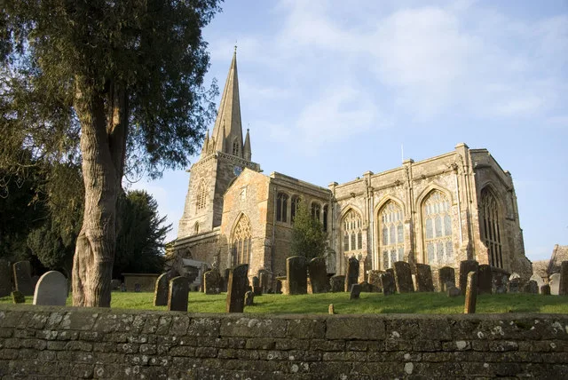
Maisemore — village and civil parish in Gloucestershire, United Kingdom.

Wikimedia Commons contributors — see linked file page for photographer and licence licence
Plan your visit
- Typical visit
- 3 h–6 h
- Nearest railway station
- Gloucester · 3.4 km
- Free entry
- Family-friendly
- Dog-friendly
About
Maisemore is a town, city, village or settlement in the United Kingdom. Recent population estimates put it at around 458 people. Address: GL2. Wikidata describes it as: "village and civil parish in Gloucestershire, United Kingdom". Coordinates: 51.8890°, -2.2710°.
Photo gallery
Protected designations
- Area of Outstanding Natural Beauty: Cotswolds
Designations sourced from Natural England open data under OGL v3.
From the Wikipedia article
Maisemore is a village and civil parish in Gloucestershire, England. It lies on the A417 road 2.5 miles (4 km) northwest of Gloucester, on the west bank of the River Severn. In the 2001 census the parish had a population of 488, reducing to 458 at the 2011 census. The parish includes the hamlet of Overton, 1 mile (1.6 km) north west of the village.
Excerpt from Wikipedia under CC BY-SA 4.0. See the source article linked in Sources below.
Background
History
The name of the village appears to be of Welsh origin, meaning "great field" (). The northern part of Alney Island, which is within the parish of Maisemore, is known as Maisemore Ham, combining Welsh and Old English words for field or meadow (ham, meaning "meadow"). The village was originally around the church. Probably in the 14th century, the present linear village was replanned further south, leaving the church separated from its settlement.
Sourced from Wikipedia under CC BY-SA 4.0.
- Coordinates
- 51.8890, -2.2710
- County
- Gloucestershire
- District
- Tewkesbury
- Parish
- Maisemore
- Postcode
- GL2
- Parliamentary constituency
- Forest of Dean
- Population
- 458
- Nearest railway station
- Gloucester — 3.4 km
Sources
- wikidata: Q256243 (CC0)
- wikipedia: Maisemore (CC BY-SA 4.0)
- commons: St Giles, Maisemore, the tower.JPG (CC BY-SA 4.0)
Other places nearby
Loading nearby places…
Nearby
 📷 3
📷 3Memorials & monuments · West Midlands
Vallender And Syms Monuments, In Churchyard, About 7M South Of East End Of Nave, Church Of St Giles
Vallender And Syms Monuments, In Churchyard, About 7M South Of East End Of Nave, Church Of St Giles — Grade II listed building-listed memorial in england-west-midlands, United Kingdom.
📷 3Memorials & monuments · West Midlands
Wadley Monument In Churchyard About 2 Metres South West Of Porch, Church Of St Giles
Wadley Monument In Churchyard About 2 Metres South West Of Porch, Church Of St Giles — Grade II listed building-listed memorial in england-west-midlands, United Kingdom.
📷 3Memorials & monuments · West Midlands
Two Monuments In Churchyard, About 1M South Of Tower, Church Of St Giles
Two Monuments In Churchyard, About 1M South Of Tower, Church Of St Giles — Grade II listed building-listed memorial in england-west-midlands, United Kingdom.
 📷 5
📷 5Museums · West Midlands
River Leadon
River Leadon — a museum in england-west-midlands, United Kingdom.
 📷 5
📷 5Mountains & hills · West Midlands
Lassington Hill
Lassington Hill — mountain in england west midlands. Elevation: 60 m.
 📷 3
📷 3Wildlife reserves · West Midlands
Lassington Wood
Lassington Wood — nature reserve in Gloucestershire, England.
Where to eat & stay near Maisemore
Places to stay
 📷 5
📷 5Campsites · West Midlands
Court Farm Camping
Court Farm Camping — a campsite in england west midlands.
 📷 5
📷 5Hotels · West Midlands
Hatherley Manor Hotel
Hatherley Manor Hotel — a hotel in england west midlands.
 📷 5
📷 5Caravan parks · West Midlands
Woodgreen Farm CL
Woodgreen Farm CL — a caravan park in england west midlands.
 📷 5
📷 5Campsites · West Midlands
The Red Lion Caravan and Camping Park
The Red Lion Caravan and Camping Park — a campsite in england west midlands.
 📷 5
📷 5Caravan parks · West Midlands
Fieldview Caravan Park
Fieldview Caravan Park — a caravan park in england west midlands.
 📷 5
📷 5Hotels · West Midlands
Bowden Hall
Bowden Hall — a hotel in england west midlands.
Places to eat & drink
 📷 5
📷 5Historic pubs · South East England
The Pelican Inn
The Pelican Inn in England South East, United Kingdom.
 📷 5
📷 5Historic pubs · South East England
Dick Whittington Tavern
Dick Whittington Tavern in England South East, United Kingdom.
 📷 5
📷 5Historic pubs · South East England
Coach And Horses Inn
Coach And Horses Inn in England South East, United Kingdom.
 📷 5
📷 5Historic pubs · South East England
Fountain Inn
Fountain Inn in England South East, United Kingdom.
 📷 5
📷 5Historic pubs · South East England
The Fleece Hotel
The Fleece Hotel in England South East, United Kingdom.
 📷 5
📷 5Historic pubs · South East England
Imperial Inn
Imperial Inn in England South East, United Kingdom.
More towns in this region
 Flagship📷 3
Towns & cities · West Midlands
Adderbury
Adderbury — village and civil parish in Cherwell district, Oxfordshire, England.
 Flagship📷 3
Towns & cities · West Midlands
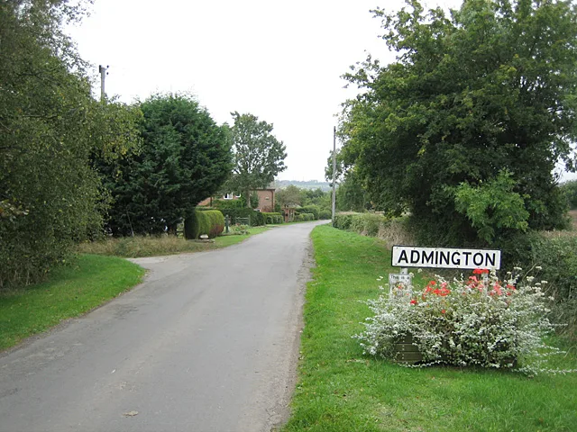
Admington
Admington — village in Warwickshire, England, UK.
 Flagship📷 3
Towns & cities · West Midlands
Aldington
Aldington — village in Worcestershire, United Kingdom.
 Flagship📷 5
Towns & cities · West Midlands
Anstey
Anstey — large village in Leicestershire, England.
Frequently asked questions
- Where is Maisemore?
- Maisemore is in Gloucestershire, the West Midlands, United Kingdom (postcode GL2), in the parish of Maisemore.
- What is Maisemore?
- Maisemore — village and civil parish in Gloucestershire, United Kingdom.
- How do I get to Maisemore?
- The nearest railway station is Gloucester, about 3.4 km away. Drivers can use postcode GL2.
- Is Maisemore a protected site?
- Yes — Maisemore is part of the Cotswolds National Landscape (AONB).
- Is Maisemore free to visit?
- Yes, Maisemore is free to enter.
- How do I get to Maisemore?
- The nearest railway station is Gloucester, about 3.4 km away. Drivers can navigate to postcode GL2.