
Towns & cities · East Midlands
Lyddington
Lyddington — village in Rutland, England, UK.

Wikimedia Commons contributors — see linked file page for photographer and licence licence

Plan your visit
- Typical visit
- 3 h–6 h
- Nearest railway station
- Corby · 8.4 km
- Free entry
- Family-friendly
- Dog-friendly
Getting there & planning your visit
Lyddington is located in the West Midlands region, with the postcode LE15. The nearest railway station is Corby, which is 8.4 km away. Entry to Lyddington is free.
About
Lyddington is a town, city, village or settlement in the United Kingdom. It covers approximately 3 km². Recent population estimates put it at around 383 people. Address: LE15. Wikidata describes it as: "village in Rutland, England, UK". Coordinates: 52.5630°, -0.7090°.
Photo gallery
From the Wikipedia article
Lyddington is a village and civil parish in the county of Rutland in the East Midlands of England. The population of the parish was 383 at the 2021 census. The village's name origin is uncertain. Perhaps, 'farm/settlement of Hlyda' or 'farm/settlement with a noisy stream'. Lyddington Bede House, owned by English Heritage, is a Grade I listed building incorporating parts of a medieval bishop's palace. In 1547 it was seized on behalf of the king from the bishops of Lincoln and later passed to Lord Burghley. In 1600 part of the palace was converted into an almshouse and it continued in this use until 1930. The remains of the fishponds of the bishop's palace are nearby. St Andrew's Church is also Grade I listed. There are two public houses, The Marquess of Exeter and The Old White Hart.
Excerpt from Wikipedia under CC BY-SA 4.0. See the source article linked in Sources below.
- Coordinates
- 52.5630, -0.7090
- District
- Rutland
- Parish
- Lyddington
- Postcode
- LE15
- Parliamentary constituency
- Rutland and Stamford
- Population
- 383
- Nearest railway station
- Corby — 8.4 km
- Official site
- www.visionofbritain.org.uk
Sources
- wikidata: Q641991 (CC0)
- wikipedia: Lyddington (CC BY-SA 4.0)
- commons: Lyddington.jpg (CC BY-SA 4.0)
Other places nearby

St Andrew's Church, Lyddington
Historic churches · 0.1 km

Lyddington Bede House
Museums · 0.1 km

Standing cross on The Green, 130m north west of The Bede House
Historic houses · 0.2 km

Lyddington Village Sign
Public art & sculpture · 0.2 km

Thorpe by Water
Historic churches · 1.7 km

Stoke Dry
Historic churches · 2.0 km

St Andrew's Church, Stoke Dry
Historic churches · 2.1 km

Stoke Dry Manor
Manor houses · 2.1 km

Eyebrook Reservoir
Reservoirs & lochs · 2.6 km

Caldecott, Rutland
Historic churches · 2.7 km

Uppingham War Memorial
Memorials & monuments · 2.8 km
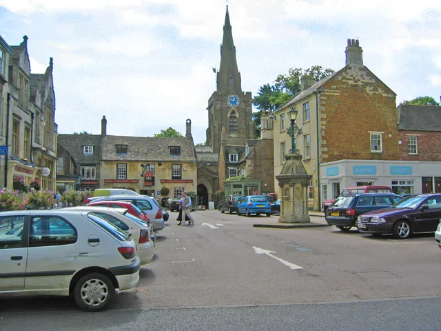
Church of St Peter and St Paul, Uppingham
Historic churches · 2.8 km
Lyddington is a charming town in the East Midlands, offering visitors a blend of historic architecture and local hospitality. You can explore the grand Church of St James the Great and the historic Lyddington Bede House. For a relaxing break, The Hatton Arms Inn provides a warm welcome in this peaceful setting.
At a glance
- Population
- 383
- Constituency
- Rutland and Stamford
- Top categories near here
Things to see in Lyddington
18 attractions within 12 km. Full guide: things to do in Lyddington →
 📷 5
📷 5Historic pubs · East Midlands
The Hatton Arms Inn
The Hatton Arms Inn in England East, United Kingdom.
 📷 3
📷 3Historic churches · East Midlands
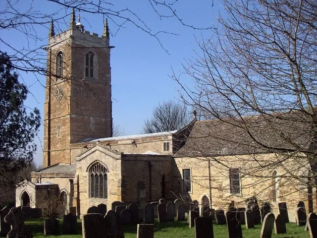
Church of St James the Great
Church of St James the Great — Grade I listed church in Gretton, Northamptonshire, England, UK.
📷 5Reservoirs & lochs · East Midlands
Eyebrook Reservoir
Eyebrook Reservoir — lake in the United Kingdom.
 📷 3
📷 3Forests & woodlands · East Midlands
Great Merrible Wood
Great Merrible Wood is a forest or woodland in the United Kingdom.
📷 5Museums · East Midlands
Lyddington Bede House
Lyddington Bede House — a Grade I-listed museum in england-west-midlands, United Kingdom.
📷 3Historic houses · East Midlands
Standing cross on The Green, 130m north west of The Bede House
Standing cross on The Green, 130m north west of The Bede House — a Grade II-listed historic house in england-west-midlands, United Kingdom.
📷 3Manor houses · East Midlands
Stoke Dry Manor
Stoke Dry Manor — Grade II listed building-listed manor in england-west-midlands, United Kingdom.
 📷 3
📷 3Memorials & monuments · East Midlands
Gretton War Memorial, Northamptonshire
Gretton War Memorial, Northamptonshire — Grade II listed building-listed memorial in england-west-midlands, United Kingdom.
📷 3Public art & sculpture · East Midlands
Lyddington Village Sign
Lyddington Village Sign — a public art in East Midlands, United Kingdom.
📷 5Memorials & monuments · East Midlands
Gretton Stocks & Whipping Post
Gretton Stocks & Whipping Post — a memorial in East Midlands, United Kingdom.
 📷 4
📷 4Museums · East Midlands
Eye Brook
The Eye Brook is a watercourse in the East Midlands of England and a tributary of the River Welland. It is around 18 miles (29 km) long.
📷 5Historic churches · East Midlands
Caldecott, Rutland
Caldecott is a village in the county of Rutland in the East Midlands of England. The civil parish population was 256 at the 2001 census increasing to 269 at the 2011 census. It is located about four
 📷 5
📷 5Historic churches · East Midlands
Church of St John the Evangelist, Caldecott
The Church of St John the Evangelist is the Church of England parish church in Caldecott, Rutland. It is a Grade II* listed building.
📷 5Historic churches · East Midlands
Stoke Dry
Stoke Dry — a church in england-west-midlands, United Kingdom.
📷 5Historic churches · East Midlands
Thorpe by Water
Thorpe by Water — a church in england-west-midlands, United Kingdom.
📷 5Historic churches · East Midlands
St Andrew's Church, Lyddington
St Andrew's Church, Lyddington — a church in england-west-midlands, United Kingdom.
📷 5Historic churches · East Midlands
St Andrew's Church, Stoke Dry
St Andrew's Church, Stoke Dry — a church in england-west-midlands, United Kingdom.
 📷 5
📷 5Nearby
📷 5Historic churches · East Midlands
St Andrew's Church, Lyddington
St Andrew's Church, Lyddington — a church in england-west-midlands, United Kingdom.
📷 5Museums · East Midlands
Lyddington Bede House
Lyddington Bede House — a Grade I-listed museum in england-west-midlands, United Kingdom.
📷 3Historic houses · East Midlands
Standing cross on The Green, 130m north west of The Bede House
Standing cross on The Green, 130m north west of The Bede House — a Grade II-listed historic house in england-west-midlands, United Kingdom.
📷 3Public art & sculpture · East Midlands
Lyddington Village Sign
Lyddington Village Sign — a public art in East Midlands, United Kingdom.
📷 5Historic churches · East Midlands
Thorpe by Water
Thorpe by Water — a church in england-west-midlands, United Kingdom.
📷 5Historic churches · East Midlands
Stoke Dry
Stoke Dry — a church in england-west-midlands, United Kingdom.
Where to eat & stay near Lyddington
Places to stay
 📷 5
📷 5 📷 5
📷 5Campsites · East Midlands
Wing Hall Camping & Caravan Site
Wing Hall Camping & Caravan Site — a campsite in england west midlands.
 📷 7
📷 7Hotels · East Midlands
Hampton by Hilton Corby/Kettering
Hampton by Hilton Corby/Kettering — a hotel in england west midlands. 4-star. Brand: Hampton.
 📷 5
📷 5Campsites · East Midlands
The Paddock
The Paddock — a campsite in england west midlands.
 📷 5
📷 5Hotels · East Midlands
The Saxon Crown
The Saxon Crown — a hotel in england west midlands.
📷 5Campsites · East Midlands
Lyndon Top
Lyndon Top — a campsite in england west midlands.
Places to eat & drink
📷 5Historic pubs · East Midlands
The Hatton Arms Inn
The Hatton Arms Inn in England East, United Kingdom.
 📷 5
📷 5Historic pubs · East Midlands
The White Swan Public House And Attached Carriage Arch
The White Swan Public House And Attached Carriage Arch in England East, United Kingdom.
 📷 5
📷 5Historic pubs · East Midlands
The Sun Public House
The Sun Public House in England East Midlands, United Kingdom.
 📷 5
📷 5Historic pubs · East Midlands
Horse and Trumpet Inn
Horse and Trumpet Inn in England East Midlands, United Kingdom.
 📷 5
📷 5Historic pubs · East Midlands
The Nevill Arms Public House
The Nevill Arms Public House in England East Midlands, United Kingdom.
 📷 5
📷 5Historic pubs · East Midlands
The Old Royal Oak Public House
The Old Royal Oak Public House in England East Midlands, United Kingdom.
More towns in this region
 📷 5
📷 5 📷 5
📷 5Towns & cities · East Midlands
Marholm
Marholm — village and civil parish in Cambridgeshire, UK.
 📷 5
📷 5Towns & cities · East Midlands
Thornhaugh
Thornhaugh — village and civil parish in Cambridgeshire, UK.
 Flagship📷 4
Towns & cities · East Midlands
Austerfield
Austerfield — village and civil parish in South Yorkshire, England, UK.
Frequently asked questions
- Where is Lyddington?
- Lyddington is in the East Midlands, United Kingdom (postcode LE15), in the parish of Lyddington.
- What is Lyddington?
- Lyddington — village in Rutland, England, UK.
- How do I get to Lyddington?
- The nearest railway station is Corby, about 8.4 km away. Drivers can use postcode LE15.
- Is Lyddington free to visit?
- Yes, Lyddington is free to enter.
- How do I get to Lyddington?
- Drivers can navigate to postcode LE15. It sits within the Rutland and Stamford parliamentary constituency.