
Historic churches · East Midlands
Caldecott, Rutland
In or near Lyddington.
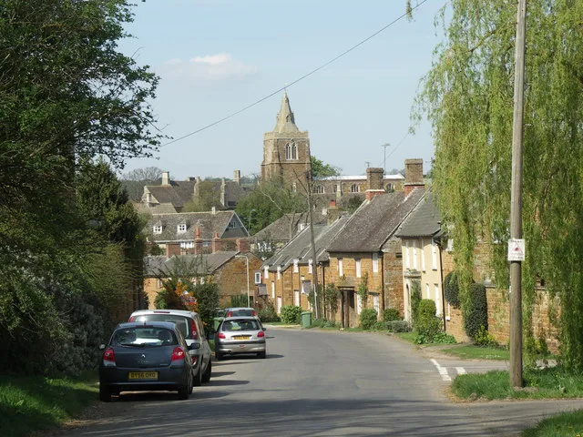
Caldecott is a village in the county of Rutland in the East Midlands of England. The civil parish population was 256 at the 2001 census increasing to 269 at the 2011 census. It is located about four

Tim Heaton — CC BY-SA 2.0 via Wikimedia Commons licence

Plan your visit
- Typical visit
- 30 min–1 h
- Nearest railway station
- Corby · 6.1 km
- Free entry
Getting there & planning your visit
To visit Caldecott in Rutland, the nearest railway station is Corby, located 6.1 km away. The postcode for sat-nav is LE16 8RY, and entry to the church is free.
About
Caldecott is a village in the county of Rutland in the East Midlands of England. The civil parish population was 256 at the 2001 census increasing to 269 at the 2011 census. It is located about four miles (6.4 km) south of Uppingham and about 4 miles north of Corby in Northamptonshire. The A6003 runs through the village; traffic flow on the bridge over the Eye Brook is controlled by traffic lights. The village's name means 'cottages which are cold'. Caldecott is the most southerly village in Rutland. It is a small historic ironstone village situated on the A6003. The village has campaigned for a bypass since at least the 1950s, which was approved in 2007 but was cancelled due to the 2008 financial crisis. Otherwise Caldecott is surrounded by rolling countryside and close to the Eyebrook Reservoir nature reserve and Rockingham Forest. Caldecott has a new playground, fundraised for and managed by the local community. The village has an active community, hosting a number of clubs & societies and events, usually at the Village Hall. The parish church of St John the Evangelist, is a Grade II* listed building; it dates back to the 12th century and is a focal point for the village, holding regular services. There is one public house - The Plough Inn - by The Green on Main Street, and an Italian restaurant - Castle Italia - on the A6003 Rockingham Road to the south of the village. There was once a railway station on the southern edge of the village. It was named after the neighbo
Photo gallery
From the Wikipedia article
Caldecott is a village in the county of Rutland in the East Midlands of England. The civil parish population was 256 at the 2001 census increasing to 269 at the 2011 census. It is located about four miles (6.4 km) south of Uppingham and about 4 miles north of Corby in Northamptonshire. The A6003 runs through the village; traffic flow on the bridge over the Eye Brook is controlled by traffic lights. The village's name means 'cottages which are cold'. Caldecott is the most southerly village in Rutland. It is a small historic ironstone village situated on the A6003. The village has campaigned for a bypass since at least the 1950s, which was approved in 2007 but was cancelled due to the 2008 financial crisis. Otherwise Caldecott is surrounded by rolling countryside and close to the Eyebrook Reservoir nature reserve and Rockingham Forest. Caldecott has a new playground, fundraised for and managed by the local community. The village has an active community, hosting a number of clubs & societies and events, usually at the Village Hall. The parish church of St John the Evangelist, is a Grade II* listed building; it dates back to the 12th century and is a focal point for the village, holding regular services. There is one public house - The Plough Inn - by The Green on Main Street, and an Italian restaurant - Castle Italia - on the A6003 Rockingham Road to the south of the village. There was once a railway station on the southern edge of the village. It was named after the neighbouring village of Rockingham, which was considered to be of more importance at the time. The railway station closed in 1966.
Excerpt from Wikipedia under CC BY-SA 4.0. See the source article linked in Sources below.
- Coordinates
- 52.5400, -0.7200
- District
- Rutland
- Parish
- Caldecott
- Postcode
- LE16 8RY
- Parliamentary constituency
- Rutland and Stamford
- Nearest railway station
- Corby — 6.1 km
- Official site
- www.visionofbritain.org.uk
Sources
- wikipedia: Caldecott, Rutland (CC BY-SA 4.0)
Other places nearby

Church of St John the Evangelist, Caldecott
Historic churches · 0.7 km

Eye Brook
Museums · 1.4 km

Eyebrook Reservoir
Reservoirs & lochs · 1.8 km

The Sun Public House
Historic pubs · 2.4 km

Great Easton War Memorial Cross
Memorials & monuments · 2.4 km
Great Easton
Villages · 2.4 km

Rockingham
Villages · 2.6 km
Lyddington
Towns & cities · 2.7 km

Stoke Dry
Historic churches · 2.7 km

St Andrew's Church, Lyddington
Historic churches · 2.7 km

Lyddington Bede House
Museums · 2.8 km

St Andrew's Church, Stoke Dry
Historic churches · 2.8 km
Nearby
📷 5Historic churches · East Midlands
Church of St John the Evangelist, Caldecott
The Church of St John the Evangelist is the Church of England parish church in Caldecott, Rutland. It is a Grade II* listed building.
📷 4Museums · East Midlands
Eye Brook
The Eye Brook is a watercourse in the East Midlands of England and a tributary of the River Welland. It is around 18 miles (29 km) long.
📷 5Reservoirs & lochs · East Midlands
Eyebrook Reservoir
Eyebrook Reservoir — lake in the United Kingdom.
📷 5Historic pubs · East Midlands
The Sun Public House
The Sun Public House in England East Midlands, United Kingdom.
📷 3Memorials & monuments · East Midlands
Great Easton War Memorial Cross
Great Easton War Memorial Cross — Grade II listed building-listed memorial in england-west-midlands, United Kingdom.
📷 5Where to eat & stay near Caldecott, Rutland
Places to stay
 📷 7
📷 7Hotels · East Midlands
Hampton by Hilton Corby/Kettering
Hampton by Hilton Corby/Kettering — a hotel in england west midlands. 4-star. Brand: Hampton.
 📷 5
📷 5 📷 5
📷 5Hotels · East Midlands
The Saxon Crown
The Saxon Crown — a hotel in england west midlands.
 📷 5
📷 5Campsites · East Midlands
Rural Relaxing
Rural Relaxing — a campsite in england west midlands.
 📷 5
📷 5Campsites · East Midlands
Wing Hall Camping & Caravan Site
Wing Hall Camping & Caravan Site — a campsite in england west midlands.
 📷 5
📷 5Campsites · East Midlands
Brightside Caravan Park
Brightside Caravan Park — a campsite in england west midlands.
Places to eat & drink
📷 5Historic pubs · East Midlands
The Sun Public House
The Sun Public House in England East Midlands, United Kingdom.
 📷 5
📷 5Historic pubs · East Midlands
The Hatton Arms Inn
The Hatton Arms Inn in England East, United Kingdom.
 📷 5
📷 5Historic pubs · East Midlands
The White Swan Public House And Attached Carriage Arch
The White Swan Public House And Attached Carriage Arch in England East, United Kingdom.
 📷 5
📷 5Historic pubs · East Midlands
Knights Lodge Public House
Knights Lodge Public House in England East Midlands, United Kingdom.
 📷 5
📷 5Historic pubs · East Midlands
Horse and Trumpet Inn
Horse and Trumpet Inn in England East Midlands, United Kingdom.
 📷 5
📷 5Historic pubs · East Midlands
The Nevill Arms Public House
The Nevill Arms Public House in England East Midlands, United Kingdom.
More places in this region
 📷 5
📷 5Historic churches · East Midlands
All Saints' Church, Stamford
All Saints' Church, Stamford — church in Stamford, Lincolnshire, England, UK.
 📷 5
📷 5Historic churches · East Midlands
Church of All Saints
Church of All Saints — church in Little Casterton, Rutland, United Kingdom.
 📷 5
📷 5Historic churches · East Midlands
Church of All Saints
Church of All Saints — church in Fenland, UK.
 📷 5
📷 5Historic churches · East Midlands
Church of St Leonard
Church of St Leonard — church in Fenland, UK.
Frequently asked questions
- Where is Caldecott, Rutland?
- Caldecott, Rutland is in the West Midlands, United Kingdom (postcode LE16 8RY), in the parish of Caldecott.
- What is Caldecott, Rutland?
- Caldecott is a village in the county of Rutland in the East Midlands of England. The civil parish population was 256 at the 2001 census increasing to 269 at the 2011 census. It is located about four
- How do I get to Caldecott, Rutland?
- The nearest railway station is Corby, about 6.1 km away. Drivers can use postcode LE16 8RY.
- Is Caldecott, Rutland free to visit?
- Yes, Caldecott, Rutland is free to enter.
- How do I get to Caldecott, Rutland?
- The nearest railway station is Corby, about 6.1 km away. Drivers can navigate to postcode LE16 8RY.