
Towns & cities · Yorkshire & the Humber
Luddington
Luddington — village in North Lincolnshire, England.

Wikimedia Commons contributors — see linked file page for photographer and licence licence

Plan your visit
- Typical visit
- 3 h–6 h
- Nearest railway station
- Althorpe · 6.1 km
- Free entry
- Family-friendly
- Dog-friendly
Getting there & planning your visit
To visit Luddington, the nearest railway station is Althorpe, located 6.1 km away. The postcode for Luddington is DN17 4RL, which can be used for sat-nav coordinates (latitude 53.6401, longitude -0.7454). Entry to the town is free.
About
Luddington is a town, city, village or settlement in the United Kingdom. Recent population estimates put it at around 419 people. Wikidata describes it as: "village in North Lincolnshire, England". Coordinates: 53.6401°, -0.7454°.
Photo gallery
See it from the streetimagery from 2020
Imagery © Mapillary contributors, CC BY-SA 4.0
Protected designations
- Site of Special Scientific Interest: Humber Estuary - 2000480 SSSI
- Ramsar wetland: Humber Estuary
Designations sourced from Natural England open data under OGL v3.
From the Wikipedia article
Luddington is a village and former civil parish, now in the parish of Luddington with Haldenby, on the Isle of Axholme in the North Lincolnshire district, in the ceremonial county of Lincolnshire, England. The population of the civil parish of "Luddington with Haldenby" at the 2011 census was 419. It is 6 miles (10 km) north-west from Scunthorpe, 6 miles south-east from Goole and 18 miles (29 km) north-east from Doncaster.
Excerpt from Wikipedia under CC BY-SA 4.0. See the source article linked in Sources below.
Background
History
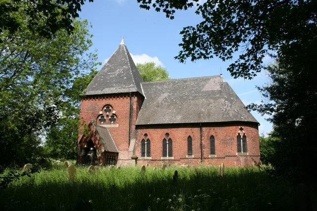
After the last Ice Age Luddington was covered by Lake Humber, until about 9,000 BC. When the melt water lake finally disappeared the Luddington area became dry, surrounded by wetlands, on a branch of the River Don. Luddington was amongst the last of a chain of islands in the marshlands of the Isle of Axholme, stretching from Epworth northwards. The site of St Oswald's pre-conquest church sits on an island separated from the rest of the village and River Don, in a circular enclosure, suggesting it might have been a ritual site well into the first millennium. At the time of the Domesday survey in 1086, Luddington was the most northerly of the parishes on the Isle of Axholme, and was a river…
Sourced from Wikipedia under CC BY-SA 4.0.
- Coordinates
- 53.6401, -0.7454
- District
- North Lincolnshire
- Parish
- Luddington and Haldenby
- Postcode
- DN17 4RL
- Parliamentary constituency
- Doncaster East and the Isle of Axholme
- Population
- 419
- Nearest railway station
- Althorpe — 6.1 km
Sources
- wikidata: Q667136 (CC0)
- wikipedia: Luddington, Lincolnshire (CC BY-SA 4.0)
- commons: Welcome To Luddington - geograph.org.uk - 58998.jpg (CC BY-SA 4.0)
Other places nearby

Waterton
Vineyards · 2.5 km

Eastoft
Historic churches · 2.6 km

Fockerby
Villages · 2.8 km

Folly Field
Campsites · 3.1 km

Amcotts
Historic churches · 4.1 km

Burton upon Stather
Towns & cities · 4.1 km

Burton Tank Ramp
Archaeological sites · 4.2 km

Flixborough
Historic churches · 4.5 km

Coleby Wood
Mountains & hills · 5.0 km

Vazon Sliding Railway Bridge
Historic bridges · 5.2 km

Keadby
Villages · 5.2 km

Gunness
Historic churches · 5.3 km
Luddington is a village located in Yorkshire with a population of 419. Our guide lists nearby attractions within reach.
At a glance
- Population
- 419
- Constituency
- Doncaster East and the Isle of Axholme
- Top categories near here
Things to see in Luddington
23 attractions within 12 km. Full guide: things to do in Luddington →
 📷 5
📷 5Historic churches · East Midlands
East Butterwick
East Butterwick — a church in england-yorkshire, United Kingdom.
 📷 5
📷 5 📷 5
📷 5Historic bridges · Yorkshire & the Humber
Keadby Bridge
Keadby Bridge is a historic bridge in the United Kingdom.
 📷 3
📷 3Historic churches · Yorkshire & the Humber
St John the Baptist's Church, Burringham
St John the Baptist's Church, Burringham — grade II listed church in Burringham, North Lincolnshire, Lincolnshire, England, UK.
📷 3Historic bridges · Yorkshire & the Humber
Vazon Sliding Railway Bridge
Vazon Sliding Railway Bridge is a historic bridge in the United Kingdom.
 📷 3
📷 3Theatres · Yorkshire & the Humber
Pavilion Picture House
Pavilion Picture House in England Yorkshire, United Kingdom.
 📷 3
📷 3Historic bridges · Yorkshire & the Humber
Bridge On Former Crowle Belton Road Over North Engine Drain
Bridge On Former Crowle Belton Road Over North Engine Drain — Grade II listed building-listed bridge in england-yorkshire, United Kingdom.
📷 3Historic bridges · Yorkshire & the Humber
Bridge On Former Crowle Belton Road Over Hatfield Waste Drain
Bridge On Former Crowle Belton Road Over Hatfield Waste Drain — Grade II listed building-listed bridge in england-yorkshire, United Kingdom.
 📷 3
📷 3Memorials & monuments · Yorkshire & the Humber
Belton War Memorial
Belton War Memorial — Grade II listed building-listed memorial in england-yorkshire, United Kingdom.
 📷 3
📷 3Memorials & monuments · Yorkshire & the Humber
Ealand War Memorial
Ealand War Memorial — a memorial in england-yorkshire, United Kingdom.
 📷 5
📷 5Natural landmarks · Yorkshire & the Humber
The Axholme Academy
The Axholme Academy — a school heritage in england-yorkshire, United Kingdom.
 📷 5
📷 5Museums · Yorkshire & the Humber
Crowle, Lincolnshire
Crowle, Lincolnshire — a museum in england-yorkshire, United Kingdom.
 📷 5
📷 5Historic churches · Yorkshire & the Humber
Althorpe
Althorpe is a small village and former civil parish, now in the parish of Keadby with Althorpe, in the North Lincolnshire district, in the ceremonial county of Lincolnshire, England. It is four miles
 📷 5
📷 5Historic churches · Yorkshire & the Humber
Ashby Parkland
Ashby Parkland is a civil parish in North Lincolnshire, England. The parish was created on 1 April 2004 and was previously part of the Burringham parish. The parish consists of a few fields and ha
📷 5Historic churches · Yorkshire & the Humber
Amcotts
Amcotts is a village and civil parish in the North Lincolnshire district of Lincolnshire, England, and on the Isle of Axholme. The village is situated north-west from Scunthorpe, and on the west bank
 📷 5
📷 5Historic churches · Yorkshire & the Humber
Burringham
Burringham — a church in england-yorkshire, United Kingdom.
📷 5Historic churches · Yorkshire & the Humber
Eastoft
Eastoft — a church in england-yorkshire, United Kingdom.
📷 5Historic churches · Yorkshire & the Humber
Gunness
Gunness — a church in england-yorkshire, United Kingdom.
 📷 5
📷 5Forts · Yorkshire & the Humber
Belwood Obelisk
Belwood Obelisk — a martello broad in england-yorkshire, United Kingdom.
 📷 5
📷 5Caravan parks · Yorkshire & the Humber
7 Lakes Country Park
7 Lakes Country Park — a caravan park in england yorkshire.
 📷 5
📷 5Vineyards · Yorkshire & the Humber
Tetley
Tetley — a UK vineyard in england yorkshire, producing English or Welsh wine from cool-climate grape varieties.
 📷 5
📷 5Farmers’ markets · Yorkshire & the Humber
Crowle Market Place
Crowle Market Place — a UK farmers' market in england yorkshire.
📷 5Nearby
📷 5Vineyards · Yorkshire & the Humber
Waterton
Waterton — a UK vineyard in england yorkshire, producing English or Welsh wine from cool-climate grape varieties.
📷 5Historic churches · Yorkshire & the Humber
Eastoft
Eastoft — a church in england-yorkshire, United Kingdom.
📷 5📷 5📷 5Historic churches · Yorkshire & the Humber
Amcotts
Amcotts is a village and civil parish in the North Lincolnshire district of Lincolnshire, England, and on the Isle of Axholme. The village is situated north-west from Scunthorpe, and on the west bank
📷 3Towns & cities · Yorkshire & the Humber
Burton upon Stather
Burton upon Stather — a village located in North Lincolnshire, United Kingdom.
Where to eat & stay near Luddington
Places to stay
📷 5 📷 5
📷 5Campsites · Yorkshire & the Humber
Normanby Park Camp Site
Normanby Park Camp Site — a campsite in england yorkshire.
 📷 5
📷 5Campsites · Yorkshire & the Humber
Whitgift Hall Caravan Site and Fishery
Whitgift Hall Caravan Site and Fishery — a campsite in england yorkshire.
 📷 5
📷 5Caravan parks · Yorkshire & the Humber
College Farm Caravan Park
College Farm Caravan Park — a caravan park in england yorkshire.
📷 5Caravan parks · Yorkshire & the Humber
7 Lakes Country Park
7 Lakes Country Park — a caravan park in england yorkshire.
 📷 4
📷 4Caravan parks · East Midlands
Epworth Fields Holiday Park
Epworth Fields Holiday Park — a caravan park in england yorkshire.
Places to eat & drink
 📷 7
📷 7Historic pubs · Yorkshire & the Humber
The Berkeley
The Berkeley in England Yorkshire, United Kingdom.
 📷 5
📷 5Historic pubs · Yorkshire & the Humber
The Cross Keys
The Cross Keys in England Yorkshire, United Kingdom.
 📷 7
📷 7Restaurants · Yorkshire & the Humber
The Lowther Hotel
The Lowther Hotel — a restaurant in england yorkshire.
 📷 4
📷 4Historic pubs · Yorkshire & the Humber
The Royal
The Royal — Historic pub — listed building or notable heritage status.
 📷 5
📷 5Historic pubs · Yorkshire & the Humber
The Buccaneer Public House
The Buccaneer Public House in England Yorkshire, United Kingdom.
 📷 7
📷 7Historic pubs · Yorkshire & the Humber
Fox And Coney Public House
Fox And Coney Public House in England Yorkshire, United Kingdom.
More towns in this region
 Flagship📷 3
Towns & cities · Yorkshire & the Humber
Hazel Grove
Hazel Grove — suburb within the Metropolitan Borough of Stockport, in Greater Manchester, England.
 Flagship📷 3
Towns & cities · Yorkshire & the Humber
High Lane
High Lane — village in the Metropolitan Borough of Stockport, Greater Manchester, United Kingdom.
 📷 5
📷 5Towns & cities · Yorkshire & the Humber
Disley
Disley — village in Cheshire East, Cheshire, England, UK.
 📷 3
📷 3Frequently asked questions
- Where is Luddington?
- Luddington is in Yorkshire, United Kingdom (postcode DN17 4RL), in the parish of Luddington and Haldenby.
- What is Luddington?
- Luddington — village in North Lincolnshire, England.
- How do I get to Luddington?
- The nearest railway station is Althorpe, about 6.1 km away. Drivers can use postcode DN17 4RL.
- Is Luddington a protected site?
- Yes — Luddington is part of the Humber Estuary - 2000480 SSSI Site of Special Scientific Interest and the Humber Estuary Ramsar wetland.
- Is Luddington free to visit?
- Yes, Luddington is free to enter.
- How do I get to Luddington?
- The nearest railway station is Althorpe, about 6.1 km away. Drivers can navigate to postcode DN17 4RL.