Archaeological sites · Scottish Highlands
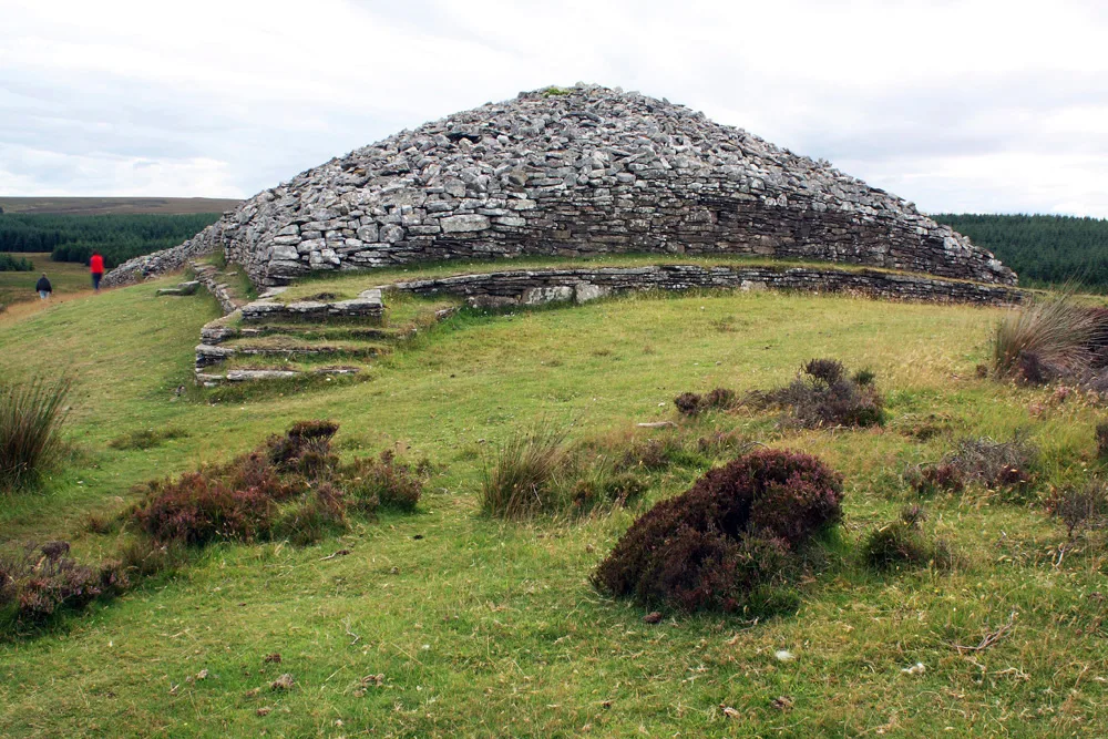
Lower Camster, broch site
Lower Camster, broch site — archaeological in scotland highlands.

Peter Wood — CC BY-SA 2.0 via Wikimedia Commons licence
Plan your visit
- Typical visit
- 45 min–1.5 h
About
Lower Camster, broch site is a archaeological located in scotland highlands. A British archaeological site recorded in OpenStreetMap with at least one heritage quality signal (Wikidata link, Wikipedia article or designated operator).
Photo gallery
Place summary
Lower Camster is an archaeological site located in the Scottish Highlands. It features a broch, a type of ancient drystone structure unique to Scotland, indicative of Iron Age habitation. The site provides insights into early Scottish architecture and community life. Visitors can explore the remains and the surrounding landscape, which offers a glimpse into the region's historical significance.
AI-generated from the structured facts on this page (operator, designation, listing, era). Not a substitute for visiting.
- Coordinates
- 58.3925, -3.2751
Sources
- osm: n12840833784 (ODbL)
- wikidata: Q56668633 (CC0)
Other places nearby
Loading nearby places…
Nearby
 📷 3
📷 3Archaeological sites · Scottish Highlands
Lower Camster, broch site
Lower Camster, broch site — a archaeological in scotland-highlands, United Kingdom.
 📷 3
📷 3Archaeological sites · Scottish Highlands
Camster Broch
Camster Broch — a archaeological in scotland-highlands, United Kingdom.
 📷 5
📷 5Archaeological sites · Scottish Highlands
Camster Broch
Camster Broch — archaeological in scotland highlands.
 📷 3
📷 3Burial mounds & barrows · Scottish Highlands
Camster Long Cairn
Camster Long Cairn — a burial mound in scotland-highlands, United Kingdom.
 📷 5
📷 5Hill forts · Scottish Highlands
Grey Cairns of Camster
Grey Cairns of Camster — chambered cairns in Scotland.
 📷 3
📷 3Burial mounds & barrows · Scottish Highlands
Camster Round Cairn
Camster Round Cairn — a burial mound in scotland-highlands, United Kingdom.
Where to eat & stay near Lower Camster, broch site
Places to stay
 📷 4
📷 4Campsites · Scottish Highlands
Caithness Camping Pods
Caithness Camping Pods — a campsite in scotland highlands.
 📷 5
📷 5Campsites · Scottish Highlands
Wick Caravan & Camping Site
Wick Caravan & Camping Site — a campsite in scotland highlands.
 📷 5
📷 5Hotels · Scottish Highlands
Ackergil Tower
Ackergil Tower — a hotel in scotland highlands.
 📷 5
📷 5Campsites · Scottish Highlands
Wildcamp latheronwheel
Wildcamp latheronwheel — a campsite in scotland highlands.
 📷 5
📷 5Campsites · Scottish Highlands
Informal campsite
Informal campsite — a campsite in scotland highlands.
 📷 5
📷 5Campsites · Scottish Highlands
Inver Caravan Park & BB
Inver Caravan Park & BB — a campsite in scotland highlands.

More archaeological sites in this region
 📷 5
📷 5Archaeological sites · Scottish Highlands
Ariundle Oakwood National Nature Reserve
Ariundle Oakwood National Nature Reserve — forested nature reserve in Highland, Scotland, UK.
 📷 3
📷 3Archaeological sites · Scottish Highlands
Abernethy Forest
Abernethy Forest — forest in Highland, Scotland, UK.
 📷 3
📷 3Archaeological sites · Scottish Highlands
Abriachan Forest
Abriachan Forest — Forest near Abriachan village in Scotland.
 📷 3
📷 3Archaeological sites · Scottish Highlands
Achnashellach Forest
Achnashellach Forest is a archaeological site in the United Kingdom.
Frequently asked questions
- Where is Lower Camster, broch site?
- Lower Camster, broch site is in the Scottish Highlands, United Kingdom.
- What is Lower Camster, broch site?
- Lower Camster, broch site — archaeological in scotland highlands.
- How do I get to Lower Camster, broch site?
- Its coordinates are 58.3925°, -3.2751°.