
Mountains & hills · North West England
Lord's Seat
In or near Cartmel Fell.
Lord's Seat — Named summit at 215.2 m.

Wikimedia Commons contributors — see linked file page for photographer and licence licence

Plan your visit
- Typical visit
- 3 h–8 h
- Best time of year
- Late spring – early autumn (May–Oct)
- Nearest railway station
- Lakeside · 6.3 km
- Free entry
- Dog-friendly
Getting there & planning your visit
To visit Lord's Seat, the nearest railway station is Lakeside, which is 6.3 km away. The postcode for navigation is LA11 6SD. Entry to the site is free.
About
Lord's Seat is a named summit in the United Kingdom. Wikidata describes it as: "Named summit at 215.2 m.". Coordinates: 54.2761°, -2.8587°.
Photo gallery
Protected designations
- Site of Special Scientific Interest: River Kent and Tributaries SSSI
- Site of Special Scientific Interest: Whitbarrow SSSI
- National Nature Reserve: WHITBARROW
Designations sourced from Natural England open data under OGL v3.
From the Wikipedia article
Whitbarrow is a hill in Cumbria, England, designated a biological Site of Special Scientific Interest and national nature reserve, forming part of the Morecambe Bay Pavements Special Area of Conservation due to its supporting some of the best European examples of natural limestone habitats. Also known as Whitbarrow Scar (though properly that term applies to the cliffs lining its western edge), the hill lies about 9 kilometres (5.6 mi) southwest of Kendal, just north of the A590 road, close to the village of Witherslack. Part of the site is a local nature reserve called Whitbarrow Scar. Whitbarrow's summit, known as Lord's Seat, is at 215 metres (705 ft) and has a prominence of 182 metres (597 ft), classifying it as a Marilyn. It is a mixture of woodland, grassland and limestone pavement. The hill is prominent from the A590 road with its steep limestone cliffs, laid down in the Carboniferous period some 350 million years ago. The main cliff faces are made up of rocks known as Dalton Beds, above which are Urswick Limestones, of which the limestone pavement (here and elsewhere around Morecambe Bay, including Hutton Roof Crags) has been formed. Whitbarrow, like most of the Lake District, shows many signs of the last ice age, including glacial erratics (boulders left behind when the ice retreated), and the limestone pavement itself, formed when ice left bare limestone exposed to the elements which eroded it and left us with the grikes and clints we see today. The limestone has been used for many purposes including building, agricultural fertiliser, and production of millstones, but is now protected by law and it is an offence to remove any. Whitbarrow NNR is owned and managed by the Forestry Commission, Lake District National Park Authority and the Cumbria Wildlife Trust. Much of Whitbarrow is covered in woodland, initially naturally and from 1919 following planting; the Forestry Commission now holds leases on parts of the hill. A variety of techniques are used to…
Excerpt from Wikipedia under CC BY-SA 4.0. See the source article linked in Sources below.
- Coordinates
- 54.2761, -2.8587
- District
- Westmorland and Furness
- Parish
- Witherslack, Meathop and Ulpha
- Postcode
- LA11 6SD
- Parliamentary constituency
- Westmorland and Lonsdale
- Nearest railway station
- Lakeside — 6.3 km
Sources
- osm: n434309611 (ODbL)
- wikipedia: Whitbarrow (CC BY-SA 4.0)
- commons: Whitbarrow from near Witherslack School.jpg (CC BY-SA 4.0)
Featured in this guide
Other places nearby

Whitbarrow - Lord's Seat
Mountains & hills · 0.0 km

Whitbarrow
Mountains & hills · 1.5 km

Lime Kiln Row
Historic houses · 1.9 km

Cowmire Hall and wall running approximately 20 metres to east, with gate piers
Historic houses · 2.2 km

Yewbarrow
Mountains & hills · 2.3 km

Witherslack Cycle Barn Bunk House
Hostels · 2.5 km

Cartmel Fell
Towns & cities · 2.5 km

Hodge Hill Hall
Historic houses · 2.6 km

Moss Howe Farm campsite
Campsites · 2.6 km

Cartmel Fell War Memorial
Memorials & monuments · 2.7 km
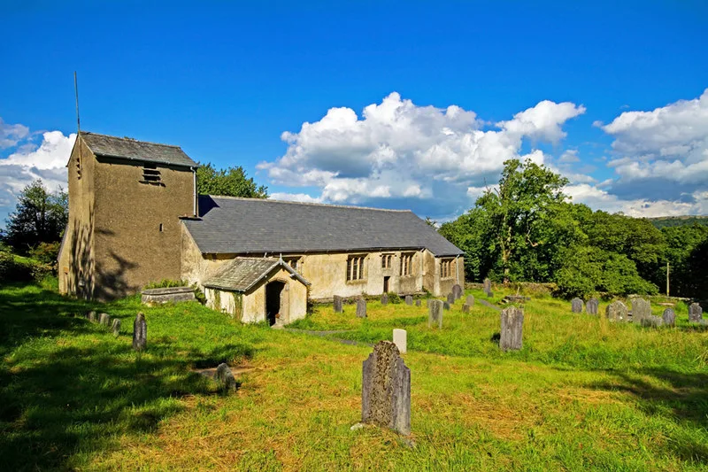
St Anthony's Church, Cartmel Fell
Historic churches · 2.7 km

Bridge Approximately 30 Metres To East Of Lyth Valley Hotel
Historic bridges · 2.8 km
Nearby
📷 5Mountains & hills · North West England
Whitbarrow - Lord's Seat
Whitbarrow - Lord's Seat — a hill or mountain in england north west.
📷 5📷 3Historic houses · North West England
Lime Kiln Row
Lime Kiln Row — a historic house in england-north-west, United Kingdom.
📷 3Historic houses · North West England
Cowmire Hall and wall running approximately 20 metres to east, with gate piers
Cowmire Hall and wall running approximately 20 metres to east, with gate piers — Grade II* listed house in the parish of Crosthwaite and Lyth, Cumbria, England, UK.
📷 5Mountains & hills · North West England
Yewbarrow
Yewbarrow — a hill or mountain in england north west.
📷 5Hostels · North West England
Witherslack Cycle Barn Bunk House
Witherslack Cycle Barn Bunk House — a hostel in england north west.
Where to eat & stay near Lord's Seat
Places to stay
📷 5Hostels · North West England
Witherslack Cycle Barn Bunk House
Witherslack Cycle Barn Bunk House — a hostel in england north west.
📷 3Campsites · North West England
Moss Howe Farm campsite
Moss Howe Farm campsite — a campsite in england north west.
 📷 5
📷 5Caravan parks · North West England
Gilpin Bridge Caravan Park
Gilpin Bridge Caravan Park — a caravan park in england north west.
 📷 4
📷 4Campsites · North West England
Borderside Farm
Borderside Farm — a campsite in england north west.
 📷 5
📷 5Caravan parks · North West England
Lambhowe Caravan Park
Lambhowe Caravan Park — a caravan park in england north west.
 📷 5
📷 5Caravan parks · North West England
College Green Caravan Site
College Green Caravan Site — a caravan park in england north west.
Places to eat & drink
 📷 7
📷 7 📷 7
📷 7Cafés · North West England
Joey's Cafe
Joey's Cafe — a café in england north west.
 📷 5
📷 5Restaurants · North West England
L'Enclume
L'Enclume — a restaurant in england north west.
 📷 4
📷 4Restaurants · North West England
L'Enclume
L'Enclume (pronounced [lɑ̃.klym], French for "the anvil") is a Modern British restaurant opened in 2002 in Cartmel, Cumbria, England, run by the chef Simon Rogan and his partner, Penny Tapsell. L'Encl
 📷 7
📷 7Historic pubs · North West England
Hole in t'Wall public house, With Attached Buildings To South
Hole in t'Wall public house, With Attached Buildings To South in England North West, United Kingdom.
 📷 5
📷 5Historic pubs · North West England
Sun Cottage Sun Inn Public House
Sun Cottage Sun Inn Public House in England North West, United Kingdom.
More mountains in this region
 📷 5
📷 5Mountains & hills · North West England
Appleton Park
Appleton Park — a hill or mountain in england west midlands.
 📷 5
📷 5Mountains & hills · North West England
High Warren
High Warren — mountain in england west midlands. Elevation: 105 m.
 📷 5
📷 5Mountains & hills · North West England
Alderley Edge
Alderley Edge — mountain in england west midlands. Elevation: 194 m.
 📷 3
📷 3Frequently asked questions
- Where is Lord's Seat?
- Lord's Seat is in North-West England, United Kingdom (postcode LA11 6SD), in the parish of Witherslack, Meathop and Ulpha.
- What is Lord's Seat?
- Lord's Seat — Named summit at 215.2 m.
- How do I get to Lord's Seat?
- The nearest railway station is Lakeside, about 6.3 km away. Drivers can use postcode LA11 6SD.
- Is Lord's Seat a protected site?
- Yes — Lord's Seat is part of the River Kent and Tributaries SSSI Site of Special Scientific Interest and the Whitbarrow SSSI Site of Special Scientific Interest.
- Is Lord's Seat free to visit?
- Yes, Lord's Seat is free to enter.
- How do I get to Lord's Seat?
- The nearest railway station is Lakeside, about 6.3 km away. Drivers can navigate to postcode LA11 6SD.