
Historic bridges · Central Scotland
Longformacus Bridge
In or near Duns.
Longformacus Bridge — category C listed building-listed bridge in scotland-central, United Kingdom.

M J Richardson — CC BY-SA 2.0 via Wikimedia Commons licence

Plan your visit
- Typical visit
- 15 min–30 min
- Free entry
- Dog-friendly
About
Longformacus Bridge is a category C listed building-listed bridge in scotland-central, United Kingdom, registered on the Historic Environment Scotland register (entry LB10778). Listed status protects buildings and structures of special architectural or historic interest. See the linked Wikipedia article for further details.
Photo gallery
See it from the streetimagery from 2019
Imagery © Mapillary contributors, CC BY-SA 4.0
Heritage listing
Category C Date Added 19/08/1998 Local Authority Scottish Borders Planning Authority Scottish Borders Parish Longformacus NGR NT 69297 57253 Coordinates 369297, 657253 — Earlier 19th century with later repairs. Single-arched, slightly humped bridge spanning Dye Water. Rubble-coped, recently re pointed rubble walls (rebuilt in part); rubble voussoirs to segmental arches. Much-weathered square sandstone plaque (dated 1820?) with coat of arms centred in outer face of E wall; much-eroded rectangular panel dated 1851 set to N of inner face with decorative motif at centre, much-weathered carved figureheads to outer left and right. Irregularly splayed parapet walls at either end. — An impressive stone bridge at the centre of Longformacus village, forming the main link between N and S. The plaque on the outer face is said to be dated 1820. Old postcards show a well with a tiered cap, segmental-arched niche and scrolled angle buttresses set to the N of the inner face of the E wall. Also shown is a drinking trough inset in the wall to its left. Although neither the well or trough remain (it is said they were destroyed during World War II), the well's decorative panel, dated 1851 and flanked by carved figureheads, has since been set into the E wall of the bridge.
From Historic Environment Scotland under OGL v3.
Place summary
Longformacus Bridge is a bridge located in central Scotland. It is designated as a category C listed building, recognising its historical and architectural significance.
AI-generated from the structured facts on this page (operator, designation, listing, era). Not a substitute for visiting.
- Coordinates
- 55.8076, -2.4914
- District
- Scottish Borders
- Postcode
- TD11 3PE
- Parliamentary constituency
- Berwickshire, Roxburgh and Selkirk
Sources
- wikidata: Q56618218 (CC0)
Other places nearby
Longformacus
Other places · 0.1 km

Venue Longformacus
Theatres · 0.1 km

Longformacus Parish Church
Historic churches · 0.1 km
.jpg?width=1200)
Longformacus House
Historic houses · 0.3 km

Watch Water
Other places · 0.7 km

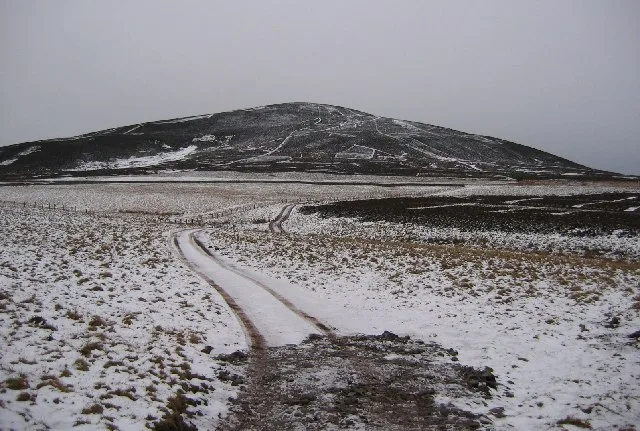
Wrunk Law
Mountains & hills · 2.3 km
Dirrington Great Law
Natural landmarks · 2.4 km

Wrunklaw
Vineyards · 2.4 km

Alisdair Thomson Memorial
Memorials & monuments · 2.8 km

Dye Water
Other places · 3.1 km

Scar Law
Mountains & hills · 4.0 km

Smiddyhill Bridge
Historic bridges · 4.0 km
Nearby
📷 5📷 3Theatres · Central Scotland
Venue Longformacus
Venue Longformacus is a theatre in the United Kingdom.
📷 5Historic churches · Central Scotland
Longformacus Parish Church
Longformacus Parish Church — category B listed building-listed church in scotland-central, United Kingdom.
📷 3Historic houses · Central Scotland
Longformacus House
Longformacus House — house in Scottish Borders, Scotland, UK.
📷 4📷 5Mountains & hills · Central Scotland
Wrunk Law
Wrunk Law — mountain in scotland central. Elevation: 364 m.
Where to eat & stay near Longformacus Bridge
Places to stay
 📷 5
📷 5Caravan parks · Scottish Lowlands
Blackadder Caravan Park
Blackadder Caravan Park — a caravan park in scotland central.
 📷 5
📷 5Caravan parks · Central Scotland
Chesterfield Caravan Park
Chesterfield Caravan Park — a caravan park in scotland central.
 📷 5
📷 5Campsites · Central Scotland
Blinkbonny Wood Campsite
Blinkbonny Wood Campsite — a campsite in scotland central.
 📷 5
📷 5Caravan parks · Central Scotland
Pease Bay Leisure Park
Pease Bay Leisure Park — a caravan park in scotland central.
 📷 5
📷 5Caravan parks · Central Scotland
Thurston Manor Caravan Park
Thurston Manor Caravan Park — a caravan park in scotland central.
 📷 5
📷 5Caravan parks · Central Scotland
Highview Caravan Park
Highview Caravan Park — a caravan park in scotland central.
Places to eat & drink
 📷 7
📷 7Historic pubs · Central Scotland
The Royal Bar, 15 Market Square, Duns
The Royal Bar, 15 Market Square, Duns in Scotland Central, United Kingdom.
 📷 5
📷 5Historic pubs · Central Scotland
The Crown & Kitchen
The Crown & Kitchen in Scotland Central, United Kingdom.
 📷 5
📷 5Historic pubs · Scottish Lowlands
The Masons Arms
The Masons Arms in Scotland Lowlands, United Kingdom.
 📷 7
📷 7Historic pubs · Scottish Lowlands
The Victoria Hotel
The Victoria Hotel in Scotland Lowlands, United Kingdom.
 📷 4
📷 4Historic pubs · Scottish Lowlands
Newcastle Arms
Newcastle Arms — Historic pub — listed building or notable heritage status.
 📷 5
📷 5Historic pubs · Central Scotland
Gardner's Arms Public House, Market Street, Haddington
Gardner's Arms Public House, Market Street, Haddington in Scotland Central, United Kingdom.
More bridges in this region
 📷 3
📷 3Historic bridges · Central Scotland
Kelloe House
Kelloe House in England North East, United Kingdom.
 📷 4
📷 4Historic bridges · Central Scotland
Chirnsidebridge
Chirnsidebridge in England North East, United Kingdom.
 📷 3
📷 3.jpg?width=1200) 📷 3
📷 3Historic bridges · Central Scotland
Achnamara Clapper Bridge
Achnamara Clapper Bridge is a historic bridge in the United Kingdom.
Frequently asked questions
- Where is Longformacus Bridge?
- Longformacus Bridge is in central Scotland, United Kingdom (postcode TD11 3PE).
- What is Longformacus Bridge?
- Longformacus Bridge — category C listed building-listed bridge in scotland-central, United Kingdom.
- How do I get to Longformacus Bridge?
- Drivers can use postcode TD11 3PE.
- Is Longformacus Bridge a listed building?
- Longformacus Bridge is officially recognised as category C listed building listed.
- Is Longformacus Bridge free to visit?
- Yes, Longformacus Bridge is free to enter.
- How do I get to Longformacus Bridge?
- Drivers can navigate to postcode TD11 3PE. It sits within the Berwickshire, Roxburgh and Selkirk parliamentary constituency.