Reservoirs & lochs · Scottish Highlands
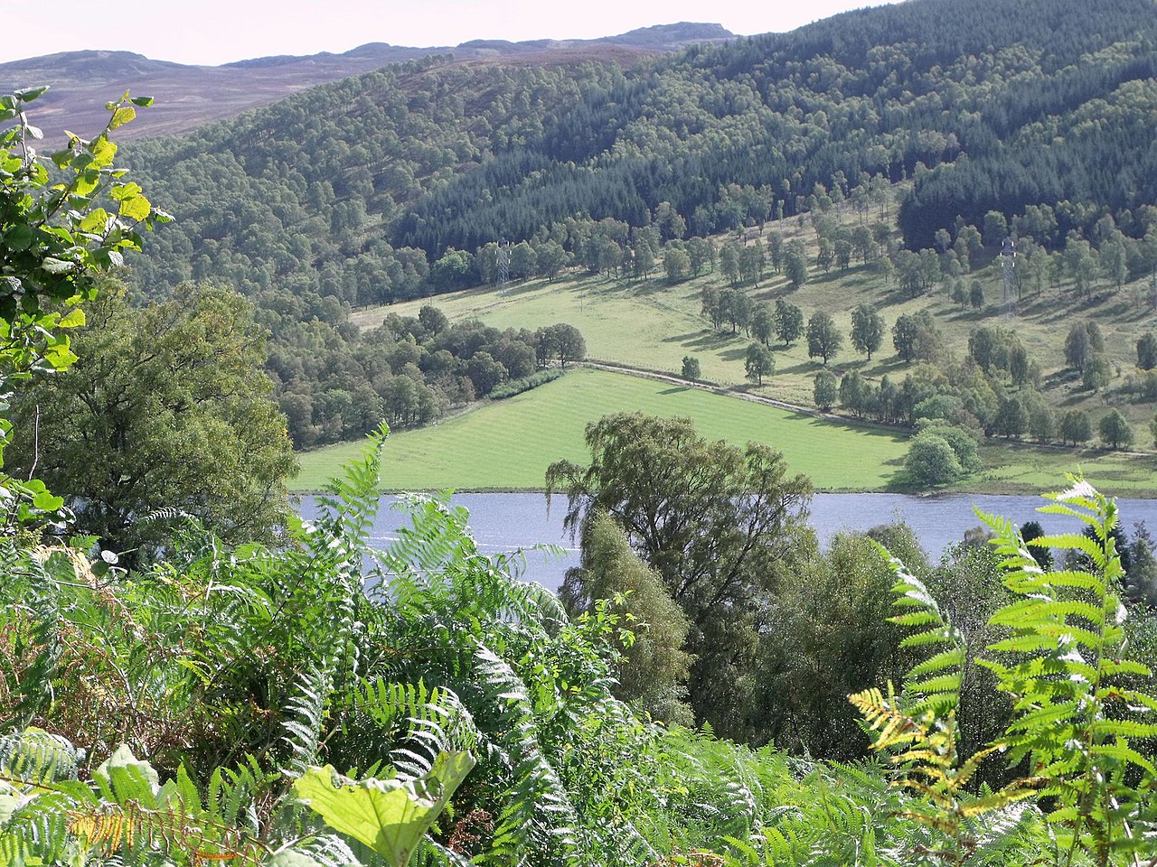
Loch Tummel
In or near Weem.
Loch Tummel — lake in Perth and Kinross, Scotland, UK, on the River Tummel.

Wikimedia Commons contributors — see linked file page for photographer and licence licence
Plan your visit
- Typical visit
- 1 h–2.5 h
- Nearest railway station
- Blair Atholl · 7.7 km
- Free entry
- Dog-friendly
Getting there & planning your visit
To visit Loch Tummel in the Scottish Highlands, the nearest railway station is Blair Atholl, located 7.7 km away. The postcode for sat-nav is PH16 5RX, and entry to the reservoir is free.
About
Loch Tummel is a reservoir in the United Kingdom. Part of Tummel hydro-electric power scheme. Wikidata describes it as: "lake in Perth and Kinross, Scotland, UK, on the River Tummel". Coordinates: 56.7111°, -3.9278°.
Photo gallery
From the Wikipedia article
Loch Tummel (Scottish Gaelic: Loch Teimheil) is a long, narrow loch, seven kilometres (4+1⁄2 miles) northwest of Pitlochry in the council area of Perth and Kinross, Scotland. It is fed and drained by the River Tummel, which flows into the River Tay about 13 km (8 mi) south-east of the Clunie Dam at the loch's eastern end. The loch is traversed by roads to both north and south. Along the northern side the road is numbered as the B8019, and runs from the Pass of Killiecrankie on the A9 in the east to Tummel Bridge at the head of the loch. The road on the southern side is unclassified, and meets the A9 further south, near to Pitlochry. The loch gives its name to the Loch Tummel National Scenic Area (NSA), one of 40 such areas in Scotland, which are defined so as to identify areas of exceptional scenery and to ensure its protection by restricting certain forms of development. The Loch Tummel Lyon NSA covers 9,013 hectares (22,272 acres), all of which lies within Perth and Kinross. The NSA covers the hills surrounding the loch, and extends along the River Tummel to also take in the area surrounding the Pass of Killiecrankie on the River Garry.
Excerpt from Wikipedia under CC BY-SA 4.0. See the source article linked in Sources below.
Background
History
The northern side of the loch has many archeological sites, including an Iron Age ring fort, abandoned townships, and the remains of Pictish fortified villages. Fincastle House, a 17th-century Category A listed building, sits at the eastern end of the strath. The raising of the loch for hydroelectricity led to the drowning of an artificial island of a type known as a crannog lying off Port an Eilean on the northern side of the loch. The island is now 3 m underwater, and was investigated by the Scottish Trust for Underwater Archaeology and Perth & Kinross Heritage Trust in 2004. A well-made flagstone floor and a flight of steps that led down a distance of 2 m to the loch bed were found.…
Sourced from Wikipedia under CC BY-SA 4.0.
- Coordinates
- 56.7111, -3.9278
- District
- Perth and Kinross
- Postcode
- PH16 5RX
- Parliamentary constituency
- Angus and Perthshire Glens
- Nearest railway station
- Blair Atholl — 7.7 km
Sources
- wikidata: Q1867303 (CC0)
- wikipedia: Loch Tummel (CC BY-SA 4.0)
- commons: Schotland Queen's View 8-05-2010 10-39-44.JPG (CC BY-SA 4.0)
Other places nearby

Tummel hydro-electric power scheme
Reservoirs & lochs · 0.8 km

dun 270m NW of Balnabodach
Vineyards · 1.4 km

An Tulach
Mountains & hills · 1.4 km

Loch Tummel
Lakes · 1.4 km

Ceann na Coille, dun
Archaeological sites · 1.6 km

Conbhar
Mountains & hills · 2.0 km

Cragan Dubh
Mountains & hills · 2.2 km

Loch Bhac
Lakes · 2.6 km

Sron Mhòr
Mountains & hills · 2.7 km

Loch Bhac
Forests & woodlands · 2.9 km

Na Clachan Aoraidh Stone Circle
Stone circles · 3.2 km

Creag an Lochain
Mountains & hills · 3.2 km
Nearby
📷 5Reservoirs & lochs · Scottish Highlands
Tummel hydro-electric power scheme
Tummel hydro-electric power scheme in Scotland Islands, United Kingdom.
📷 5Vineyards · Scottish Highlands
dun 270m NW of Balnabodach
dun 270m NW of Balnabodach — a UK vineyard in scotland highlands, producing English or Welsh wine from cool-climate grape varieties.
📷 5Mountains & hills · Scottish Highlands
An Tulach
An Tulach — mountain in scotland highlands. Elevation: 303 m.
📷 5📷 3Archaeological sites · Scottish Highlands
Ceann na Coille, dun
Ceann na Coille, dun — a archaeological in scotland-highlands, United Kingdom.
📷 5Mountains & hills · Scottish Highlands
Conbhar
Conbhar — mountain in scotland highlands. Elevation: 408 m.
Where to eat & stay near Loch Tummel
Places to stay
 📷 5
📷 5Campsites · Scottish Highlands
Ardgualich Farm & Loch Tummel Camp Site
Ardgualich Farm & Loch Tummel Camp Site — a campsite in scotland highlands.
 📷 5
📷 5Caravan parks · Scottish Highlands
Tummel Valley Holiday Park
Tummel Valley Holiday Park — a caravan park in scotland highlands. Brand: Parkdean Resorts.
 📷 5
📷 5Caravan parks · Scottish Highlands
River Tilt Park
River Tilt Park — a caravan park in scotland highlands.
 📷 5
📷 5Campsites · Scottish Highlands
Blair Castle Caravan Park
Blair Castle Caravan Park — a campsite in scotland highlands.
 📷 5
📷 5Campsites · Scottish Highlands
Glengoulandie Camping & Caravanning
Glengoulandie Camping & Caravanning — a campsite in scotland highlands.
 📷 5
📷 5Caravan parks · Scottish Highlands
Faskally Caravan Park
Faskally Caravan Park — a caravan park in scotland highlands.
Places to eat & drink
 📷 5
📷 5 📷 5
📷 5Historic pubs · Scottish Highlands
Dundarach Hotel, Perth Road
Dundarach Hotel, Perth Road in Scotland Highlands, United Kingdom.
 📷 5
📷 5Historic pubs · Scottish Highlands
Balnaguard Inn
Balnaguard Inn in Scotland Highlands, United Kingdom.
More places in this region
 Flagship📷 3
Reservoirs & lochs · Scottish Highlands
Loch Ericht
Loch Ericht — lake in Perth and Kinross, and Highland, Scotland, UK, outflows to River Ericht.
 Flagship📷 3
Reservoirs & lochs · Scottish Highlands
Loch Shin
Loch Shin — reservoir in Highland, Scotland, UK, outflows to the River Shin.
 📷 4
📷 4Reservoirs & lochs · Scottish Highlands
Backwater Reservoir
Backwater Reservoir — lake in Angus, Scotland, UK.
 📷 3
📷 3Reservoirs & lochs · Scottish Highlands
Blackwater Reservoir
Blackwater Reservoir — reservoir in Highland, Scotland, UK, outflows to the River Leven.
Frequently asked questions
- Where is Loch Tummel?
- Loch Tummel is in the Scottish Highlands, United Kingdom (postcode PH16 5RX).
- What is Loch Tummel?
- Loch Tummel — lake in Perth and Kinross, Scotland, UK, on the River Tummel.
- How do I get to Loch Tummel?
- The nearest railway station is Blair Atholl, about 7.7 km away. Drivers can use postcode PH16 5RX.
- Is Loch Tummel free to visit?
- Yes, Loch Tummel is free to enter.
- How do I get to Loch Tummel?
- The nearest railway station is Blair Atholl, about 7.7 km away. Drivers can navigate to postcode PH16 5RX.