
Forests & woodlands · South East England
Littlecote Roman Villa
In or near Chilton Foliat.
Littlecote Roman Villa is a forest or woodland in the United Kingdom.

Wikimedia Commons contributors — see linked file page for photographer and licence licence

Plan your visit
- Typical visit
- 1 h–3 h
- Nearest railway station
- Hungerford · 4.5 km
- Free entry
- Family-friendly
- Dog-friendly
About
Littlecote Roman Villa is a named forest, woodland or nature reserve in the United Kingdom. Coordinates: 51.4333°, -1.5695°. This entry is part of The Great Britain Guide, a free, ad-free, open-data tourist directory.
Photo gallery
Protected designations
- Site of Special Scientific Interest: River Kennet SSSI
- Area of Outstanding Natural Beauty: Cotswolds
- Area of Outstanding Natural Beauty: North Wessex Downs
Designations sourced from Natural England open data under OGL v3.
From the Wikipedia article
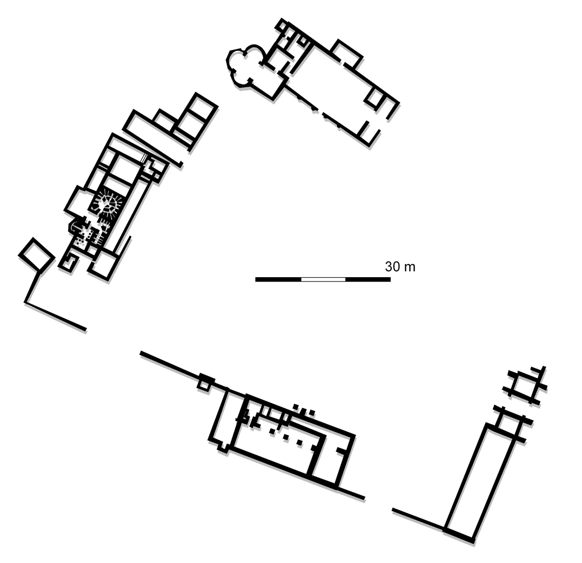
Littlecote Roman Villa is an extensive and exceptional Roman villa, with associated religious complex, at Littlecote Park just over a mile west of Hungerford, Berkshire. It has been excavated and is on display to the public in the grounds of the estate. It was situated 8 km (5.0 mi) east of the Roman town of Cunetio towards Marlborough.
Excerpt from Wikipedia under CC BY-SA 4.0. See the source article linked in Sources below.
Background
History
The settlement began life as a small short-lived military establishment guarding a road crossing of the River Kennet. It later became a small fortlet to protect the river Kennet route for water-borne transport. From 70 AD the road was still used and the site passed to local ownership with circular huts and in 120 a Roman-style rectangular timber building replaced them (the West Range). In 170 this was replaced by a large two-storeyed winged stone corridor villa with integral bath suite. In the 3rd century the surrounding towns and countryside prospered, reflected in major changes to the villa. In 190 a larger kitchen was added to the rear of the west range, and in 220 the central room was…
Description
At its height, the villa had around sixty rooms, two thermal bath suites, many mosaic floors and several heated hypocausts. The large courtyard villa enclosed an area of about , making it one of the largest in Britain. Many of the buildings were two storeys high and included five tall towers. The villa had a number of detached workshops and barns. The separate building with the triconch-form mosaics attached to a large courtyard building is interpreted as a religious cult centre, associated with the pagan revival under Julian the Apostate (361–363). The triconch building is very unusual and similar buildings only exist in North Africa and only much later in the sixth-century Byzantine…
Sourced from Wikipedia under CC BY-SA 4.0.
- Coordinates
- 51.4333, -1.5695
- District
- Wiltshire
- Parish
- Ramsbury
- Postcode
- RG17 0SU
- Parliamentary constituency
- East Wiltshire
- Nearest railway station
- Hungerford — 4.5 km
Sources
- osm: w259693519 (ODbL)
- wikipedia: Littlecote Roman Villa (CC BY-SA 4.0)
- commons: Littlecote plan.jpg (CC BY-SA 4.0)
Other places nearby
Roman villa of Littlecote
Hill forts · 0.1 km

Littlecote House
Historic houses · 0.5 km

Chilton Foliat
Towns & cities · 2.1 km

Froxfield Manor
Manor houses · 2.4 km

Froxfield
Villages · 2.5 km

The Pelican Public House
Historic pubs · 2.6 km

Golden Lion Gallery
Galleries · 2.7 km

Ramsbury
Towns & cities · 2.7 km
_(geograph_6445395).jpg?width=1200)
Kennet House
Historic houses · 2.8 km

Ramsbury War Memorial
Memorials & monuments · 2.8 km

Church of the Holy Cross, Ramsbury
Historic churches · 2.8 km

Picketfield Lock
Canal locks · 3.0 km
Nearby
📷 5Hill forts · South East England
Roman villa of Littlecote
Roman villa of Littlecote — Roman rural estate at Littlecote, in Ramsbury, Wiltshire, England, UK.
Flagship📷 5Historic houses · South East England
Littlecote House
Littlecote House — a Grade I-listed historic house in england-south-east, United Kingdom.
📷 5Towns & cities · South East England
Chilton Foliat
Chilton Foliat — village in Wiltshire, England, UK.
📷 5Manor houses · South East England
Froxfield Manor
Froxfield Manor — Grade II listed building-listed manor in england-south-east, United Kingdom.
📷 5📷 7Historic pubs · South East England
The Pelican Public House
The Pelican Public House in England South East, United Kingdom.
Where to eat & stay near Littlecote Roman Villa
Places to stay
 📷 6
📷 6 📷 5
📷 5Hotels · South East England
The Three Swans Hotel
The Three Swans Hotel — a hotel in england south east.
 📷 7
📷 7 📷 5
📷 5Campsites · South East England
Farncombe Farm Campsite
Farncombe Farm Campsite — a campsite in england south east.
 📷 5
📷 5 📷 5
📷 5Hotels · South East England
The Retreat at Elcot Park
The Retreat at Elcot Park — a hotel in england south east.
Places to eat & drink
📷 7Historic pubs · South East England
The Pelican Public House
The Pelican Public House in England South East, United Kingdom.
 📷 7
📷 7Restaurants · South East England
Tutti Pole
Tutti Pole — a restaurant in england south east.
 📷 7
📷 7Restaurants · South East England
The Funghi Club
The Funghi Club — a restaurant in england south east.
 📷 5
📷 5 📷 5
📷 5Historic pubs · South West England
Mason Arms Public House West Street House
Mason Arms Public House West Street House in England South West, United Kingdom.
 📷 5
📷 5Historic pubs · South East England
The Old Craven Arms
The Old Craven Arms in England South East, United Kingdom.
More forests in this region
 📷 5
📷 5Forests & woodlands · South East England
Darland Banks
Darland Banks is a forest or woodland in the United Kingdom.
.jpg?width=1200) 📷 5
📷 5Forests & woodlands · South East England
Inholms Lane Clay Pit Nature Reserve
Inholms Lane Clay Pit Nature Reserve is a forest or woodland in the United Kingdom.
 📷 5
📷 5Forests & woodlands · South East England
Jeskyns Community Woodland
Jeskyns Community Woodland is a forest or woodland in the United Kingdom.
 📷 5
📷 5Forests & woodlands · South East England
Oxmore Copse
Oxmore Copse is a forest or woodland in the United Kingdom.
Frequently asked questions
- Where is Littlecote Roman Villa?
- Littlecote Roman Villa is in South-East England, United Kingdom (postcode RG17 0SU), in the parish of Ramsbury.
- What is Littlecote Roman Villa?
- Littlecote Roman Villa is a forest or woodland in the United Kingdom.
- How do I get to Littlecote Roman Villa?
- The nearest railway station is Hungerford, about 4.5 km away. The nearest town is Chilton Foliat. Drivers can use postcode RG17 0SU.
- Is Littlecote Roman Villa a protected site?
- Yes — Littlecote Roman Villa is part of the River Kennet SSSI Site of Special Scientific Interest and the Cotswolds National Landscape (AONB).
- Is Littlecote Roman Villa free to visit?
- Yes, Littlecote Roman Villa is free to enter.
- How do I get to Littlecote Roman Villa?
- The nearest railway station is Hungerford, about 4.5 km away. Drivers can navigate to postcode RG17 0SU.