Reservoirs & lochs · Scottish Highlands
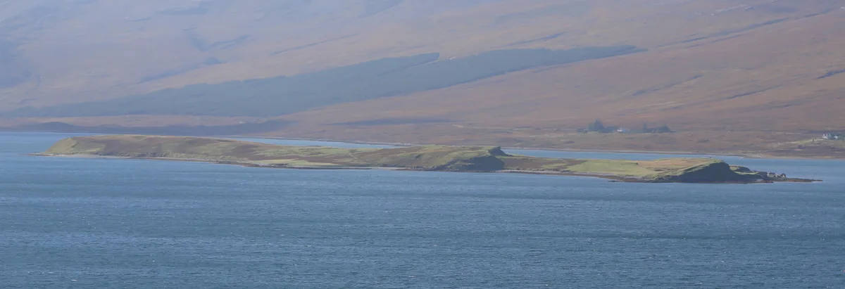
Laid
Also known as: An Leathad, Cataibh
Laid in Scotland Islands, United Kingdom.

Alan Murray Walsh — CC BY-SA 2.0 via Wikimedia Commons licence
Plan your visit
- Typical visit
- 1 h–2.5 h
- Free entry
- Dog-friendly
About
Laid is a place of interest in Scotland Islands, United Kingdom — drawn from open-data sources for visitor reference. See the linked Wikipedia article for the full description.
Photo gallery
From the Wikipedia article
Laid is a remote, linear crofting township scattered along the A838 road on the western shore of the sea loch, Loch Eriboll in Sutherland in the northern Scottish Highlands. The township is close to the north coast of Scotland in the Scottish council area of Highland around 6 miles (10 km) south of the village of Durness. The township of Portnancon is located 1 mile (1.6 km) northeast of Laid, along the A838 road. The township was first settled in 1832, being created to house residents of Eriboll who had been cleared from the eastern shore of Loch Erriboll. The population has always been low with a small number of crofts on the land. The primary school closed in 1955. The area was considered as a site for a proposed "superquarry" during the 1990s. The plan would have meant a Liechtenstein company, Vibel SA, develop the area for quarrying for aggregate use. The plans were dropped and Highland Council excluded the possibility of a major quarry in the area in its late 1990s structure plan, although plans for some mineral development continued.
Excerpt from Wikipedia under CC BY-SA 4.0. See the source article linked in Sources below.
- Coordinates
- 58.4913, -4.7272
- District
- Highland
- Postcode
- IV27 4UN
- Parliamentary constituency
- Caithness, Sutherland and Easter Ross
Sources
- wikidata: Q6473742 (CC0)
- wikipedia: Laid, Sutherland (CC BY-SA 4.0)
Other places nearby

Choraidh Croft
Caravan parks · 0.3 km
Eilean Choraidh
Islands · 1.5 km

H48 Stones
Memorials & monuments · 1.7 km
HMS Hood Stones
Memorials & monuments · 1.7 km

HMS Bulwark Stones
Memorials & monuments · 1.9 km
HMS Sutherland Stones
Memorials & monuments · 1.9 km
Portnancon
Villages · 2.0 km
HMS Blake Stones
Memorials & monuments · 2.0 km

Loch Eriboll
Natural landmarks · 2.4 km

Portnancon
Piers · 2.7 km

Meall an Fheadain
Mountains & hills · 2.8 km

Eilean Dubh
Islands · 3.2 km
Nearby
📷 5Caravan parks · Scottish Highlands
Choraidh Croft
Choraidh Croft — a caravan park in scotland highlands.
Flagship📷 5Islands · Scottish Highlands
Eilean Choraidh
Eilean Choraidh — island in Loch Eriboll, Sutherland, Highland, Scotland, UK.
📷 5Memorials & monuments · Scottish Islands
H48 Stones
H48 Stones — a memorial in scotland-islands, United Kingdom.
📷 5Memorials & monuments · Scottish Islands
HMS Hood Stones
HMS Hood Stones — a memorial in scotland-islands, United Kingdom.
📷 5Memorials & monuments · Scottish Islands
HMS Bulwark Stones
HMS Bulwark Stones — a memorial in scotland-islands, United Kingdom.
📷 5Memorials & monuments · Scottish Islands
HMS Sutherland Stones
HMS Sutherland Stones — a memorial in scotland-islands, United Kingdom.
Where to eat & stay near Laid
Places to stay
📷 5Caravan parks · Scottish Highlands
Choraidh Croft
Choraidh Croft — a caravan park in scotland highlands.
 📷 5
📷 5Hostels · Scottish Islands
Durness Youth Hostel
Durness Youth Hostel — a hostel in scotland islands.
 📷 5
📷 5Hostels · Scottish Islands
Lazy Crofter Bunkhouse/Hostel
Lazy Crofter Bunkhouse/Hostel — a hostel in scotland islands.
📷 5 📷 5
📷 5Campsites · Scottish Islands
Sango Sands
Sango Sands — a campsite in scotland islands.
 📷 5
📷 5Caravan parks · Scottish Islands
Balnakeil Motorhome Stopover
Balnakeil Motorhome Stopover — a caravan park in scotland islands.
More places in this region
 Flagship📷 3
Reservoirs & lochs · Scottish Highlands
Loch Ericht
Loch Ericht — lake in Perth and Kinross, and Highland, Scotland, UK, outflows to River Ericht.
 Flagship📷 3
Reservoirs & lochs · Scottish Highlands
Loch Shin
Loch Shin — reservoir in Highland, Scotland, UK, outflows to the River Shin.
 📷 4
📷 4Reservoirs & lochs · Scottish Highlands
Backwater Reservoir
Backwater Reservoir — lake in Angus, Scotland, UK.
 📷 3
📷 3Reservoirs & lochs · Scottish Highlands
Blackwater Reservoir
Blackwater Reservoir — reservoir in Highland, Scotland, UK, outflows to the River Leven.
Frequently asked questions
- Where is Laid?
- Laid is in the Scottish Highlands, United Kingdom (postcode IV27 4UN).
- What is Laid?
- Laid in Scotland Islands, United Kingdom.
- How do I get to Laid?
- Drivers can use postcode IV27 4UN.
- Is Laid free to visit?
- Yes, Laid is free to enter.
- How do I get to Laid?
- Drivers can navigate to postcode IV27 4UN. It sits within the Caithness, Sutherland and Easter Ross parliamentary constituency.