
Villages · North East England
Kirkheaton
In or near Matfen.
Kirkheaton — a village in scotland lowlands.

Les Hull — CC BY-SA 2.0 via Wikimedia Commons licence

Plan your visit
- Typical visit
- 1 h–2 h
About
A British village — settlements of this size traditionally cluster a green, parish church, pub and post office around historic land routes.
Photo gallery
Protected designations
- Site of Special Scientific Interest: Northumberland Shore SSSI
Designations sourced from Natural England open data under OGL v3.
Place summary
Kirkheaton is a village located in the Scottish Lowlands. It features typical rural architecture and a small community atmosphere. The surrounding landscape includes rolling hills and agricultural land, characteristic of the region. Visitors can expect a quiet setting, ideal for walking and exploring the local countryside.
AI-generated from the structured facts on this page (operator, designation, listing, era). Not a substitute for visiting.
- Coordinates
- 55.0833, -1.9667
- District
- Northumberland
- Parish
- Capheaton
- Postcode
- NE19 2DQ
- Parliamentary constituency
- Hexham
Sources
- manual: geonames-2645274 (CC BY 4.0)
Other places nearby
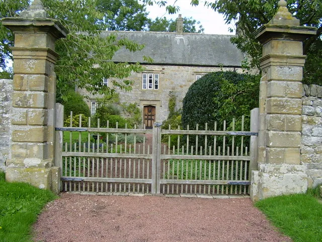
Kirkheaton Manor
Stately homes · 0.9 km

Moot Law
Mountains & hills · 1.3 km

Ryal
Historic churches · 2.3 km

Ingoe
Villages · 2.4 km

South Hall
Historic houses · 2.5 km

Standing stone with cup markings, 230m south of Sandyway Heads
Windmills · 2.8 km

Bavington
Other places · 3.3 km

Bavington Hall
Historic houses · 3.7 km

Hallington
Other places · 3.9 km

Little Bavington
Natural landmarks · 4.0 km

Hallington Hall
Historic houses · 4.0 km

Capheaton Castle
Literary houses · 4.3 km
Nearby
Flagship📷 3Stately homes · North East England
Kirkheaton Manor
Kirkheaton Manor — house in Kirkheaton, Northumberland, England, UK.
📷 5📷 5📷 5📷 3Historic houses · North East England
South Hall
South Hall — house in Matfen, Northumberland, England, UK.
📷 5Windmills · North East England
Standing stone with cup markings, 230m south of Sandyway Heads
Standing stone with cup markings, 230m south of Sandyway Heads — a post mill in scotland-lowlands, United Kingdom.
Where to eat & stay near Kirkheaton
Places to stay
 📷 5
📷 5Caravan parks · North East England
Well House CAMC CL
Well House CAMC CL — a caravan park in scotland lowlands.
 📷 5
📷 5Caravan parks · North East England
Elf Hills CL Site
Elf Hills CL Site — a caravan park in scotland lowlands.
 📷 5
📷 5Campsites · North East England
Barrasford Park Camping Site
Barrasford Park Camping Site — a campsite in scotland lowlands.
📷 5Caravan parks · North East England
Barrasford Park Caravan Site
Barrasford Park Caravan Site — a caravan park in scotland lowlands.
 📷 5
📷 5Caravan parks · North East England
Wellhouse Farm Caravan Park
Wellhouse Farm Caravan Park — a caravan park in scotland lowlands.
📷 5Campsites · North East England
Wellhouse Farm Camping site
Wellhouse Farm Camping site — a campsite in scotland lowlands.
Places to eat & drink
 📷 5
📷 5 📷 7
📷 7Historic pubs · North East England
The Vicars Pele
The Vicars Pele in Scotland Lowlands, United Kingdom.
 📷 5
📷 5Historic pubs · North East England
The Crown And Anchor
The Crown And Anchor in Scotland Lowlands, United Kingdom.
 📷 5
📷 5Historic pubs · North East England
The Seven Stars Public House
The Seven Stars Public House in Scotland Lowlands, United Kingdom.
 📷 5
📷 5Historic pubs · North East England
Wellington Inn
Wellington Inn in Scotland Lowlands, United Kingdom.
 📷 6
📷 6More places in this region
 📷 5
📷 5 📷 5
📷 5 📷 5
📷 5 📷 5
📷 5Frequently asked questions
- Where is Kirkheaton?
- Kirkheaton is in North-East England, United Kingdom (postcode NE19 2DQ), in the parish of Capheaton.
- What is Kirkheaton?
- Kirkheaton — a village in scotland lowlands.
- How do I get to Kirkheaton?
- The nearest town is Matfen. Drivers can use postcode NE19 2DQ.
- Is Kirkheaton a protected site?
- Yes — Kirkheaton is part of the Northumberland Shore SSSI Site of Special Scientific Interest.
- How do I get to Kirkheaton?
- Drivers can navigate to postcode NE19 2DQ. It sits within the Hexham parliamentary constituency.