
Caves · Yorkshire & the Humber
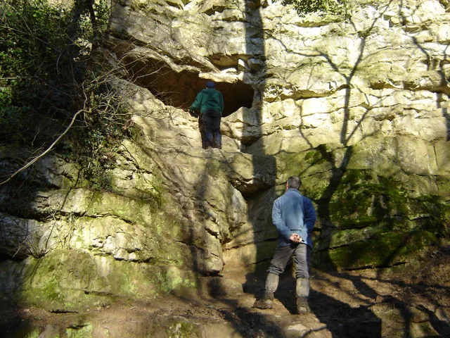
Kirkdale Cave
In or near Wombleton.
Kirkdale Cave is a cave in the United Kingdom.

Wikimedia Commons contributors — see linked file page for photographer and licence licence

Plan your visit
- Typical visit
- 45 min–1.5 h
- Free entry
- Dog-friendly
About
Kirkdale Cave is a named cave entrance in the United Kingdom. Coordinates: 54.2616°, -0.9601°. This entry is part of The Great Britain Guide, a free, ad-free, open-data tourist directory.
Photo gallery
Protected designations
- Site of Special Scientific Interest: Kirkdale Cave SSSI
Designations sourced from Natural England open data under OGL v3.
From the Wikipedia article
Kirkdale Cave is a cave and fossil site located in Kirkdale near Kirkbymoorside in the Vale of Pickering, North Yorkshire, England. It was discovered by workmen in 1821, and found to contain fossilized bones of a variety of mammals from the Eemian interglacial (globally known as the Last Interglacial, ~130-115,000 years ago), when temperatures were comparable to contemporary times, including animals currently absent from Britain or globally extinct, including hippopotamuses (amongst the farthest north any such remains have been found), straight-tusked elephants, the narrow-nosed rhinoceros, and cave hyenas. William Buckland analyzed the cave and its contents in December 1821 and determined that the bones were the remains of animals brought in by hyenas who used it for a den, and not a result of the Biblical flood floating corpses in from distant lands, as he had first thought. His reconstruction of an ancient ecosystem from detailed analysis of fossil evidence was admired at the time, and considered to be an example of how geo-historical research should be done. The cave was extended from its original length of 175 metres (574 ft) to 436 metres (1,430 ft) by Scarborough Caving Club in 1995. A survey was published in Descent magazine.
Excerpt from Wikipedia under CC BY-SA 4.0. See the source article linked in Sources below.
- Coordinates
- 54.2616, -0.9601
- District
- North Yorkshire
- Parish
- Welburn (Kirkbymoorside & Dales Ward)
- Postcode
- YO62 7HF
- Parliamentary constituency
- Thirsk and Malton
Sources
- osm: n9013977135 (ODbL)
- wikipedia: Kirkdale Cave (CC BY-SA 4.0)
- commons: Kirkdale Cave - geograph.org.uk - 1072214.jpg (CC BY-SA 4.0)
Other places nearby
Kirkdale Cave
Mountains & hills · 0.0 km
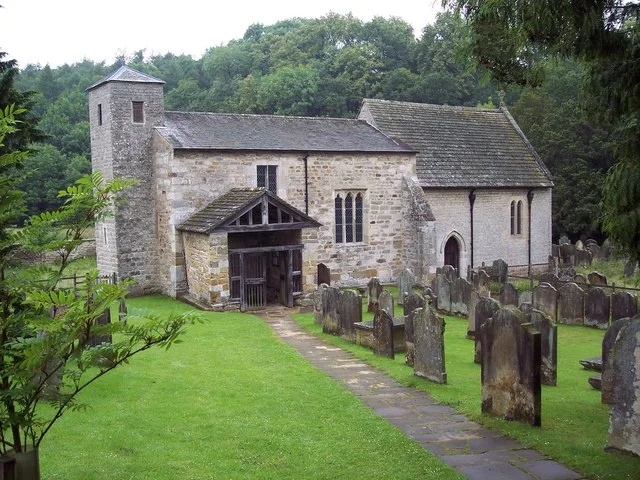
St Gregory's Minster
Historic churches · 0.2 km

Tilehouse Bridge
Historic bridges · 0.6 km

Howkeld Mill
Mills · 0.9 km

Stony Cross
Memorials & monuments · 1.3 km

Welburn
Villages · 1.4 km

Wombleton
Towns & cities · 1.8 km

Kirkbymoorside
Museums · 1.9 km

Windmill At Rear Of No 17
Windmills · 2.0 km

Neville Castle
Castles · 2.1 km
Neville Castle, 430m north west of the parish church
Castles · 2.1 km

Nawton
Villages · 2.2 km
Nearby
📷 3Mountains & hills · Yorkshire & the Humber
Kirkdale Cave
Kirkdale Cave — Cave in North Yorkshire, England.
📷 5Historic churches · Yorkshire & the Humber
St Gregory's Minster
St Gregory's Minster — Anglo-Saxon church in Kirkdale near Kirkbymoorside, Vale of Pickering, North Yorkshire, England, UK.
📷 3Historic bridges · Yorkshire & the Humber
Tilehouse Bridge
Tilehouse Bridge — Grade II listed building-listed bridge in england-yorkshire, United Kingdom.
📷 3Mills · Yorkshire & the Humber
Howkeld Mill
Howkeld Mill — mill in Welburn, Ryedale, North Yorkshire, England, UK.
📷 3Memorials & monuments · Yorkshire & the Humber
Stony Cross
Stony Cross — a memorial in Yorkshire & the Humber, United Kingdom.
📷 5Where to eat & stay near Kirkdale Cave
Places to stay
 📷 5
📷 5Caravan parks · Yorkshire & the Humber
Wrens of Ryedale Touring Park
Wrens of Ryedale Touring Park — a caravan park in england yorkshire.
📷 5 📷 5
📷 5Campsites · Yorkshire & the Humber
Wombleton Caravan Park
Wombleton Caravan Park — a campsite in england yorkshire.
 📷 5
📷 5Caravan parks · Yorkshire & the Humber
Foxholme Caravan Park
Foxholme Caravan Park — a caravan park in england yorkshire.
 📷 5
📷 5Caravan parks · Yorkshire & the Humber
Hutton-le-Hole Caravan Park
Hutton-le-Hole Caravan Park — a caravan park in england yorkshire.
 📷 5
📷 5Places to eat & drink
 📷 5
📷 5Restaurants · Yorkshire & the Humber
The Star Inn
The Star Inn — a restaurant in england yorkshire.
 📷 7
📷 7Historic pubs · Yorkshire & the Humber
The Black Swan And Railings To Front
The Black Swan And Railings To Front in England Yorkshire, United Kingdom.
 📷 5
📷 5Historic pubs · Yorkshire & the Humber
The Blacksmith's Arms Restaurant
The Blacksmith's Arms Restaurant in England Yorkshire, United Kingdom.
 📷 7
📷 7Historic pubs · Yorkshire & the Humber
The Rose Inn
The Rose Inn in England Yorkshire, United Kingdom.
 📷 7
📷 7Restaurants · Yorkshire & the Humber
Capplemans
Capplemans — a restaurant in england yorkshire.
 📷 7
📷 7More caves in this region
 📷 3
📷 3 📷 3
📷 3 📷 3
📷 3 📷 3
📷 3Frequently asked questions
- Where is Kirkdale Cave?
- Kirkdale Cave is in Yorkshire, United Kingdom (postcode YO62 7HF), in the parish of Welburn (Kirkbymoorside & Dales Ward).
- What is Kirkdale Cave?
- Kirkdale Cave is a cave in the United Kingdom.
- How do I get to Kirkdale Cave?
- The nearest town is Wombleton. Drivers can use postcode YO62 7HF.
- Is Kirkdale Cave a protected site?
- Yes — Kirkdale Cave is part of the Kirkdale Cave SSSI Site of Special Scientific Interest.
- Is Kirkdale Cave free to visit?
- Yes, Kirkdale Cave is free to enter.
- How do I get to Kirkdale Cave?
- Drivers can navigate to postcode YO62 7HF. It sits within the Thirsk and Malton parliamentary constituency.