
Holy wells · East Midlands
Jewry Wall
In or near Leicester.
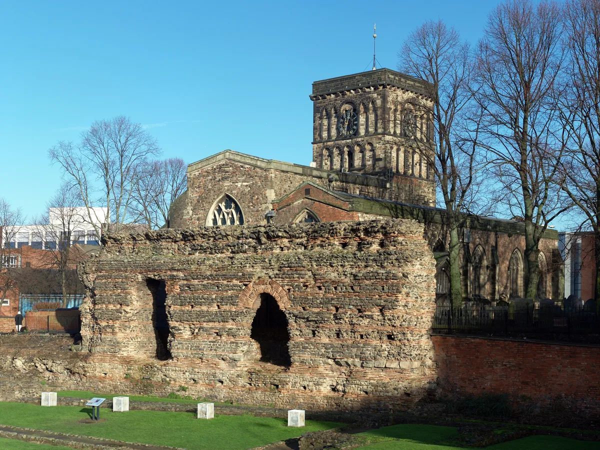
Jewry Wall — Grade I listed structure in Leicester, England, UK.

Wikimedia Commons contributors — see linked file page for photographer and licence licence
.jpg)
Plan your visit
- Typical visit
- 15 min–30 min
- Nearest railway station
- Leicester · 1.2 km
- Free entry
- Family-friendly
- Dog-friendly
- Wheelchair accessible
Getting there & planning your visit
To visit Jewry Wall in Leicester, the nearest railway station is Leicester, located 1.2 km away. Entry is free, and the site is accessible for wheelchair users. The postcode for sat-nav is LE1 4LB.
About
Jewry Wall is a holy well in the United Kingdom. Heritage designation: Grade I listed building. Owned by English Heritage. Managed by English Heritage. Part of Jewry Wall: remains of a Roman bath house, palaestra and Anglo-Saxon church. Wikidata describes it as: "Grade I listed structure in Leicester, England, UK". Coordinates: 52.6350°, -1.1411°.
Photo gallery
See it from the streetimagery from 2021
Imagery © Mapillary contributors, CC BY-SA 4.0
From English Heritage
A length of Roman bath-house wall over 9 metres (30 feet) high, near a museum displaying the archaeology of Leicester and its region.
Read more on the official property page.
From the Wikipedia article
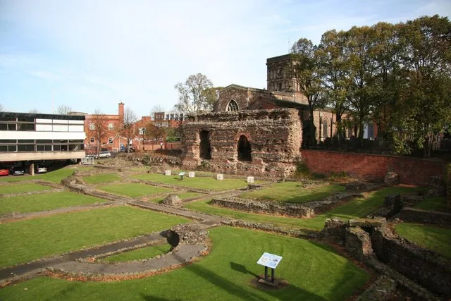
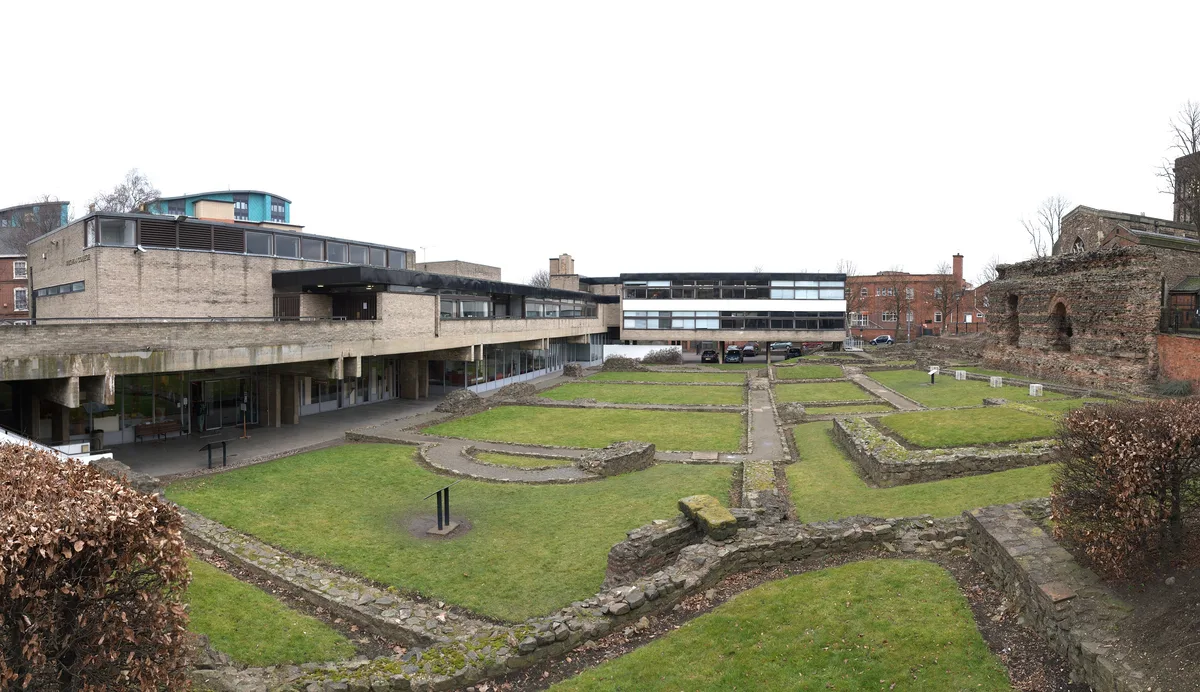
The Jewry Wall is a substantial ruined wall of 2nd-century Roman masonry, with two large archways, in Leicester, England. It stands alongside St Nicholas' Circle and St Nicholas' Church. It formed the west wall of a public building in Ratae Corieltauvorum (Roman Leicester), alongside public baths, the foundations of which were excavated in the 1930s and are also open to view. The wall gives its name to the adjacent Jewry Wall Museum.
Excerpt from Wikipedia under CC BY-SA 4.0. See the source article linked in Sources below.
Background
Description
The wall is an impressive example of standing Roman masonry. It dates to approximately 125–130 AD. It measures long, high and thick. It is among the largest pieces of surviving civil Roman architecture in Britain, and is comparable to the "Old Work" at Wroxeter. The structure comprises alternate bands of Roman brick and coursed masonry, of local granite, limestone and sandstone. In the centre of the wall are two large arched openings about wide and high, and there are further arched alcoves on the eastern side. The wall lies immediately to the west of St Nicholas' Church, which includes in its late Saxon and early medieval fabric much reused Roman brick and masonry. The remains of the Roman…
Visiting
The Jewry Wall features as the "Old Bathhouse" in the 2020 video game Assassin's Creed Valhalla. It is in the town of ', the form of the name of Leicester that appears in the Domesday Book of 1086.
Sourced from Wikipedia under CC BY-SA 4.0.
- Coordinates
- 52.6350, -1.1411
- District
- Leicester
- Parish
- Leicester, unparished area
- Postcode
- LE1 4LB
- Parliamentary constituency
- Leicester West
- Phone
- 01162 254971 (Jewry Wall Museum)
- Nearest railway station
- Leicester — 1.2 km
- Opening
- Free to view from St Nicholas' Walk during daylight hours
- Official site
- www.english-heritage.org.uk
Sources
- wikidata: Q6190177 (CC0)
- wikipedia: Jewry Wall (CC BY-SA 4.0)
- commons: Jewry Wall (closeup).jpg (CC BY-SA 4.0)
Other places nearby
St Nicholas' Church, Leicester
Historic churches · 0.0 km
Ratae Corieltauvorum
Hill forts · 0.0 km
Jewry Wall Museum
Museums · 0.0 km
Guru Nanak Gurdwara
Historic churches · 0.1 km

Hamidiye Camii
Historic churches · 0.1 km

The High Cross
Memorials & monuments · 0.2 km

Wyggeston House
Historic houses · 0.2 km

Mary Hehir
Memorials & monuments · 0.2 km

Leicester Guildhall
Historic houses · 0.2 km

Alderman Newton's School
Natural landmarks · 0.2 km

West Bridge Mills
Historic bridges · 0.2 km

Highcross Beacons
Public art & sculpture · 0.2 km
Nearby
📷 5Historic churches · East Midlands
St Nicholas' Church, Leicester
St Nicholas' Church, Leicester — Grade I listed church in Leicester, United Kingdom.
📷 3Hill forts · East Midlands
Ratae Corieltauvorum
Ratae Corieltauvorum — former Roman town on the site of Leicester.
📷 4Museums · East Midlands
Jewry Wall Museum
Jewry Wall Museum — museum in Leicester, England, United Kingdom.
Historic churches · East Midlands
Guru Nanak Gurdwara
Guru Nanak Gurdwara — a church in england east midlands.
📷 5Historic churches · East Midlands
Hamidiye Camii
Hamidiye Camii — a church in East Midlands, United Kingdom.
📷 3Memorials & monuments · East Midlands
The High Cross
The High Cross — a memorial in East Midlands, United Kingdom.
Where to eat & stay near Jewry Wall
Places to stay
 📷 7
📷 7Hotels · East Midlands
Holiday Inn Express
Holiday Inn Express — a hotel in england west midlands. 3-star. Brand: Holiday Inn Express.
 📷 5
📷 5Hotels · East Midlands
Winstanley House
Winstanley House — a hotel in england west midlands.
 📷 5
📷 5Caravan parks · East Midlands
Unicorn Mobile Home Park
Unicorn Mobile Home Park — a caravan park in england west midlands.
 📷 5
📷 5Caravan parks · East Midlands
Inglenook Park (Mobile Home Park)
Inglenook Park (Mobile Home Park) — a caravan park in england west midlands.
 📷 5
📷 5Hotels · East Midlands
Blaby Westfield Hotel
Blaby Westfield Hotel — a hotel in england west midlands.
 📷 5
📷 5Caravan parks · East Midlands
Cropston Caravan Site
Cropston Caravan Site — a caravan park in england west midlands.
Places to eat & drink
 📷 5
📷 5 📷 5
📷 5Historic pubs · East Midlands
Market Tavern
Market Tavern in England East Midlands, United Kingdom.
 📷 5
📷 5Restaurants · East Midlands
Peter Pizzeria
Peter Pizzeria — a restaurant in england west midlands. Cuisine: sandwich;pizza.
 📷 5
📷 5Restaurants · East Midlands
Pepe's Piri Piri
Pepe's Piri Piri — a restaurant in england west midlands. Cuisine: burger;sandwich;indian;asian;chicken;ice cream. 5-star.
 📷 7
📷 7Historic pubs · East Midlands
Rothley Court
Rothley Court in England East Midlands, United Kingdom.
 📷 5
📷 5Historic pubs · East Midlands
Narborough Arms
Narborough Arms in England East Midlands, United Kingdom.
More places run by English Heritage
 Flagship📷 10
Museums · London
Kenwood House
Kenwood House — art museum and historic house in Hampstead, London.
 📷 5
📷 5Galleries · London
Apsley House
Apsley House — London townhouse of the Dukes of Wellington.
 📷 5
📷 5Castles · London
Eynsford Castle
Eynsford Castle — castle, now ruinous, in Eynsford, Kent, England, UK.
 📷 5
📷 5Museums · London
Jewel Tower
Jewel Tower — medieval tower in Westminster, London, England, UK.
More places in this region
_(geograph_7136563).jpg?width=1200) 📷 5
📷 5Holy wells · East Midlands
Wall And Gatepiers To Barn Hill House
Wall And Gatepiers To Barn Hill House — wall in Stamford, South Kesteven, England, UK.
_(geograph_7158446).jpg?width=1200) 📷 5
📷 5Holy wells · East Midlands
Wall And Gates To No 2
Wall And Gates To No 2 — wall in Stamford, South Kesteven, England, UK.
 📷 3
📷 3Holy wells · East Midlands
Boundary Wall Extending Along Eastern Boundary Of Footpath Between Number 65 And The Churchyard Of St Bartholomew's Church
Boundary Wall Extending Along Eastern Boundary Of Footpath Between Number 65 And The Churchyard Of St Bartholomew's Church — wall in Chesterfield, Derbyshire, England, UK.
 📷 3
📷 3Holy wells · East Midlands
Close Wall between Number 16a Minster Yard and the Deanery
Close Wall between Number 16a Minster Yard and the Deanery — Grade I listed wall in Lincoln, United Kingdom.
Frequently asked questions
- Where is Jewry Wall?
- Jewry Wall is in the East Midlands, United Kingdom (postcode LE1 4LB), in the parish of Leicester, unparished area.
- What is Jewry Wall?
- Jewry Wall — Grade I listed structure in Leicester, England, UK.
- How do I get to Jewry Wall?
- The nearest railway station is Leicester, about 1.2 km away. The nearest town is Leicester. Drivers can use postcode LE1 4LB.
- Who runs Jewry Wall?
- Jewry Wall is operated by English Heritage.
- Is Jewry Wall a listed building?
- Jewry Wall is officially recognised as Grade I listed building listed.
- Is Jewry Wall free to visit?
- Yes, Jewry Wall is free to enter.
- How do I get to Jewry Wall?
- The nearest railway station is Leicester, about 1.2 km away. Drivers can navigate to postcode LE1 4LB.