
Islands · Scottish Islands
Island of Stroma
In or near John o'Groats.
Island of Stroma — island off the northern coast of the mainland of Scotland, UK.

Wikimedia Commons contributors — see linked file page for photographer and licence licence

Plan your visit
- Typical visit
- 4 h–12 h
- Free entry
- Dog-friendly
Getting there & planning your visit
The Island of Stroma is located in the Scottish Islands at coordinates 58.6856° N latitude and -3.1167° W longitude. There is no nearest railway station or postcode provided, and entry to the island is free. Accessibility details are not specified.
About
Island of Stroma is a island in the United Kingdom. It covers approximately 375 km². Part of British Isles. Wikidata describes it as: "island off the northern coast of the mainland of Scotland, UK". Coordinates: 58.6856°, -3.1167°.
Photo gallery
From the Wikipedia article
Stroma is an uninhabited island in the Pentland Firth, between Orkney and the mainland of Scotland. It forms part of the civil parish of Canisbay in Caithness, in the Highland council area. The name comes from the Old Norse Straumey, meaning "island in the stream". Ancient stone structures testify to the presence of Stroma's earliest residents, while a Norse presence around 900–1,000 years ago is recorded in the Orkneyinga Saga. It has been politically united with Caithness since at least the 15th century. Although Stroma lies only a few miles off the Scottish coast, the savage weather and ferociously strong tides of the Pentland Firth meant that the island's inhabitants were very isolated, causing them to be largely self-sufficient, trading agricultural produce and fish with the mainlanders. Most of the islanders were fishermen and crofters; some also worked as maritime pilots to guide vessels through the treacherous waters of the Pentland Firth. The tides and currents meant that shipwrecks were frequent—the most recent occurring in 1993—and salvage provided an additional though often illegal supplement to the islanders' incomes. A lighthouse was built on Stroma in 1890 and still operates under automation. Stroma is now abandoned, with the houses of its former inhabitants unoccupied and falling into ruin. Its population fell gradually through the first half of the 20th century as inhabitants drifted away to seek opportunities elsewhere, as economic problems and Stroma's isolation made life on the island increasingly unsupportable. From an all-time peak of 375 people in 1901, the population fell to just 12 by 1961 and the last islanders left at the end of the following year. Stroma's final abandonment came in 1997 when the lighthouse keepers and their families departed. The island is now owned by one of its former inhabitants, who uses it to graze sheep.
Excerpt from Wikipedia under CC BY-SA 4.0. See the source article linked in Sources below.
Background
Visiting
There is currently no easy way for the public to visit the island, but there are plans for seasonal daily boat trips to start in the summer of 2026.
Sourced from Wikipedia under CC BY-SA 4.0.
- Coordinates
- 58.6856, -3.1167
- Official site
- d3lmsxlb5aor5x.cloudfront.net
Sources
- wikidata: Q1429561 (CC0)
- wikipedia: Stroma, Scotland (CC BY-SA 4.0)
- commons: Stromalighthouse.jpg (CC BY-SA 4.0)
Featured in these 3 guides
Itinerary
Britain's wild islands: 7 days in the Hebrides
Skye, Mull, Iona, Staffa — a slow island-hopping itinerary.
Itinerary
Britain's lesser-known islands
Beyond Skye and the Isle of Wight — eight quieter island destinations.
Itinerary
Britain's tidal causeways
Eight places you can only reach at low tide.
Other places nearby

The Gloup
Caves · 0.4 km

Stroma, Bught o' Camm
Vineyards · 0.6 km

Bught O' Camm
Archaeological sites · 0.6 km
Little Gloup
Caves · 0.7 km

Tree Geo
Natural landmarks · 1.0 km
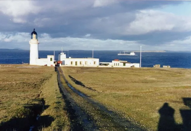
Stroma Lighthouse
Lighthouses · 1.2 km
Cairn Hill
Mountains & hills · 1.2 km
Cairn Hill (Stroma)
Mountains & hills · 1.2 km

Mestag Castle
Castles · 2.2 km

MeyGen
Islands · 3.1 km

Pentland Firth
Natural landmarks · 3.4 km

MV Cemfjord
Other places · 3.7 km
Nearby
📷 3📷 5Vineyards · Scottish Islands
Stroma, Bught o' Camm
Stroma, Bught o' Camm — a UK vineyard in scotland islands, producing English or Welsh wine from cool-climate grape varieties.
📷 3Archaeological sites · Scottish Islands
Bught O' Camm
Bught O' Camm — a archaeological in scotland-islands, United Kingdom.
📷 3📷 5📷 3Lighthouses · Scottish Islands
Stroma Lighthouse
Stroma Lighthouse — lighthouse in Caithness, Scotland.
Where to eat & stay near Island of Stroma
Places to stay
 📷 5
📷 5 📷 5
📷 5Caravan parks · Scottish Islands
Natural Retreats
Natural Retreats — a caravan park in scotland islands.
 📷 5
📷 5Campsites · Scottish Islands
John O'Groats Caravan and Camping Site
John O'Groats Caravan and Camping Site — a campsite in scotland islands.
 📷 5
📷 5Campsites · Scottish Islands
Ferry View Campsite
Ferry View Campsite — a campsite in scotland islands.
 📷 5
📷 5 📷 5
📷 5Campsites · Scottish Islands
WIndhaven
WIndhaven — a campsite in scotland islands.
More places in this region
 📷 5
📷 5Islands · Scottish Islands
Bac Beag
Bac Beag — Scottish island, part of the Treshnish Isles in the Inner Hebrides.
 📷 5
📷 5Islands · Scottish Islands
Bac Mòr
Bac Mòr — island in Argyll and Bute, Scotland, UK, one of the Treshnish Isles.
 Flagship📷 3
Islands · Scottish Islands
Baleshare
Baleshare — flat tidal island in the Outer Hebrides, Scotland, UK.
 Flagship📷 5
Islands · Scottish Islands
Barra
Barra — island in Outer Hebrides, Scotland, UK.
Frequently asked questions
- Where is Island of Stroma?
- Island of Stroma is in the Scottish Islands, United Kingdom.
- What is Island of Stroma?
- Island of Stroma — island off the northern coast of the mainland of Scotland, UK.
- How do I get to Island of Stroma?
- The nearest town is John o'Groats. Its coordinates are 58.6856°, -3.1167°.
- Is Island of Stroma free to visit?
- Yes, Island of Stroma is free to enter.