
Archaeological sites · North West England
Ingleston Mote
In or near Cargenbridge.
Ingleston Mote — a archaeological in scotland-lowlands, United Kingdom.

Gordon Brown — CC BY-SA 2.0 via Wikimedia Commons licence

Plan your visit
- Typical visit
- 45 min–1.5 h
- Free entry
- Dog-friendly
About
Ingleston Mote is a archaeological located in scotland-lowlands, United Kingdom. Sourced from OpenStreetMap (ODbL licence); see local listings for visitor information, opening hours and admission details.
Photo gallery
Protected designations
- Ramsar wetland: Upper Solway Flats & Marshes
Designations sourced from Natural England open data under OGL v3.
Place summary
Ingleston Mote is an archaeological site located in the Scottish Lowlands. It features a motte, a type of earthwork castle, indicative of medieval fortifications in the region. The site is significant for its historical context and landscape archaeology.
AI-generated from the structured facts on this page (operator, designation, listing, era). Not a substitute for visiting.
- Coordinates
- 54.9700, -3.5929
- District
- Dumfries and Galloway
- Postcode
- DG2 8DG
- Parliamentary constituency
- Dumfries and Galloway
Sources
- osm: node/13671480281 (ODbL)
Other places nearby

Loch Hill
Mountains & hills · 1.0 km

Airds Hill
Mountains & hills · 1.5 km

Kirkconnell
Villages · 1.5 km
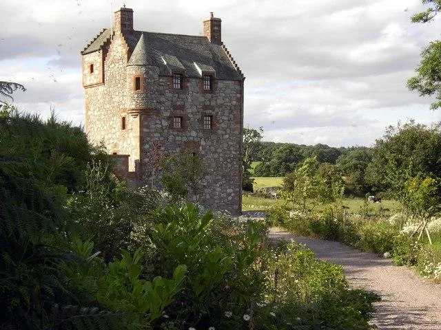
Abbot's Tower
Castles · 1.7 km

St Mary's R.C. Church, New Abbey
Historic churches · 1.8 km

New Abbey Parish Church, Sweetheart Abbey, New Abbey
Historic churches · 1.8 km
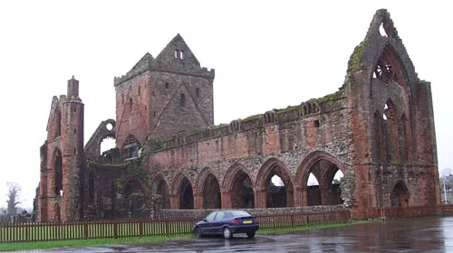
Sweetheart Abbey
Abbeys & priories · 1.9 km

Sweetheart Abbey
Cathedrals · 1.9 km

New Abbey
Villages · 2.2 km

New Abbey, Monksmill
Watermills · 2.2 km

New Abbey Corn Mill
Watermills · 2.2 km

Old House, New Abbey
Historic houses · 2.2 km
Nearby
📷 5Mountains & hills · North West England
Loch Hill
Loch Hill — a hill or mountain in scotland lowlands.
📷 5Mountains & hills · Scottish Lowlands
Airds Hill
Airds Hill — mountain in scotland lowlands. Elevation: 58 m.
📷 5📷 3Castles · Scottish Lowlands
Abbot's Tower
Abbot's Tower — castle in Dumfries and Galloway, Scotland, UK.
📷 5Historic churches · North West England
St Mary's R.C. Church, New Abbey
St Mary's R.C. Church, New Abbey — category B listed building-listed church in scotland-lowlands, United Kingdom.
📷 5Historic churches · North West England
New Abbey Parish Church, Sweetheart Abbey, New Abbey
New Abbey Parish Church, Sweetheart Abbey, New Abbey — category B listed building-listed church in scotland-lowlands, United Kingdom.
Where to eat & stay near Ingleston Mote
Places to stay
 📷 5
📷 5Campsites · Scottish Lowlands
Marthrown of Mabie
Marthrown of Mabie — a campsite in scotland lowlands.
📷 5Hostels · Scottish Lowlands
Marthrown of Mabie
Marthrown of Mabie — a hostel in scotland lowlands.
 📷 5
📷 5Caravan parks · Scottish Lowlands
Camping Beeswing
Camping Beeswing — a caravan park in scotland lowlands.
 📷 3
📷 3Hotels · Scottish Lowlands
Comlongon Castle (Hotel)
Comlongon Castle (Hotel) — a hotel in scotland lowlands.
 📷 5
📷 5Caravan parks · Scottish Lowlands
Dumfries Caravan Park
Dumfries Caravan Park — a caravan park in scotland lowlands.
 📷 5
📷 5Caravan parks · North West England
Sandyhills Bay Caravan Park
Sandyhills Bay Caravan Park — a caravan park in scotland lowlands.
Places to eat & drink
 📷 5
📷 5Historic pubs · Scottish Lowlands
Queen O' The South Public House, 8-10 Nith Place, Dumfries
Queen O' The South Public House, 8-10 Nith Place, Dumfries in Scotland Lowlands, United Kingdom.
 📷 5
📷 5Historic pubs · Scottish Lowlands
The Globe Inn, 56 High Street, Dumfries
The Globe Inn, 56 High Street, Dumfries in Scotland Lowlands, United Kingdom.
 📷 5
📷 5Historic pubs · Scottish Lowlands
73-77 English Street, Dumfries
73-77 English Street, Dumfries in Scotland Lowlands, United Kingdom.
 📷 5
📷 5Historic pubs · Scottish Lowlands
75 Friars Vennel, Dumfries
75 Friars Vennel, Dumfries in Scotland Lowlands, United Kingdom.
 📷 7
📷 7Historic pubs · Scottish Lowlands
Rob Roy Public House, 63-65 Queensberry Street, Dumfries
Rob Roy Public House, 63-65 Queensberry Street, Dumfries in Scotland Lowlands, United Kingdom.
 📷 7
📷 7Historic pubs · Scottish Lowlands
The Farmers Inn
The Farmers Inn in Scotland Lowlands, United Kingdom.
More archaeological sites in this region
 📷 3
📷 3Archaeological sites · North West England
Early medieval sculptural fragments in St Mary's churchyard
Early medieval sculptural fragments in St Mary's churchyard — archaeological site in Sandbach, Cheshire East, England, UK.
 📷 3
📷 3Archaeological sites · North West England
Gaddum's Wood
Gaddum's Wood is a archaeological site in the United Kingdom.
 📷 3
📷 3Archaeological sites · North West England
Marton moated monastic grange, three fishponds, connecting channels and base of stone cross
Marton moated monastic grange, three fishponds, connecting channels and base of stone cross — archaeological site in Whitegate and Marton, Cheshire West and Chester, England, UK.
 📷 3
📷 3Archaeological sites · North West England
St Oswalds Well
St Oswalds Well — a archaeological in england-west-midlands, United Kingdom.
Frequently asked questions
- Where is Ingleston Mote?
- Ingleston Mote is in North-West England, United Kingdom (postcode DG2 8DG).
- What is Ingleston Mote?
- Ingleston Mote — a archaeological in scotland-lowlands, United Kingdom.
- How do I get to Ingleston Mote?
- The nearest town is Cargenbridge. Drivers can use postcode DG2 8DG.
- Is Ingleston Mote a protected site?
- Yes — Ingleston Mote is part of the Upper Solway Flats & Marshes Ramsar wetland.
- Is Ingleston Mote free to visit?
- Yes, Ingleston Mote is free to enter.
- How do I get to Ingleston Mote?
- Drivers can navigate to postcode DG2 8DG. It sits within the Dumfries and Galloway parliamentary constituency.