
Towns & cities · East of England
Hevingham
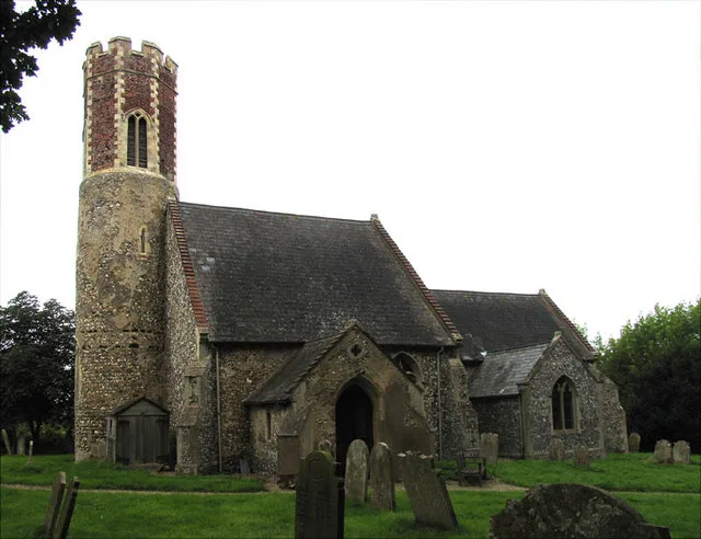
Hevingham — village and civil parish in Norfolk, UK.

Wikimedia Commons contributors — see linked file page for photographer and licence licence

Plan your visit
- Typical visit
- 3 h–6 h
- Nearest railway station
- Brampton · 3.2 km
- Free entry
- Family-friendly
- Dog-friendly
Getting there & planning your visit
Hevingham is located in the East Midlands, with the nearest railway station being Brampton, which is 3.2 km away. Entry to the town is free. The postcode for Hevingham is NR10, and the sat-nav coordinates are 52.7438 latitude and 1.2629 longitude.
About
Hevingham is a town, city, village or settlement in the United Kingdom. It covers approximately 12 km². Recent population estimates put it at around 1,150 people. Address: NR10. Wikidata describes it as: "village and civil parish in Norfolk, UK". Coordinates: 52.7438°, 1.2629°.
Photo gallery
Protected designations
- Area of Outstanding Natural Beauty: Norfolk Coast
Designations sourced from Natural England open data under OGL v3.
From the Wikipedia article
Hevingham is a village and civil parish in the Broadland district of the English county of Norfolk. The village is located between the A140 and the B1149. Hevingham is located 4 miles (6.4 km) south of Aylsham and 7 miles (11 km) north of Norwich.
Excerpt from Wikipedia under CC BY-SA 4.0. See the source article linked in Sources below.
Background
History
The village name has Old English origins and is translated as homestead of the people of Hefa. Archaeological evidence shows that the site of the village has been occupied since the Bronze Age. But there are much earlier signs of activity, a Mesolithic flint axe-head being the earliest archaeological find recorded, with several Neolithic flint axe-heads also being recovered. There is evidence of Roman activity. A Roman iron-working site was found during ploughing and was subsequently excavated. Archaeologists also investigated pottery kilns in the parish in the 1950s. Five kilns were recorded. These produced cooking vessels and other pottery during the 2nd century. The names of two potters…
Description
A sign of two crossed birch brooms which recalls a staple industry of the village in the past. The idea for the sign was conceived by a Mr. Wymer, one of the last of the brushmakers. The background imagery of the sign fits with the description given by Rev. Francis Blomfield when he wrote about the village in 1750, mentioning that "it lay at the confluence of several small streams". The sign is situated at the corner of the village green on Westgate (Formerly a pond called 'Westgate pit') and the current incarnation was erected in 2009.
Sourced from Wikipedia under CC BY-SA 4.0.
- Coordinates
- 52.7438, 1.2629
- County
- Norfolk
- District
- Broadland
- Parish
- Hevingham
- Postcode
- NR10
- Parliamentary constituency
- Broadland and Fakenham
- Population
- 1,150
- Nearest railway station
- Brampton — 3.2 km
Sources
- wikidata: Q1780233 (CC0)
- wikipedia: Hevingham (CC BY-SA 4.0)
- commons: St Botolph, Hevingham, Norfolk - geograph.org.uk - 317204.jpg (CC BY-SA 4.0)
Other places nearby

Hevingham
Villages · 0.5 km
Pound Farm
Caravan parks · 0.6 km

Hevingham Village Sign
Public art & sculpture · 1.0 km

Hevingham War Memorial
Memorials & monuments · 1.1 km

Cobbleacre Park Lakes
Campsites · 1.3 km

Stratton Strawless Village Sign
Public art & sculpture · 1.7 km

Marsham Mill Road Village Sign
Public art & sculpture · 2.1 km
Brampton
Towns & cities · 2.1 km

Hevingham Lakes
Campsites · 2.3 km

Pump Corner Village Sign
Public art & sculpture · 2.4 km

Marsham War Memorial
Memorials & monuments · 2.5 km

Marsham
Villages · 2.9 km
Hevingham is a village in Norfolk, located in the East Midlands, with a population of 1,150. Our guide lists N attractions within reach.
At a glance
- Population
- 1,150
- Administrative county
- Norfolk
- Constituency
- Broadland and Fakenham
- Top categories near here
Things to see in Hevingham
13 attractions within 12 km. Full guide: things to do in Hevingham →
 📷 3
📷 3Forests & woodlands · East of England
Buxton Heath
Buxton Heath is a forest or woodland in the United Kingdom.
📷 3Memorials & monuments · East of England
Hevingham War Memorial
Hevingham War Memorial — Grade II listed building-listed memorial in england-east-midlands, United Kingdom.
 📷 3
📷 3Memorials & monuments · East of England
Hainford War Memorial
Hainford War Memorial — Grade II listed building-listed memorial in england-east-midlands, United Kingdom.
 📷 3
📷 3Public art & sculpture · East of England
St.Faith / Newton Village Sign
St.Faith / Newton Village Sign — a public art in england-east-midlands, United Kingdom.
 📷 3
📷 3Public art & sculpture · East of England
Hainford Village Sign
Hainford Village Sign — a public art in england-east-midlands, United Kingdom.
📷 3Public art & sculpture · East of England
Hevingham Village Sign
Hevingham Village Sign — a public art in england-east-midlands, United Kingdom.
📷 3Public art & sculpture · East of England
Stratton Strawless Village Sign
Stratton Strawless Village Sign — a public art in england-east-midlands, United Kingdom.
📷 5Campsites · East of England
Cobbleacre Park Lakes
Cobbleacre Park Lakes — a campsite in england east midlands.
📷 5📷 5📷 5 📷 5
📷 5 📷 5
📷 5Archaeological sites · East of England
All Saints' Church
All Saints' Church — archaeological in england east midlands.
Nearby
📷 5📷 5📷 3Public art & sculpture · East of England
Hevingham Village Sign
Hevingham Village Sign — a public art in england-east-midlands, United Kingdom.
📷 3Memorials & monuments · East of England
Hevingham War Memorial
Hevingham War Memorial — Grade II listed building-listed memorial in england-east-midlands, United Kingdom.
📷 5Campsites · East of England
Cobbleacre Park Lakes
Cobbleacre Park Lakes — a campsite in england east midlands.
📷 3Public art & sculpture · East of England
Stratton Strawless Village Sign
Stratton Strawless Village Sign — a public art in england-east-midlands, United Kingdom.
Where to eat & stay near Hevingham
Places to stay
📷 5📷 5Campsites · East of England
Cobbleacre Park Lakes
Cobbleacre Park Lakes — a campsite in england east midlands.
📷 5 📷 5
📷 5 📷 5
📷 5Campsites · East of England
Moat Island Glamping
Moat Island Glamping — a campsite in england east midlands.
📷 5Caravan parks · East of England
Charmbeck Park
Charmbeck Park — a caravan park in england east midlands.
Places to eat & drink
 📷 5
📷 5 📷 7
📷 7Historic pubs · East of England
Recruiting Sergeant Inn
Recruiting Sergeant Inn in England East, United Kingdom.
 📷 5
📷 5Historic pubs · East of England
Buckinghamshire Arms Public House
Buckinghamshire Arms Public House in England East, United Kingdom.
 📷 5
📷 5 📷 5
📷 5Historic pubs · East of England
The Marlpit Public House
The Marlpit Public House in England East, United Kingdom.
 📷 5
📷 5Historic pubs · East of England
Gibraltar Gardens
Gibraltar Gardens in England East, United Kingdom.
More towns in this region
 Flagship📷 10
 Flagship📷 10
Towns & cities · East of England
Cambridge
Cambridge — city in Cambridgeshire, England.
 Flagship📷 10
Towns & cities · East of England
Chelmsford
Chelmsford — city in Essex, United Kingdom.
 Flagship📷 10
Towns & cities · East of England
Colney Heath
Colney Heath — village and civil parish in St Albans, Hertfordshire, England, UK.
Frequently asked questions
- Where is Hevingham?
- Hevingham is in Norfolk, the East Midlands, United Kingdom (postcode NR10), in the parish of Hevingham.
- What is Hevingham?
- Hevingham — village and civil parish in Norfolk, UK.
- How do I get to Hevingham?
- The nearest railway station is Brampton, about 3.2 km away. Drivers can use postcode NR10.
- Is Hevingham a protected site?
- Yes — Hevingham is part of the Norfolk Coast National Landscape (AONB).
- Is Hevingham free to visit?
- Yes, Hevingham is free to enter.
- How do I get to Hevingham?
- The nearest railway station is Brampton, about 3.2 km away. Drivers can navigate to postcode NR10.