
Archaeological sites · North East England
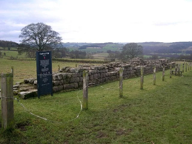
Hadrian's Wall and vallum between field boundary east of milecastle 24 and field boundary west of the site of turret 25b in wall miles 24-25
In or near Acomb.
Hadrian's Wall and vallum between field boundary east of milecastle 24 and field boundary west of the site of turret 25b in wall miles 24-25 — archaeological site in Wall, Northumberland, England, UK.

Mike Quinn — CC BY-SA 2.0 via Wikimedia Commons licence

Plan your visit
- Typical visit
- 45 min–1.5 h
- Nearest railway station
- Hexham · 5.1 km
- Free entry
- Dog-friendly
About
Hadrian's Wall and vallum between field boundary east of milecastle 24 and field boundary west of the site of turret 25b in wall miles 24-25 is an archaeological site in the United Kingdom. It covers approximately 32 km². Heritage designation: scheduled monument. Part of Hadrian's Wall. Wikidata describes it as: "archaeological site in Wall, Northumberland, England, UK". Coordinates: 55.0190°, -2.0830°.
Photo gallery
See it from the streetimagery from 2019
Imagery © Mapillary contributors, CC BY-SA 4.0
Place summary
Hadrian's Wall and vallum, located in the Scottish Lowlands within the parish of Wall, is an archaeological site designated as a scheduled monument. This section lies between the field boundary east of milecastle 24 and the field boundary west of turret 25b, spanning wall miles 24-25.
AI-generated from the structured facts on this page (operator, designation, listing, era). Not a substitute for visiting.
- Coordinates
- 55.0190, -2.0830
- District
- Northumberland
- Parish
- Wall
- Postcode
- NE46 4HD
- Parliamentary constituency
- Hexham
- Nearest railway station
- Hexham — 5.1 km
Sources
- wikidata: Q17650513 (CC0)
Other places nearby

Milecastle 25 (Codlawhill)
Archaeological sites · 0.2 km
Milecastle 25
Roman villas · 0.2 km

Battle of Heavenfield
Memorials & monuments · 1.1 km

Battle of Heavenfield (AD 635)
Forts · 1.2 km

Milecastle 24
Natural landmarks · 1.3 km
Milecastle 24 (Wall Fell)
Archaeological sites · 1.3 km

Medieval cross, 400m south east of Crag House
Historic houses · 1.5 km

Milecastle 26
Archaeological sites · 1.7 km
Planetrees
Hill forts · 1.9 km

Planetrees Roman Wall
Archaeological sites · 1.9 km

Cocklaw Tower
Historic houses · 2.0 km

Brunton Bank Quarry
Wildlife reserves · 2.0 km
Nearby
📷 3Archaeological sites · North East England
Milecastle 25 (Codlawhill)
Milecastle 25 (Codlawhill) — a archaeological in scotland-lowlands, United Kingdom.
📷 3📷 4Memorials & monuments · North East England
Battle of Heavenfield
Battle of Heavenfield — a memorial in scotland-lowlands, United Kingdom.
📷 3Forts · North East England
Battle of Heavenfield (AD 635)
Battle of Heavenfield (AD 635) is a fort in the United Kingdom.
📷 3Natural landmarks · North East England
Milecastle 24
Milecastle 24 in England North East, United Kingdom.
📷 3Archaeological sites · North East England
Milecastle 24 (Wall Fell)
Milecastle 24 (Wall Fell) — a archaeological in scotland-lowlands, United Kingdom.
Where to eat & stay near Hadrian's Wall and vallum between field boundary east of milecastle 24 and field boundary west of the site of turret 25b in wall miles 24-25
Places to stay
 📷 5
📷 5Campsites · North East England
Fallowfield Caravan Park
Fallowfield Caravan Park — a campsite in scotland lowlands.
 📷 7
📷 7Hotels · North East England
George Hotel
George Hotel — a hotel in scotland lowlands.
 📷 5
📷 5Caravan parks · North East England
Riverside Leisure Holiday Park
Riverside Leisure Holiday Park — a caravan park in scotland lowlands.
 📷 5
📷 5Caravan parks · North East England
Tyne Green Holiday Park
Tyne Green Holiday Park — a caravan park in scotland lowlands.
 📷 5
📷 5Caravan parks · North East England
Well House CAMC CL
Well House CAMC CL — a caravan park in scotland lowlands.
 📷 5
📷 5B&Bs · North East England
The Station Inn
The Station Inn — a bed-and-breakfast in scotland lowlands.
Places to eat & drink
 📷 6
📷 6 📷 5
📷 5 📷 7
📷 7Historic pubs · North East England
The Vicars Pele
The Vicars Pele in Scotland Lowlands, United Kingdom.
 📷 5
📷 5Historic pubs · North East England
Wellington Inn
Wellington Inn in Scotland Lowlands, United Kingdom.
 📷 5
📷 5Historic pubs · North East England
Travellers' Rest Inn
Travellers' Rest Inn in Scotland Lowlands, United Kingdom.
 📷 7
📷 7Historic pubs · North East England
Anchor Hotel
Anchor Hotel in Scotland Lowlands, United Kingdom.
More archaeological sites in this region
 📷 5
📷 5Archaeological sites · North East England
Medieval Manorial Site of Low Dinsdale
Medieval Manorial Site of Low Dinsdale — archaeological in england yorkshire.
 📷 3
📷 3Archaeological sites · North East England
Old Smelting Mill
Old Smelting Mill — a archaeological in england-north-west, United Kingdom.
 📷 5
📷 5Archaeological sites · North East England
Roper Castle or Round Table (Roman Signal Station)
Roper Castle or Round Table (Roman Signal Station) — archaeological in england north west.
 📷 5
📷 5Archaeological sites · North East England
Nine Standards Rigg
Nine Standards Rigg — archaeological in england north west. Elevation: 662 m.
Frequently asked questions
- Where is Hadrian's Wall and vallum between field boundary east of milecastle 24 and field boundary west of the site of turret 25b in wall miles 24-25?
- Hadrian's Wall and vallum between field boundary east of milecastle 24 and field boundary west of the site of turret 25b in wall miles 24-25 is in the Scottish Lowlands, United Kingdom (postcode NE46 4HD), in the parish of Wall.
- What is Hadrian's Wall and vallum between field boundary east of milecastle 24 and field boundary west of the site of turret 25b in wall miles 24-25?
- Hadrian's Wall and vallum between field boundary east of milecastle 24 and field boundary west of the site of turret 25b in wall miles 24-25 — archaeological site in Wall, Northumberland, England, UK.
- How do I get to Hadrian's Wall and vallum between field boundary east of milecastle 24 and field boundary west of the site of turret 25b in wall miles 24-25?
- The nearest railway station is Hexham, about 5.1 km away. Drivers can use postcode NE46 4HD.
- Is Hadrian's Wall and vallum between field boundary east of milecastle 24 and field boundary west of the site of turret 25b in wall miles 24-25 a listed building?
- Hadrian's Wall and vallum between field boundary east of milecastle 24 and field boundary west of the site of turret 25b in wall miles 24-25 is officially recognised as scheduled monument listed.
- Is Hadrian's Wall and vallum between field boundary east of milecastle 24 and field boundary west of the site of turret 25b in wall miles 24-25 free to visit?
- Yes, Hadrian's Wall and vallum between field boundary east of milecastle 24 and field boundary west of the site of turret 25b in wall miles 24-25 is free to enter.
- How do I get to Hadrian's Wall and vallum between field boundary east of milecastle 24 and field boundary west of the site of turret 25b in wall miles 24-25?
- The nearest railway station is Hexham, about 5.1 km away. Drivers can navigate to postcode NE46 4HD.