Mountains & hills · North West England
Gragareth
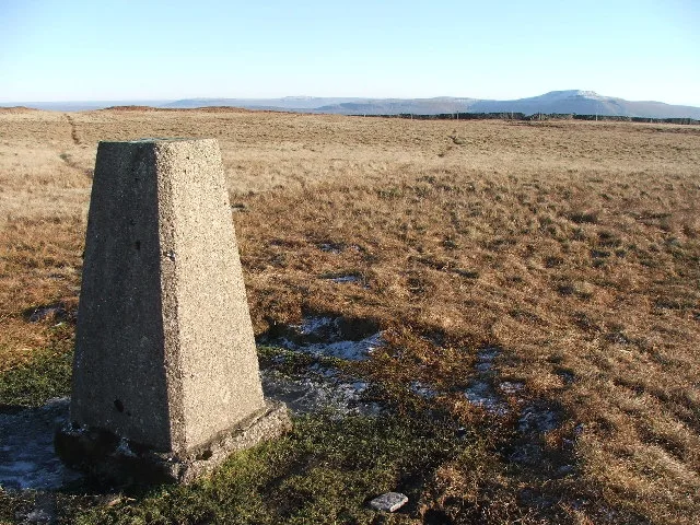
Gragareth — Named summit at 627 m.

Wikimedia Commons contributors — see linked file page for photographer and licence licence
Plan your visit
- Typical visit
- 3 h–8 h
- Best time of year
- Late spring – early autumn (May–Oct)
- Nearest railway station
- Ribblehead · 7.8 km
- Free entry
- Dog-friendly
About
Gragareth is a named summit in the United Kingdom. Wikidata describes it as: "Named summit at 627 m.". Coordinates: 54.2087°, -2.4801°.
Photo gallery
Protected designations
- Site of Special Scientific Interest: Whernside SSSI
Designations sourced from Natural England open data under OGL v3.
From the Wikipedia article
Gragareth is a mountain straddling the border between Lancashire and North Yorkshire in England. At 627 metres (2,057 ft), its summit is the second-highest point in the post-1974 county of Lancashire. The highest point in modern Lancashire is Green Hill (one metre higher), approximately 3.2 km (2.0 mi) to the north and the Old Man of Coniston in the Furness Fells of the Lake District at 803 metres (2,635 ft) is the county top of the traditional county of Lancashire. The summit of Gragareth lies about 200 m west of the county boundary, but inside the 2016 border of Yorkshire Dales National Park. The western slopes are known as Leck Fell and the southern slopes form Ireby Fell. The summit has a trig point and extensive views towards Morecambe Bay, the Lake District fells, the Howgill Fells, Ingleborough and the Forest of Bowland. The county boundary wall running along the ridge is believed to be "one of the highest dry stone walls in the country." The Three Men of Gragareth are a group of tall cairns on the western side of the hill above Leck Fell House. Historically the hill was often called Greygarth Fell. The fell contains several caves including Lost John's Cave, Rumbling Hole and Ireby Fell Cavern. Wainwright includes "The ascent of Gragareth via Leck Fell returning via Ireby Fell" in his Walks in Limestone Country. His route begins at Ireby village, following a lane from Todgill Farm on the Leck road to the tarmac road which leads to Leck Fell House, then "a steep scramble" up past the Three Men. His descent route is down a long enclosure formed by the county boundary to the east and the almost-parallel boundary between Leck and Ireby parishes, dropping down Ireby Fell past the opening of Ireby Fell Cavern, to return to Ireby.
Excerpt from Wikipedia under CC BY-SA 4.0. See the source article linked in Sources below.
- Coordinates
- 54.2087, -2.4801
- Address
- Chichester |publisher= Summersdale |isbn= 978-1-84-953239-6 |pages= 224–233}}</ref>
- Nearest railway station
- Ribblehead — 7.8 km
Sources
- osm: n31361602 (ODbL)
- wikipedia: Gragareth (CC BY-SA 4.0)
- commons: Gragareth trig point.jpg (CC BY-SA 4.0)
Other places nearby
Loading nearby places…
Nearby
 📷 5
📷 5Natural landmarks · North West England
Gragareth
Gragareth — mountain in Lancashire, United Kingdom.
 📷 3
📷 3Memorials & monuments · North West England
Three Men of Gragareth
Three Men of Gragareth is a memorial in the United Kingdom.
 📷 3
📷 3Historic houses · North West England
Shepherds hut
Shepherds hut — a historic house in england-north-west, United Kingdom.
 📷 3
📷 3Caves · North West England
Jingling Pot
Jingling Pot is a cave in the United Kingdom.
 📷 3
📷 3Caves · North West England
Aquamole Pot
Aquamole Pot is a cave in the United Kingdom.
 📷 5
📷 5Caves · North West England
Bull Pot
Bull Pot — cave in england north west.
More mountains in this region
 📷 3
📷 3Mountains & hills · North West England
Allen Crags
Allen Crags — Named summit at 785 m.
 📷 3
📷 3Mountains & hills · North West England
Alum Pot
Alum Pot — Open shaft pothole in North Yorkshire.
 📷 3
📷 3Mountains & hills · North West England
Arnside Knott
Arnside Knott — Named summit at 159 m.
 📷 3
📷 3Mountains & hills · North West England
Aye Gill Pike
Aye Gill Pike — Named summit at 556.3 m.
Frequently asked questions
- Where is Gragareth?
- Gragareth is in North-West England, United Kingdom.
- What is Gragareth?
- Gragareth — Named summit at 627 m.
- How do I get to Gragareth?
- The nearest railway station is Ribblehead, about 7.8 km away. Its coordinates are 54.2087°, -2.4801°.
- Is Gragareth a protected site?
- Yes — Gragareth is part of the Whernside SSSI Site of Special Scientific Interest.
- Is Gragareth free to visit?
- Yes, Gragareth is free to enter.
- How do I get to Gragareth?
- The nearest railway station is Ribblehead, about 7.8 km away.