Mountains & hills · North East England
Gowbarrow Fell Summit
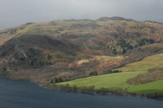
Gowbarrow Fell Summit — mountain in england north east. Elevation: 481.2 m.

Michael Graham — CC BY-SA 2.0 via Wikimedia Commons licence
Plan your visit
- Typical visit
- 3 h–8 h
- Best time of year
- Late spring – early autumn (May–Oct)
About
Gowbarrow Fell Summit is a mountain located in england north east. Elevation: 481.2 m. A named British peak recorded in OpenStreetMap. Peaks are typically named on Ordnance Survey 1:50k mapping.
Photo gallery
Place summary
Gowbarrow Fell Summit is a mountain located in North-East England. It is part of the Eastern Fells of the Lake District National Park. The summit offers panoramic views over Ullswater and the surrounding landscape. It is a popular destination for walkers and hikers seeking a challenging ascent and scenic vistas.
AI-generated from the structured facts on this page (operator, designation, listing, era). Not a substitute for visiting.
- Coordinates
- 54.5872, -2.9187
Sources
- osm: n11192972479 (ODbL)
Other places nearby
Loading nearby places…
Nearby
 📷 4
📷 4Mountains & hills · North East England
Gowbarrow Fell (Wainwright)
Gowbarrow Fell (Wainwright) — Named summit at 481.1 m.
 📷 4
📷 4Natural landmarks · North East England
Gowbarrow Fell
Gowbarrow Fell — mountain in Cumbria, United Kingdom.
 📷 5
📷 5Mountains & hills · North East England
Gowbarrow Park
Gowbarrow Park — mountain in england north east. Elevation: 464 m.
 📷 3
📷 3Public art & sculpture · North East England
Herdwick Stone - Yan
Herdwick Stone - Yan — a public art in england-north-east, United Kingdom.
 📷 5
📷 5Mountains & hills · North East England
Green Hill
Green Hill — mountain in england north east. Elevation: 439 m.
 📷 5
📷 5Mountains & hills · North East England
Great Meldrum
Great Meldrum — mountain in england north east. Elevation: 437 m.
Where to eat & stay near Gowbarrow Fell Summit
Places to stay

Caravan parks · North East England
Knotts Hill Lodge Park
Knotts Hill Lodge Park — a caravan park in england north east.
 📷 5
📷 5Caravan parks · Scottish Lowlands
Cove Park
Cove Park — a caravan park in scotland lowlands.
📷 5Caravan parks · Scottish Lowlands
The Quiet Site
The Quiet Site — a caravan park in scotland lowlands.
 📷 5
📷 5Campsites · North East England
Ullswater Holiday Park
Ullswater Holiday Park — a campsite in england north east.
 📷 5
📷 5Caravan parks · Scottish Lowlands
Troutbeck Head (Caravan & Motorhome Club)
Troutbeck Head (Caravan & Motorhome Club) — a caravan park in scotland lowlands.
 📷 5
📷 5Campsites · North East England
Side Farm Campsite
Side Farm Campsite — a campsite in england north east.
Places to eat & drink
 📷 5
📷 5Cafés · Scottish Lowlands
Narrowbar Cafe
Narrowbar Cafe — a café in scotland lowlands.
 📷 5
📷 5Cafés · Scottish Lowlands
YHA Cafe
YHA Cafe — a café in scotland lowlands.
 📷 5
📷 5Cafés · North East England
Grange Bridge Cottage
Grange Bridge Cottage — a café in england north east.
 📷 4
📷 4Restaurants · North West England
Holbeck Ghyll
Holbeck Ghyll is a restaurant located in Windermere, Cumbria, England. "The late 19th century building was once Lord Lonsdale's hunting lodge and only became a hotel in the 1970s. It won a Michelin st
 📷 5
📷 5Restaurants · North West England
Holbeck Ghyll Restaurant
Holbeck Ghyll Restaurant — a restaurant in england north west.
 📷 4
📷 4Historic pubs · Scottish Lowlands
Oddfellows Arms
Oddfellows Arms — Historic pub — listed building or notable heritage status.
More mountains in this region
 📷 3
📷 3Mountains & hills · North East England
Angletarn Pikes
Angletarn Pikes — Named summit at 566 m.
 📷 3
📷 3Mountains & hills · North East England
Angletarn Pikes South Top
Angletarn Pikes South Top — Named summit at 563.6 m.
 📷 3
📷 3Mountains & hills · North East England
Ard Crags
Ard Crags — Named summit at 581 m.
 📷 3
📷 3Mountains & hills · North East England
Arnison Crag
Arnison Crag — Named summit at 433 m.
Frequently asked questions
- Where is Gowbarrow Fell Summit?
- Gowbarrow Fell Summit is in North-East England, United Kingdom.
- What is Gowbarrow Fell Summit?
- Gowbarrow Fell Summit — mountain in england north east. Elevation: 481.2 m.
- How do I get to Gowbarrow Fell Summit?
- Its coordinates are 54.5872°, -2.9187°.