
Mountains & hills · Scottish Islands
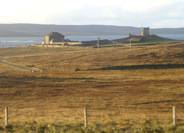
Gillis Field
Gillis Field — a hill or mountain in scotland islands.

Mike Pennington — CC BY-SA 2.0 via Wikimedia Commons licence

Plan your visit
- Typical visit
- 3 h–8 h
- Best time of year
- Late spring – early autumn (May–Oct)
- Dog-friendly
About
A British hill or mountain, named on Ordnance Survey maps and walked by hill-baggers. Gillis Field is a named hill or mountain in scotland islands, recorded in the GeoNames UK gazetteer. British landmarks of this type are typically marked on Ordnance Survey maps and recorded in the national gazetteer for cartographic and navigational reference. Coordinates and feature classification are sourced from the GeoNames open dataset.
Photo gallery
Place summary
Gillis Field is a mountain located in the Scottish Islands. It offers a rugged landscape typical of the region, characterised by its natural beauty and challenging terrain. Visitors can expect a range of outdoor activities, including hiking and climbing, amidst scenic views. The area is suitable for experienced adventurers and those seeking solitude in a remote setting.
AI-generated from the structured facts on this page (operator, designation, listing, era). Not a substitute for visiting.
- Coordinates
- 60.5762, -0.8776
Sources
- manual: geonames-12611737 (CC BY 4.0)
Other places nearby
Gillis Field
Mountains & hills · 0.0 km

Wick of Tresta
Natural landmarks · 1.0 km

Ruir Taing, promontory fort
Archaeological sites · 1.2 km
Lamb Hoga Broch
Archaeological sites · 1.3 km

Ruir Taing, Lamb Hoga, Fetlar
Vineyards · 1.3 km

Wick of Houbie Broch
Archaeological sites · 1.8 km

Wick of Houbie Broch
Archaeological sites · 1.8 km

Fetlar Church
Historic churches · 2.1 km

Fetlar Interpretive Centre
Museums · 2.2 km
Fetlar
Islands · 2.7 km

Aithbank, Winna Tonga, Fetlar
Vineyards · 2.8 km

Winna Tonga, promontory fort
Archaeological sites · 2.8 km
Nearby
📷 4Mountains & hills · Scottish Islands
Gillis Field
Gillis Field — mountain in scotland islands. Elevation: 115 m.
📷 5Natural landmarks · Scottish Islands
Wick of Tresta
Wick of Tresta — a natural feature in scotland islands.
📷 5Archaeological sites · Scottish Islands
Ruir Taing, promontory fort
Ruir Taing, promontory fort — a archaeological in scotland-islands, United Kingdom.
📷 5Archaeological sites · Scottish Islands
Lamb Hoga Broch
Lamb Hoga Broch — a archaeological in scotland-islands, United Kingdom.
📷 5Vineyards · Scottish Islands
Ruir Taing, Lamb Hoga, Fetlar
Ruir Taing, Lamb Hoga, Fetlar — a UK vineyard in scotland islands, producing English or Welsh wine from cool-climate grape varieties.
📷 3Archaeological sites · Scottish Islands
Wick of Houbie Broch
Wick of Houbie Broch — a archaeological in scotland-islands, United Kingdom.
Where to eat & stay near Gillis Field
Places to stay
📷 5Hostels · Scottish Islands
Aithbank Camping Böd
Aithbank Camping Böd — a hostel in scotland islands.
 📷 5
📷 5Campsites · Scottish Islands
Burravoe Pier Trust Campsite
Burravoe Pier Trust Campsite — a campsite in scotland islands.
 📷 5
📷 5Caravan parks · Scottish Islands
Gardiesfauld Caravan Park
Gardiesfauld Caravan Park — a caravan park in scotland islands.
 📷 5
📷 5Campsites · Scottish Islands
Gardiesfauld Campsite
Gardiesfauld Campsite — a campsite in scotland islands.
 📷 5
📷 5 📷 5
📷 5More mountains in this region
 📷 3
📷 3Mountains & hills · Scottish Islands
Acairseid Mhor
Acairseid Mhor — bay in Outer Hebrides, Scotland, UK.
 📷 3
📷 3Mountains & hills · Scottish Islands
Ainshval
Ainshval — Named summit at 781 m.
 📷 3
📷 3 📷 5
📷 5Mountains & hills · Scottish Islands
An Cliseam
An Cliseam — Named summit at 799 m.
Frequently asked questions
- Where is Gillis Field?
- Gillis Field is in the Scottish Islands, United Kingdom.
- What is Gillis Field?
- Gillis Field — a hill or mountain in scotland islands.
- How do I get to Gillis Field?
- Its coordinates are 60.5762°, -0.8776°.