
Towns & cities · Northern Ireland
Dunloy
Also known as: Dún Lathaí
Dunloy — village in County Antrim, Northern Ireland, UK.

Wikimedia Commons contributors — see linked file page for photographer and licence licence

Plan your visit
- Typical visit
- 3 h–6 h
- Nearest railway station
- Ballymoney · 9.6 km
- Free entry
- Family-friendly
- Dog-friendly
About
Dunloy is a town, city, village or settlement in the United Kingdom. Recent population estimates put it at around 1,194 people. Wikidata describes it as: "village in County Antrim, Northern Ireland, UK". Coordinates: 55.0000°, -6.4167°.
Photo gallery
From the Wikipedia article
Dunloy (from Irish Dún Lathaí, meaning 'fort of the muddy place or marsh') is a village and townland in County Antrim, Northern Ireland. It is located 11 miles (18 km) north of Ballymena and 6 miles (10 km) north-west is Ballymoney. It is located in the civil parish of Finvoy, in the former barony of Kilconway. The village had a population of 1,150 people in the 2021 Census.
Excerpt from Wikipedia under CC BY-SA 4.0. See the source article linked in Sources below.
Background
History
Dunloy lies in the ancient Irish district of "Killimorrie", which is now known as Killymurris. Killymurris is claimed as being derived from the Irish Coill Ui Mhuireadhaigh meaning "the wood of Murry". Just south of Dunloy village, in the townland of Ballymacaldrack is "Dooey's Cairn". This open court tomb, named after the landowner, is located on the slopes of Long Mountain and overlooks the valley of the River Main. The earliest known activity within the tomb is estimated at around 4000BC. Also on Long Mountain is another court Tomb, known as Broadstone. See: List of megalithic monuments in Ireland In the same townland lies the ancient graveyard of Caldernagh.
Description
On 11 July 1978, John Boyle, a 16-year-old civilian, was shot dead by SAS soldiers in a graveyard in the village. The previous day he had discovered an IRA arms cache under a fallen tombstone when he was visiting a family grave and reported the weapons to his father. His father then contacted the Royal Ulster Constabulary who, rather than removing the weapons, passed the information to the British Army, who placed SAS operatives at the site. The next day, Boyle returned to the graveyard (presumably out of curiosity to see if the weapons were still there). He was then shot dead by the British soldiers, who alleged he picked up a rifle and aimed it towards them; however a leaked RUC document…
Sourced from Wikipedia under CC BY-SA 4.0.
- Coordinates
- 55.0000, -6.4167
- District
- Causeway Coast and Glens
- Postcode
- BT44 9EH
- Parliamentary constituency
- North Antrim
- Population
- 1,194
- Nearest railway station
- Ballymoney — 9.6 km
Sources
- wikidata: Q1752141 (CC0)
- wikipedia: Dunloy (CC BY-SA 4.0)
- commons: Main Street Dunloy - geograph.org.uk - 825874.jpg (CC BY-SA 4.0)
Other places nearby

Long Mountain
Mountains & hills · 0.8 km
Long Mountain
Mountains & hills · 0.8 km
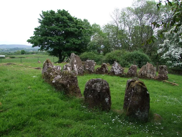
Dooey's Cairn
Hill forts · 0.8 km

Dunloy
Villages · 1.3 km

Dunloy railway station
Natural landmarks · 1.9 km

Anticur
Natural landmarks · 2.5 km

Craigs Upper
Villages · 3.2 km

The Broad Stone (Craigs)
Archaeological sites · 3.5 km

Killagan railway station
Natural landmarks · 3.5 km

Craigs Middle
Villages · 3.7 km
Craigs Lower
Villages · 3.7 km
Craigs
Villages · 3.7 km
Dunloy is a village located in Northern Ireland with a population of 1,194. Our guide lists several nearby attractions within reach.
At a glance
- Population
- 1,194
- Constituency
- North Antrim
- Top categories near here
Things to see in Dunloy
15 attractions within 12 km. Full guide: things to do in Dunloy →
📷 2Hill forts · Northern Ireland
Dooey's Cairn
Dooey's Cairn — archaeological site in County Antrim, Northern Ireland.
 📷 5
📷 5Burial mounds & barrows · Northern Ireland
Craigs Dolmen
Craigs Dolmen in Northern Ireland, United Kingdom.
 📷 3📷 4
Natural landmarks · Northern Ireland
Dunloy railway station
Dunloy railway station in Northern Ireland, United Kingdom.
 📷 2
📷 2Natural landmarks · Northern Ireland
Artiferrall
Artiferrall in Northern Ireland, United Kingdom.
 📷 4
📷 4Natural landmarks · Northern Ireland
Glarryford railway station
Glarryford railway station in Northern Ireland, United Kingdom.
📷 3Natural landmarks · Northern Ireland
Killagan railway station
Killagan railway station in Northern Ireland, United Kingdom.
 📷 3
📷 3Archaeological sites · Northern Ireland
Duneany Motte
Duneany Motte — a archaeological in northern-ireland, United Kingdom.
Archaeological sites · Northern Ireland
The Broad Stone (Craigs)
The Broad Stone (Craigs) — a archaeological in northern-ireland, United Kingdom.
 📷 5📷 5📷 5📷 5
Mountains & hills · Northern Ireland
Long Mountain
Long Mountain — a hill or mountain in northern ireland.
📷 5Mountains & hills · Northern Ireland
Long Mountain
Long Mountain — mountain in northern ireland. Elevation: 215.00 m.
Nearby
📷 5Mountains & hills · Northern Ireland
Long Mountain
Long Mountain — mountain in northern ireland. Elevation: 215.00 m.
📷 5Mountains & hills · Northern Ireland
Long Mountain
Long Mountain — a hill or mountain in northern ireland.
📷 2Hill forts · Northern Ireland
Dooey's Cairn
Dooey's Cairn — archaeological site in County Antrim, Northern Ireland.
📷 5📷 4Natural landmarks · Northern Ireland
Dunloy railway station
Dunloy railway station in Northern Ireland, United Kingdom.
Where to eat & stay near Dunloy
Places to stay
 📷 5
📷 5 📷 5
📷 5 📷 2
📷 2Caravan parks · Northern Ireland
Charlie's Hideaway Camping & Caravanning
Charlie's Hideaway Camping & Caravanning — a caravan park in northern ireland.
 📷 3
📷 3 📷 4
📷 4 📷 2
📷 2Caravan parks · Northern Ireland
Tullans Farm Caravan Park
Tullans Farm Caravan Park — a caravan park in northern ireland.
Places to eat & drink
 📷 5
📷 5 📷 7
📷 7Historic pubs · Northern Ireland
House of McDonnell
House of McDonnell in Northern Ireland, United Kingdom.
More towns in this region
 Flagship📷 5
Towns & cities · Northern Ireland
Bangor
Bangor — city in Northern Ireland, United Kingdom.
 Flagship📷 5
Towns & cities · Northern Ireland
Belfast
Belfast — capital city of Northern Ireland.
 Flagship📷 3
 Flagship📷 5
Towns & cities · Northern Ireland
Lisburn
Lisburn — city in Northern Ireland.
Frequently asked questions
- Where is Dunloy?
- Dunloy is in Northern Ireland, United Kingdom (postcode BT44 9EH).
- What is Dunloy?
- Dunloy — village in County Antrim, Northern Ireland, UK.
- How do I get to Dunloy?
- The nearest railway station is Ballymoney, about 9.6 km away. Drivers can use postcode BT44 9EH.
- Is Dunloy free to visit?
- Yes, Dunloy is free to enter.
- How do I get to Dunloy?
- Drivers can navigate to postcode BT44 9EH. It sits within the North Antrim parliamentary constituency.