
Natural landmarks · Central Scotland
Dumyat
In or near Blairlogie.
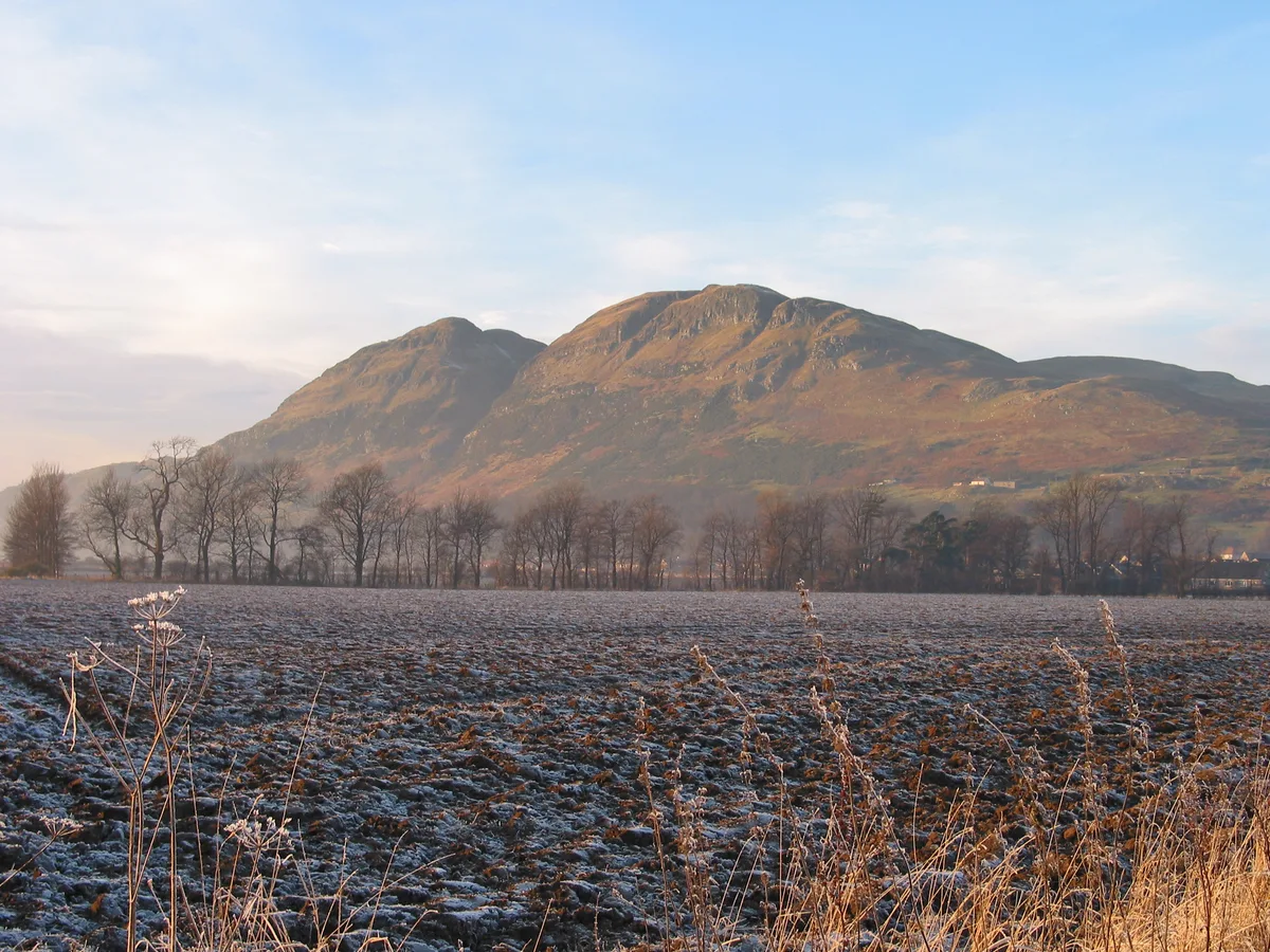
Dumyat — mountain in Stirling, Scotland, UK.

Wikimedia Commons contributors — see linked file page for photographer and licence licence

Plan your visit
- Typical visit
- 1 h–2 h
- Nearest railway station
- Bridge of Allan · 5.0 km
- Free entry
- Dog-friendly
Getting there & planning your visit
To visit Dumyat, the nearest railway station is Bridge of Allan, located 5 km away. The postcode for navigation is FK9 5QE, and entry to the site is free.
About
Dumyat is a named natural landmark in the United Kingdom. Wikidata describes it as: "mountain in Stirling, Scotland, UK". Coordinates: 56.1577°, -3.8773°.
Photo gallery
From the Wikipedia article
Dumyat or Dunmyat (Scottish Gaelic: Dùn Mhèad) is a hill at the western extremity of the Ochil Hills in central Scotland. The name is thought to originate from Dun (hill fort) of the Maeatae. Although relatively small (its height is 418 metres), the characteristic shape of the hill forms an important part of the distinctive scenery of the Stirling area, and it is often depicted (particularly in postcards and calendars) in combination with the nearby Abbey Craig. The hill is a popular climb with tourists and visitors to the Stirling and Trossachs area, due to the historical nature of Stirling and the proximity of the Wallace Monument. Dumyat has two principal summits: Castle Law on the west, and Dumyat proper on the east. On the summit of Castle Law the remains of an ancient hill fort, originally occupied by the Maeatae, are still clearly discernible. The fort is a scheduled monument. The fort has been subject to excavation by Dr Murray Cook and Professor Gordon Noble of Aberdeen University. Radiocarbon dates from the site indicate at least two periods of use: c. 500 BC and 5th to 5th to 7th century AD. At one time the favourite route to the summit of either Dumyat or Castle Law was via the prominent gulley which runs almost straight up the southern scarp face, and continues down the gently sloping north face. This gulley was formed by the erosion of a fault, resulting from the juxtaposition of soft pyroclastic rocks on one side against harder andesite and basalt on the other. This has resulted in an area where hard andesite slightly overhangs, and is the darkest and least exposed part of the climb, which is not particularly difficult. Further gullies, formed by secondary tearing around the main fault (itself a product of the major disturbance which resulted from the Ochil Fault) extend to the right into Dumyat, and form potential shortcuts to the summit. The first of these, Raeburn's Gulley, is particularly dangerous and should only be attempted by experienced and…
Excerpt from Wikipedia under CC BY-SA 4.0. See the source article linked in Sources below.
- Coordinates
- 56.1577, -3.8773
- District
- Clackmannanshire
- Postcode
- FK9 5QE
- Parliamentary constituency
- Alloa and Grangemouth
- Nearest railway station
- Bridge of Allan — 5 km
Sources
- wikidata: Q1265168 (CC0)
- wikipedia: Dumyat (CC BY-SA 4.0)
- commons: Dumyat south elev.jpg (CC BY-SA 4.0)
Other places nearby

Argyll and Sutherland Highlanders Memorial Badge
Memorials & monuments · 0.1 km
Dumyat
Mountains & hills · 0.1 km

Castle Law
Mountains & hills · 0.4 km
Dumyat
Vineyards · 0.4 km

Blairlogie Castle
Castles · 1.0 km

Blairlogie
Towns & cities · 1.1 km
United Free Church, Blairlogie
Historic churches · 1.1 km

Menstrie Glen
Natural landmarks · 1.3 km

Old Bridge, Ochil Road, Menstrie
Historic bridges · 1.6 km
Menstrie War Memorial
Memorials & monuments · 1.6 km
Fox Boy
Public art & sculpture · 1.6 km
Menstrie
Other places · 1.6 km
Nearby
📷 3Memorials & monuments · Central Scotland
Argyll and Sutherland Highlanders Memorial Badge
Argyll and Sutherland Highlanders Memorial Badge — a memorial in scotland-central, United Kingdom.
📷 3📷 5Mountains & hills · Central Scotland
Castle Law
Castle Law — mountain in scotland central. Elevation: 374 m.
📷 5Vineyards · Central Scotland
Dumyat
Dumyat — a UK vineyard in scotland central, producing English or Welsh wine from cool-climate grape varieties.
📷 4📷 5Where to eat & stay near Dumyat
Places to stay
 📷 5
📷 5Campsites · Central Scotland
Witches Craig Caravan and Camping Park
Witches Craig Caravan and Camping Park — a campsite in scotland central.
 📷 5
📷 5Hotels · Central Scotland
Stirling Court Hotel
Stirling Court Hotel — a hotel in scotland central.
 📷 5
📷 5Hotels · Central Scotland
Dunmar House Hotel
Dunmar House Hotel — a hotel in scotland central.
 📷 5
📷 5Hostels · Central Scotland
William Wallace Hotel
William Wallace Hotel — a hostel in scotland central.
 📷 5
📷 5Hostels · Central Scotland
Stirling Youth Hostel
Stirling Youth Hostel — a hostel in scotland central.
 📷 6
📷 6Hotels · Central Scotland
DoubleTree by Hilton Hotel Dunblane Hydro
DoubleTree by Hilton Hotel Dunblane Hydro — a hotel in scotland central. 4-star. Brand: DoubleTree.
Places to eat & drink
 📷 6
📷 6Historic pubs · Central Scotland
Westerton Arms, 34 Henderson Street, Bridge of Allan
Westerton Arms, 34 Henderson Street, Bridge of Allan in Scotland Central, United Kingdom.
 📷 7
📷 7Historic pubs · Central Scotland
Johnstone Arms Hotel, 48 Stirling Street, Alva
Johnstone Arms Hotel, 48 Stirling Street, Alva in Scotland Central, United Kingdom.
 📷 6
📷 6Historic pubs · Central Scotland
The Gothenburg
The Gothenburg in Scotland Islands, United Kingdom.
 📷 7
📷 7Historic pubs · Central Scotland
Ye Olde House Inn, 25-26 Forth Street, Kincardine On Forth
Ye Olde House Inn, 25-26 Forth Street, Kincardine On Forth in Scotland Central, United Kingdom.
 📷 5
📷 5Historic pubs · Central Scotland
Dennyloanhead
Dennyloanhead in Scotland Islands, United Kingdom.
 📷 7
📷 7Historic pubs · Central Scotland
Red Lion Inn, Low Causeway, Culross
Red Lion Inn, Low Causeway, Culross in Scotland Central, United Kingdom.
More natural landmarks in this region
 📷 4
📷 4Natural landmarks · Central Scotland
Blackadder Water
Blackadder Water in England North East, United Kingdom.
 📷 3
📷 3Natural landmarks · Central Scotland
A6105 road
A6105 road in England North East, United Kingdom.
 📷 3
📷 3 📷 3
📷 3Frequently asked questions
- Where is Dumyat?
- Dumyat is in central Scotland, United Kingdom (postcode FK9 5QE).
- What is Dumyat?
- Dumyat — mountain in Stirling, Scotland, UK.
- How do I get to Dumyat?
- The nearest railway station is Bridge of Allan, about 5.0 km away. The nearest town is Blairlogie. Drivers can use postcode FK9 5QE.
- Is Dumyat free to visit?
- Yes, Dumyat is free to enter.
- How do I get to Dumyat?
- The nearest railway station is Bridge of Allan, about 5.0 km away. Drivers can navigate to postcode FK9 5QE.