
Historic churches · North West England
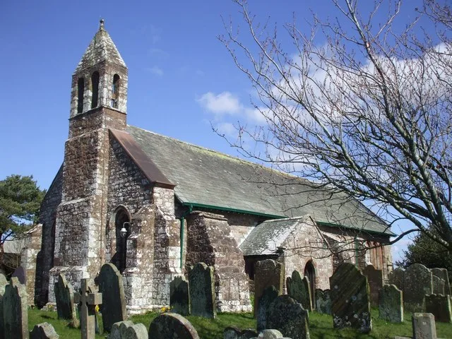
Dornock Parish Church
In or near Eastriggs.
Dornock Parish Church — category B listed building-listed church in scotland-lowlands, United Kingdom.

Chris Newman — CC BY-SA 2.0 via Wikimedia Commons licence

Plan your visit
- Typical visit
- 30 min–1 h
- Nearest railway station
- Annan · 3.8 km
- Free entry
Getting there & planning your visit
Dornock Parish Church is located in the Scottish Lowlands, with the nearest railway station being Annan, approximately 3.8 km away. The postcode for the church is DG12 6SU, and entry is free.
About
Dornock Parish Church is a category B listed building-listed church in scotland-lowlands, United Kingdom, registered on the Historic Environment Scotland register (entry LB3786). Listed status protects buildings and structures of special architectural or historic interest. See the linked Wikipedia article for further details.
Photo gallery
Heritage listing
Category B Date Added 03/08/1971 Local Authority Dumfries And Galloway Planning Authority Dumfries And Galloway Parish Dornock NGR NY 23048 65984 Coordinates 323048, 565984 — Built 1793. Straightforward T-plan church with round-headed openings and 4-bay long S elevation; low vestry adjoins E gable; N porch added 1861 with unusual roof. Rubble-built with ashlar dressings, polished margins, impost blocks and keystones. Blind oculus in N gable and birdcage belfry; other main gables capped with ball-finialled blocks. Margined glazing perhaps 1861; straight skews; slate roofs. Interior: refurbished and re-seated by James Barbour 1884-5; panelled octagonal pulpit centre on S wall with pilastered (?original) backboard; gallery in jamb opposite - installed 1861 - has similarly detailed panelled front. Circa 1900 painted and leaded glass windows flank pulpit. Churchyard: important group of 3 13th century coped grave stones close to E boundary: the northernmost is earthfast and badly weathered; other 2 richly carved and supported on four small Romanesque capitals dating to the late 11th or early 12th century. Numerous good 17th -19th century headstones. Random rubble boundary walls; 2 gateways in E wall with square corniced gatepiers, those nearest N dated 1902 with wrought-iron gates. — Ecclesiastical building in use as such. A good late 18th century T-plan church with handsome Victorian interior. A grass-grown mound in the churchyard, covered by later graves represents the site of E end of the medieval church. The 13th century carved stones are of national importance.
From Historic Environment Scotland under OGL v3.
Protected designations
- Site of Special Scientific Interest: Upper Solway Flats & Marshes SSSI
- Area of Outstanding Natural Beauty: Solway Coast
- Ramsar wetland: Upper Solway Flats & Marshes
Designations sourced from Natural England open data under OGL v3.
Place summary
Dornock Parish Church is located in the Scottish Lowlands. It is a category B listed building, recognised for its architectural and historical significance.
AI-generated from the structured facts on this page (operator, designation, listing, era). Not a substitute for visiting.
- Coordinates
- 54.9825, -3.2040
- District
- Dumfries and Galloway
- Postcode
- DG12 6SU
- Parliamentary constituency
- Dumfriesshire, Clydesdale and Tweeddale
- Nearest railway station
- Annan — 3.8 km
Sources
- wikidata: Q17792549 (CC0)
Other places nearby

Dornock
Villages · 0.3 km

Dornock Mains
Vineyards · 0.6 km

enclosure 270m W of Burnbrae
Vineyards · 0.8 km

St John's Episcopal Church, Ladysmith Road, Eastriggs
Historic churches · 1.5 km

Eastriggs
Towns & cities · 1.8 km

0-6-0 Fireless Loco 'Sir James'
Natural landmarks · 2.2 km

Animals in War Memorial
Memorials & monuments · 2.2 km

The Devil's Porridge Museum
Museums · 2.2 km

Bowness-on-Solway Roman Fort
Archaeological sites · 3.4 km
St Michael's Church
Historic churches · 3.4 km

Bowness on Solway War Memorial
Memorials & monuments · 3.4 km
Maia Roman Fort
Hill forts · 3.4 km
Nearby
📷 5📷 5Vineyards · North West England
Dornock Mains
Dornock Mains — a UK vineyard in scotland lowlands, producing English or Welsh wine from cool-climate grape varieties.
📷 5Vineyards · North West England
enclosure 270m W of Burnbrae
enclosure 270m W of Burnbrae — a UK vineyard in scotland lowlands, producing English or Welsh wine from cool-climate grape varieties.
📷 5Historic churches · North West England
St John's Episcopal Church, Ladysmith Road, Eastriggs
St John's Episcopal Church, Ladysmith Road, Eastriggs — category B listed building-listed church in scotland-lowlands, United Kingdom.
📷 3Towns & cities · North West England
Eastriggs
Eastriggs — village in Dumfries and Galloway, Scotland, UK.
📷 3Natural landmarks · North West England
0-6-0 Fireless Loco 'Sir James'
0-6-0 Fireless Loco 'Sir James' — a place in North West England, United Kingdom.
Where to eat & stay near Dornock Parish Church
Places to stay
 📷 5
📷 5 📷 5
📷 5Caravan parks · North West England
Galabank Camping and Caravan Park
Galabank Camping and Caravan Park — a caravan park in scotland lowlands.
 📷 5
📷 5Caravan parks · North West England
Cottage and Glendale Holiday Park
Cottage and Glendale Holiday Park — a caravan park in scotland lowlands.
 📷 5
📷 5Caravan parks · North West England
Bruce's Cave
Bruce's Cave — a caravan park in scotland lowlands.
 📷 5
📷 5Caravan parks · North West England
Broom Fisheries campsite
Broom Fisheries campsite — a caravan park in scotland lowlands.
 📷 5
📷 5Places to eat & drink
 📷 7
📷 7Historic pubs · North West England
Queensberry Arms Hotel
Queensberry Arms Hotel in Scotland Lowlands, United Kingdom.
 📷 7
📷 7Historic pubs · North West England
The Greyhound Inn
The Greyhound Inn in Scotland Lowlands, United Kingdom.
 📷 7
📷 7Historic pubs · Scottish Lowlands
The Farmers Inn
The Farmers Inn in Scotland Lowlands, United Kingdom.
 📷 7
📷 7Historic pubs · North West England
The Globe Tavern
The Globe Tavern in Scotland Lowlands, United Kingdom.
 📷 5
📷 5Historic pubs · North West England
Kings Arms Walter Willsons
Kings Arms Walter Willsons in Scotland Lowlands, United Kingdom.
 📷 5
📷 5Historic pubs · North West England
Horse And Farrier Public House
Horse And Farrier Public House in Scotland Lowlands, United Kingdom.
More places in this region
 📷 3
📷 3Historic churches · North West England
All Saints Chapel, Somerford
All Saints Chapel, Somerford — church in Cheshire East, Cheshire, England, UK.
 📷 3
📷 3Historic churches · North West England
All Saints Church, Church Lawton
All Saints Church, Church Lawton — Grade II* listed church in Church Lawton, Cheshire East, Cheshire, England, UK.
 📷 3
📷 3Historic churches · North West England
All Saints Church, Scholar Green
All Saints Church, Scholar Green — church in Cheshire East, Cheshire, England, UK.
 📷 3
📷 3Historic churches · North West England
All Saints Church, Siddington
All Saints Church, Siddington — church in Cheshire East, Cheshire, England, UK.
Frequently asked questions
- Where is Dornock Parish Church?
- Dornock Parish Church is in North-West England, United Kingdom (postcode DG12 6SU).
- What is Dornock Parish Church?
- Dornock Parish Church — category B listed building-listed church in scotland-lowlands, United Kingdom.
- How do I get to Dornock Parish Church?
- The nearest railway station is Annan, about 3.8 km away. The nearest town is Eastriggs. Drivers can use postcode DG12 6SU.
- Is Dornock Parish Church a listed building?
- Dornock Parish Church is officially recognised as category B listed building listed.
- Is Dornock Parish Church a protected site?
- Yes — Dornock Parish Church is part of the Upper Solway Flats & Marshes SSSI Site of Special Scientific Interest and the Solway Coast National Landscape (AONB).
- Is Dornock Parish Church free to visit?
- Yes, Dornock Parish Church is free to enter.
- How do I get to Dornock Parish Church?
- The nearest railway station is Annan, about 3.8 km away. Drivers can navigate to postcode DG12 6SU.